
Szybka przejażdżka rowerowa z Kochel do Schlehdorf
Dostosuj własną trasę na podstawie naszego szablonu lub zobacz, jak nasza społeczność najchętniej jeździ z Kochel do Schlehdorf.
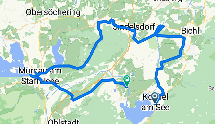
Szablon trasy
Z Kochel do Schlehdorf

- 31 min
- Czas
- 8,1 km
- Dystans
- 12 m
- Przewyższenia
- 25 m
- Spadek
- 15,8 km/h
- Śr. Prędkość
- 619 m
- Maks. wysokość
This relaxed ride takes you from the lakeside village of Kochel to the peaceful hamlet of Schlehdorf, hugging the northern shore of the beautiful Kochelsee. At just over 8 km, it’s a perfect easy outing with only gentle climbs—ideal for families or a mellow spin.
You’ll start off in Kochel, famous for its stunning setting beneath the Bavarian Alps and the excellent Franz Marc Museum (worth a visit if you have time!). The route mainly follows quiet roads and wide paths, with a few stretches of asphalt and even some light gravel, so any bike with decent tires will do.
You’ll skirt the lake for gorgeous water views, with the mountains mirrored in the surface if the weather’s right. Approaching Schlehdorf, your endpoint, you can check out the peaceful Kloster Schlehdorf — a historic monastery set against a backdrop of Alpine peaks.
This route offers laid-back cycling, big views, and a great taste of Upper Bavaria’s laid-back charm. Pack a picnic or stop for coffee—the scenery’s worth lingering over!
Wspólnota
Najlepsi użytkownicy w tym regionie


Od naszej społeczności
Najlepsze trasy rowerowe z Kochel do Schlehdorf


KESSELBERGSTRAßE, por Kockel am See
Trasa rowerowa w Kochel, Bawaria, Niemcy
- 5,9 km
- Dystans
- 359 m
- Przewyższenia
- 86 m
- Spadek


Bahnhofstraße 29–31, Kochel am See nach Urfeld 4, Kochel am See
Trasa rowerowa w Kochel, Bawaria, Niemcy
- 9,7 km
- Dystans
- 944 m
- Przewyższenia
- 740 m
- Spadek

Kochel am See nach Urfeld 4B, Kochel am See
Trasa rowerowa w Kochel, Bawaria, Niemcy
- 7,7 km
- Dystans
- 465 m
- Przewyższenia
- 276 m
- Spadek

B11 82, Kochel am See nach Am Tanneneck 6, Kochel am See
Trasa rowerowa w Kochel, Bawaria, Niemcy
- 9,4 km
- Dystans
- 542 m
- Przewyższenia
- 340 m
- Spadek

Mittenwalder Straße 52–54, Kochel am See to Urfeld 16, Kochel am See
Trasa rowerowa w Kochel, Bawaria, Niemcy
- 7 km
- Dystans
- 321 m
- Przewyższenia
- 111 m
- Spadek


Kochel, Kochel am See nach Kocheler Straße 36, Schlehdorf
Trasa rowerowa w Kochel, Bawaria, Niemcy
- 4,9 km
- Dystans
- 7 m
- Przewyższenia
- 14 m
- Spadek

Herzogstandweg 3, Kochel am See nach B11 28, Kochel am See
Trasa rowerowa w Kochel, Bawaria, Niemcy
- 7,6 km
- Dystans
- 469 m
- Przewyższenia
- 282 m
- Spadek
Odkryj więcej tras
 In Kochel
- Dystans
- 5,1 km
- Przewyższenia
- 87 m
- Spadek
- 92 m
- Lokalizacja
- Kochel, Bawaria, Niemcy
 Bahnhofstraße 29–31, Kochel am See nach Urfeld 4, Kochel am See
- Dystans
- 9,7 km
- Przewyższenia
- 944 m
- Spadek
- 740 m
- Lokalizacja
- Kochel, Bawaria, Niemcy
 Kochel am See nach Urfeld 4B, Kochel am See
- Dystans
- 7,7 km
- Przewyższenia
- 465 m
- Spadek
- 276 m
- Lokalizacja
- Kochel, Bawaria, Niemcy
 B11 82, Kochel am See nach Am Tanneneck 6, Kochel am See
- Dystans
- 9,4 km
- Przewyższenia
- 542 m
- Spadek
- 340 m
- Lokalizacja
- Kochel, Bawaria, Niemcy
 Mittenwalder Straße 52–54, Kochel am See to Urfeld 16, Kochel am See
- Dystans
- 7 km
- Przewyższenia
- 321 m
- Spadek
- 111 m
- Lokalizacja
- Kochel, Bawaria, Niemcy
 Kesselberg test
- Dystans
- 7,6 km
- Przewyższenia
- 474 m
- Spadek
- 266 m
- Lokalizacja
- Kochel, Bawaria, Niemcy
 Kochel, Kochel am See nach Kocheler Straße 36, Schlehdorf
- Dystans
- 4,9 km
- Przewyższenia
- 7 m
- Spadek
- 14 m
- Lokalizacja
- Kochel, Bawaria, Niemcy
 Herzogstandweg 3, Kochel am See nach B11 28, Kochel am See
- Dystans
- 7,6 km
- Przewyższenia
- 469 m
- Spadek
- 282 m
- Lokalizacja
- Kochel, Bawaria, Niemcy