

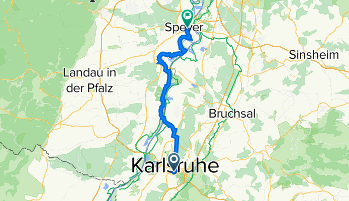
Szablon trasy
Z Karlsruhe do Spira

- 3 h 6 min
- Czas
- 55,4 km
- Dystans
- 147 m
- Przewyższenia
- 155 m
- Spadek
- 17,9 km/h
- Śr. Prędkość
- 121 m
- Maks. wysokość
This lovely ride takes you from Karlsruhe, a vibrant university city known for its fan-shaped layout and proximity to the Black Forest, up to the historic cathedral city of Speyer on the Rhine. Covering about 55 km, the route is mostly flat with very gentle climbs, making it perfect for a relaxed day’s adventure.
You’ll be gliding along smooth asphalt for most of the way, with only a few short sections of paving stones and concrete — so don’t worry about rough surfaces. The journey weaves through peaceful countryside tracks and quiet roads, avoiding busy traffic almost entirely.
Expect leafy riverside paths, tranquil farmland, and pretty little villages along the way. When you roll into Speyer, make sure to check out the UNESCO-listed Speyer Cathedral, one of Europe’s oldest and largest Romanesque churches. All in all, a scenic and approachable route that gives you a taste of classic southwestern Germany!
Wspólnota
Najlepsi użytkownicy w tym regionie


Od naszej społeczności
Najlepsze trasy rowerowe z Karlsruhe do Spira

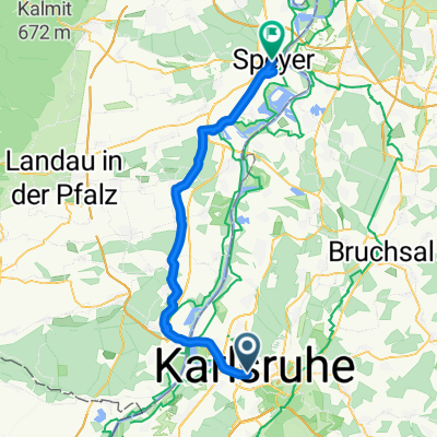
Karlsruhe - Speyer
Trasa rowerowa w Karlsruhe, Badenia-Wirtembergia, Niemcy
- 50,3 km
- Dystans
- 88 m
- Przewyższenia
- 104 m
- Spadek

ETT 3 Morgens Karlsruhe Speyer
Trasa rowerowa w Karlsruhe, Badenia-Wirtembergia, Niemcy
- 52,3 km
- Dystans
- 45 m
- Przewyższenia
- 58 m
- Spadek

#12 Karlsruhe to Speyer
Trasa rowerowa w Karlsruhe, Badenia-Wirtembergia, Niemcy
- 51,1 km
- Dystans
- 50 m
- Przewyższenia
- 71 m
- Spadek

KA-Waldstadt nach Speyer (60 km)
Trasa rowerowa w Karlsruhe, Badenia-Wirtembergia, Niemcy
- 59,3 km
- Dystans
- 85 m
- Przewyższenia
- 97 m
- Spadek

RR13 - Karlsruhe > Speyer
Trasa rowerowa w Karlsruhe, Badenia-Wirtembergia, Niemcy
- 53 km
- Dystans
- 217 m
- Przewyższenia
- 230 m
- Spadek

Karlsruhe - Speyer à gauche du Rhin 53 km
Trasa rowerowa w Karlsruhe, Badenia-Wirtembergia, Niemcy
- 52,9 km
- Dystans
- 62 m
- Przewyższenia
- 75 m
- Spadek

9 Tag Karlsruhe Speyer
Trasa rowerowa w Karlsruhe, Badenia-Wirtembergia, Niemcy
- 58,3 km
- Dystans
- 63 m
- Przewyższenia
- 82 m
- Spadek

R5. Karlsruhe to Speyer 51.6km S13
Trasa rowerowa w Karlsruhe, Badenia-Wirtembergia, Niemcy
- 51,6 km
- Dystans
- 194 m
- Przewyższenia
- 206 m
- Spadek

KAR-SPE
Trasa rowerowa w Karlsruhe, Badenia-Wirtembergia, Niemcy
- 52,3 km
- Dystans
- 43 m
- Przewyższenia
- 58 m
- Spadek

Rhein 2016 D1 - Karlsruhe-Speyer
Trasa rowerowa w Karlsruhe, Badenia-Wirtembergia, Niemcy
- 42,6 km
- Dystans
- 60 m
- Przewyższenia
- 74 m
- Spadek

RR13 Karlsruhe-Speyer.kml_RR13 Karlsruhe-Speyer
Trasa rowerowa w Karlsruhe, Badenia-Wirtembergia, Niemcy
- 51,6 km
- Dystans
- 0 m
- Przewyższenia
- 0 m
- Spadek
RR13 Karlsruhe-Speyer.kml - RR13 Karlsruhe-Speyer.kml_RR13 Karlsruhe-Speyer
Trasa rowerowa w Karlsruhe, Badenia-Wirtembergia, Niemcy
- 51,8 km
- Dystans
- 160 m
- Przewyższenia
- 182 m
- Spadek
Odkryj więcej tras
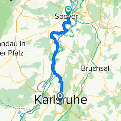
 RR13 - Karlsruhe > Speyer
- Dystans
- 53 km
- Przewyższenia
- 217 m
- Spadek
- 230 m
- Lokalizacja
- Karlsruhe, Badenia-Wirtembergia, Niemcy
 Karlsruhe - Speyer à gauche du Rhin 53 km
- Dystans
- 52,9 km
- Przewyższenia
- 62 m
- Spadek
- 75 m
- Lokalizacja
- Karlsruhe, Badenia-Wirtembergia, Niemcy
 9 Tag Karlsruhe Speyer
- Dystans
- 58,3 km
- Przewyższenia
- 63 m
- Spadek
- 82 m
- Lokalizacja
- Karlsruhe, Badenia-Wirtembergia, Niemcy
 R5. Karlsruhe to Speyer 51.6km S13
- Dystans
- 51,6 km
- Przewyższenia
- 194 m
- Spadek
- 206 m
- Lokalizacja
- Karlsruhe, Badenia-Wirtembergia, Niemcy
 KAR-SPE
- Dystans
- 52,3 km
- Przewyższenia
- 43 m
- Spadek
- 58 m
- Lokalizacja
- Karlsruhe, Badenia-Wirtembergia, Niemcy
 Rhein 2016 D1 - Karlsruhe-Speyer
- Dystans
- 42,6 km
- Przewyższenia
- 60 m
- Spadek
- 74 m
- Lokalizacja
- Karlsruhe, Badenia-Wirtembergia, Niemcy
 RR13 Karlsruhe-Speyer.kml_RR13 Karlsruhe-Speyer
- Dystans
- 51,6 km
- Przewyższenia
- 0 m
- Spadek
- 0 m
- Lokalizacja
- Karlsruhe, Badenia-Wirtembergia, Niemcy
 RR13 Karlsruhe-Speyer.kml - RR13 Karlsruhe-Speyer.kml_RR13 Karlsruhe-Speyer
- Dystans
- 51,8 km
- Przewyższenia
- 160 m
- Spadek
- 182 m
- Lokalizacja
- Karlsruhe, Badenia-Wirtembergia, Niemcy
Trasy z Karlsruhe
Jednodniowa wycieczka rowerowa od
Z Karlsruhe do Strasburg
Jednodniowa wycieczka rowerowa od
Z Karlsruhe do Bietigheim
Szybka przejażdżka rowerowa od
Z Karlsruhe do Weingarten
Szybka przejażdżka rowerowa od
Z Karlsruhe do Rheinstetten
Trasy do Spira
Jednodniowa wycieczka rowerowa od
Z Heidelberg do Spira
Jednodniowa wycieczka rowerowa od
Z Ludwigshafen do Spira