
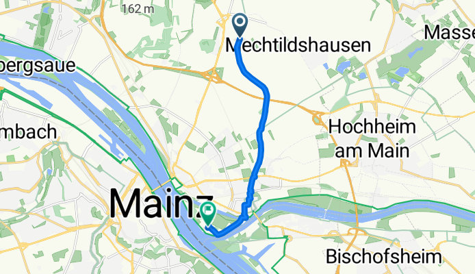
Szybka przejażdżka rowerowa z Hochheim am Main do Moguncja
Dostosuj własną trasę na podstawie naszego szablonu lub zobacz, jak nasza społeczność najchętniej jeździ z Hochheim am Main do Moguncja.
Szablon trasy
Z Hochheim am Main do Moguncja

- 44 min
- Czas
- 12,2 km
- Dystans
- 60 m
- Przewyższenia
- 62 m
- Spadek
- 16,8 km/h
- Śr. Prędkość
- 131 m
- Maks. wysokość
This is a perfect ride if you want a laid-back day exploring the heart of the Rheingau region! Starting from Hochheim am Main—a charming wine town famous for its Riesling and centuries-old vineyards—you’re treated to gentle scenery the whole way through. The route is just over 12 km, so it’s easily done in under an hour, even with a few breaks to snap riverside photos or check out local sights.
Most of your journey follows quiet roads and smooth paths, with excellent riding surfaces (over 97% paved), making it comfortable even for casual cyclists. You’ll roll through the scenic countryside, enjoying an easy ride with minimal elevation, and there are just a few gentle ups and downs to keep things interesting.
The trip winds up in Mainz, a bustling university city loaded with history—think Gutenberg and Roman ruins. Grab a coffee in the picturesque old town before heading back or exploring more. All in all, it’s a super pleasant, low-stress ride with plenty of options to linger in gorgeous spots along the way.
Wspólnota
Najlepsi użytkownicy w tym regionie


Od naszej społeczności
Najlepsze trasy rowerowe z Hochheim am Main do Moguncja

kleine Rheinrunde von Mainz bis Oestrich
Trasa rowerowa w Hochheim am Main, Hesja, Niemcy
- 48,6 km
- Dystans
- 80 m
- Przewyższenia
- 76 m
- Spadek
Rheinrunde von Hochheim über Oestrich zum Mainzer Rheinstrand
Trasa rowerowa w Hochheim am Main, Hesja, Niemcy
- 50,3 km
- Dystans
- 46 m
- Przewyższenia
- 87 m
- Spadek

kleine Rheinrunde von Mainz bis Oestrich CLONED FROM ROUTE 550499 CLONED FROM ROUTE 2048172
Trasa rowerowa w Hochheim am Main, Hesja, Niemcy
- 51,3 km
- Dystans
- 75 m
- Przewyższenia
- 109 m
- Spadek

Rhein/Main Rundroute
Trasa rowerowa w Hochheim am Main, Hesja, Niemcy
- 12,1 km
- Dystans
- 55 m
- Przewyższenia
- 63 m
- Spadek

mcdonalds aussen rum
Trasa rowerowa w Hochheim am Main, Hesja, Niemcy
- 9,3 km
- Dystans
- 22 m
- Przewyższenia
- 63 m
- Spadek
Wiesbaden nach Franziska-Retzinger-Promenade, Wiesbaden
Trasa rowerowa w Hochheim am Main, Hesja, Niemcy
- 7,1 km
- Dystans
- 12 m
- Przewyższenia
- 68 m
- Spadek

Im Eigen 11–13, Hochheim am Main nach Zitadelle 1F, Mainz
Trasa rowerowa w Hochheim am Main, Hesja, Niemcy
- 8,8 km
- Dystans
- 44 m
- Przewyższenia
- 51 m
- Spadek

20150826_192024.gpx
Trasa rowerowa w Hochheim am Main, Hesja, Niemcy
- 9,4 km
- Dystans
- 86 m
- Przewyższenia
- 44 m
- Spadek

Straubinger Straße 5–9, Wiesbaden nach Jakob-Schick-Straße 1, Wiesbaden
Trasa rowerowa w Hochheim am Main, Hesja, Niemcy
- 6,9 km
- Dystans
- 158 m
- Przewyższenia
- 205 m
- Spadek

Mechthildshausen 1, Wiesbaden nach Im Sampel 60, Wiesbaden
Trasa rowerowa w Hochheim am Main, Hesja, Niemcy
- 6,1 km
- Dystans
- 10 m
- Przewyższenia
- 58 m
- Spadek

Wiesbaden Centre, Wiesbaden to Jakob-Schick-Straße 16, Wiesbaden
Trasa rowerowa w Hochheim am Main, Hesja, Niemcy
- 6 km
- Dystans
- 3 m
- Przewyższenia
- 55 m
- Spadek

Bernhard-Walch-Weg 5, Hochheim am Main nach Schillerplatz, Mainz
Trasa rowerowa w Hochheim am Main, Hesja, Niemcy
- 8,7 km
- Dystans
- 18 m
- Przewyższenia
- 42 m
- Spadek
Odkryj więcej tras
 mcdonalds aussen rum
- Dystans
- 9,3 km
- Przewyższenia
- 22 m
- Spadek
- 63 m
- Lokalizacja
- Hochheim am Main, Hesja, Niemcy
 Wiesbaden nach Franziska-Retzinger-Promenade, Wiesbaden
- Dystans
- 7,1 km
- Przewyższenia
- 12 m
- Spadek
- 68 m
- Lokalizacja
- Hochheim am Main, Hesja, Niemcy
 Im Eigen 11–13, Hochheim am Main nach Zitadelle 1F, Mainz
- Dystans
- 8,8 km
- Przewyższenia
- 44 m
- Spadek
- 51 m
- Lokalizacja
- Hochheim am Main, Hesja, Niemcy
 20150826_192024.gpx
- Dystans
- 9,4 km
- Przewyższenia
- 86 m
- Spadek
- 44 m
- Lokalizacja
- Hochheim am Main, Hesja, Niemcy
 Straubinger Straße 5–9, Wiesbaden nach Jakob-Schick-Straße 1, Wiesbaden
- Dystans
- 6,9 km
- Przewyższenia
- 158 m
- Spadek
- 205 m
- Lokalizacja
- Hochheim am Main, Hesja, Niemcy
 Mechthildshausen 1, Wiesbaden nach Im Sampel 60, Wiesbaden
- Dystans
- 6,1 km
- Przewyższenia
- 10 m
- Spadek
- 58 m
- Lokalizacja
- Hochheim am Main, Hesja, Niemcy
 Wiesbaden Centre, Wiesbaden to Jakob-Schick-Straße 16, Wiesbaden
- Dystans
- 6 km
- Przewyższenia
- 3 m
- Spadek
- 55 m
- Lokalizacja
- Hochheim am Main, Hesja, Niemcy
 Bernhard-Walch-Weg 5, Hochheim am Main nach Schillerplatz, Mainz
- Dystans
- 8,7 km
- Przewyższenia
- 18 m
- Spadek
- 42 m
- Lokalizacja
- Hochheim am Main, Hesja, Niemcy
Trasy z Hochheim am Main
Szybka przejażdżka rowerowa od
Z Hochheim am Main do Wiesbaden
Trasy do Moguncja
Jednodniowa wycieczka rowerowa od
Z Bingen am Rhein do Moguncja
Jednodniowa wycieczka rowerowa od
Z Wormacja do Moguncja
Szybka przejażdżka rowerowa od
Z Klein-Winternheim do Moguncja
Szybka przejażdżka rowerowa od
Z Ginsheim-Gustavsburg do Moguncja