
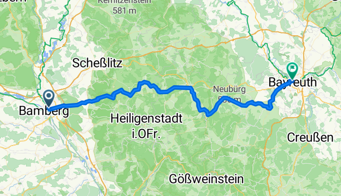
Szablon trasy
Z Bamberg do Bayreuth

- 5 h 16 min
- Czas
- 83 km
- Dystans
- 1003 m
- Przewyższenia
- 907 m
- Spadek
- 15,8 km/h
- Śr. Prędkość
- 516 m
- Maks. wysokość
Bamberg to Bayreuth Cycling Route
Kick off your ride in Bamberg, a UNESCO-listed city famous for its medieval old town and riverside charm. The route to Bayreuth covers about 83 km, perfect for a solid day in the saddle with just over 1,000 meters of climbing to keep things interesting.
You'll spend most of your time cruising peaceful country roads (about 40%) with scenic stretches through forests and farmlands. There’s a good mix of smooth asphalt and some gravelly bits, so a sturdy hybrid or gravel bike will serve you well. Roughly 27% is on paths—expect some car-free bliss—while the odd track brings you up close with rural Franconia. Max elevation tops out at 516 meters, so there are a couple of climbs, but nothing too fierce.
End your tour in Bayreuth, known for its famous Wagner Festival and grand baroque architecture. Both towns offer plenty of beer gardens, so you’re never far from a reward at the finish line! All in all, a beautiful and varied ride through northern Bavaria’s finest landscapes.
Wspólnota
Najlepsi użytkownicy w tym regionie


Od naszej społeczności
Najlepsze trasy rowerowe z Bamberg do Bayreuth

BA-Hollfeld-Bayreuth
Trasa rowerowa w Bamberg, Bawaria, Niemcy
- 62,5 km
- Dystans
- 676 m
- Przewyższenia
- 578 m
- Spadek

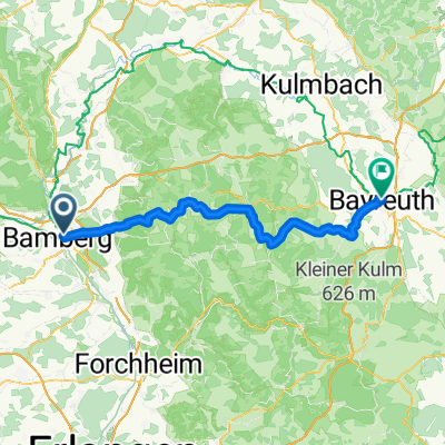
5. Bamberg - Bayreuth
Trasa rowerowa w Bamberg, Bawaria, Niemcy
- 92,3 km
- Dystans
- 201 m
- Przewyższenia
- 111 m
- Spadek

Bamberg-Ellerberg-Hollfeld-Plankenfels-Eckersdorf-Bayreuth
Trasa rowerowa w Bamberg, Bawaria, Niemcy
- 59,8 km
- Dystans
- 474 m
- Przewyższenia
- 377 m
- Spadek

Neckar/Main 2013 / XI
Trasa rowerowa w Bamberg, Bawaria, Niemcy
- 106,7 km
- Dystans
- 203 m
- Przewyższenia
- 99 m
- Spadek

Bamberg - Beyreuth (Option 1)
Trasa rowerowa w Bamberg, Bawaria, Niemcy
- 62,9 km
- Dystans
- 715 m
- Przewyższenia
- 618 m
- Spadek

Bamberg - Beyreuth (Option 2)
Trasa rowerowa w Bamberg, Bawaria, Niemcy
- 98,3 km
- Dystans
- 503 m
- Przewyższenia
- 397 m
- Spadek

Hochweg_Frnkische_Schweiz
Trasa rowerowa w Bamberg, Bawaria, Niemcy
- 68,6 km
- Dystans
- 723 m
- Przewyższenia
- 627 m
- Spadek

Bamberg14Heilige
Trasa rowerowa w Bamberg, Bawaria, Niemcy
- 130,4 km
- Dystans
- 967 m
- Przewyższenia
- 864 m
- Spadek


Bamberg - Bayreuth
Trasa rowerowa w Bamberg, Bawaria, Niemcy
- 108,6 km
- Dystans
- 521 m
- Przewyższenia
- 427 m
- Spadek

Einheitstour 2010
Trasa rowerowa w Bamberg, Bawaria, Niemcy
- 69,4 km
- Dystans
- 523 m
- Przewyższenia
- 421 m
- Spadek
Bamberg nach Hohenzollernplatz
Trasa rowerowa w Bamberg, Bawaria, Niemcy
- 68,4 km
- Dystans
- 723 m
- Przewyższenia
- 627 m
- Spadek
Odkryj więcej tras
 Bamberg - Beyreuth (Option 1)
- Dystans
- 62,9 km
- Przewyższenia
- 715 m
- Spadek
- 618 m
- Lokalizacja
- Bamberg, Bawaria, Niemcy
 Bamberg - Beyreuth (Option 2)
- Dystans
- 98,3 km
- Przewyższenia
- 503 m
- Spadek
- 397 m
- Lokalizacja
- Bamberg, Bawaria, Niemcy
 Hochweg_Frnkische_Schweiz
- Dystans
- 68,6 km
- Przewyższenia
- 723 m
- Spadek
- 627 m
- Lokalizacja
- Bamberg, Bawaria, Niemcy
 Bamberg14Heilige
- Dystans
- 130,4 km
- Przewyższenia
- 967 m
- Spadek
- 864 m
- Lokalizacja
- Bamberg, Bawaria, Niemcy
 sonntag
- Dystans
- 68,6 km
- Przewyższenia
- 872 m
- Spadek
- 777 m
- Lokalizacja
- Bamberg, Bawaria, Niemcy
 Bamberg - Bayreuth
- Dystans
- 108,6 km
- Przewyższenia
- 521 m
- Spadek
- 427 m
- Lokalizacja
- Bamberg, Bawaria, Niemcy
 Einheitstour 2010
- Dystans
- 69,4 km
- Przewyższenia
- 523 m
- Spadek
- 421 m
- Lokalizacja
- Bamberg, Bawaria, Niemcy
 Bamberg nach Hohenzollernplatz
- Dystans
- 68,4 km
- Przewyższenia
- 723 m
- Spadek
- 627 m
- Lokalizacja
- Bamberg, Bawaria, Niemcy
Trasy z Bamberg
Jednodniowa wycieczka rowerowa od
Z Bamberg do Norymberga
Jednodniowa wycieczka rowerowa od
Z Bamberg do Haßfurt