
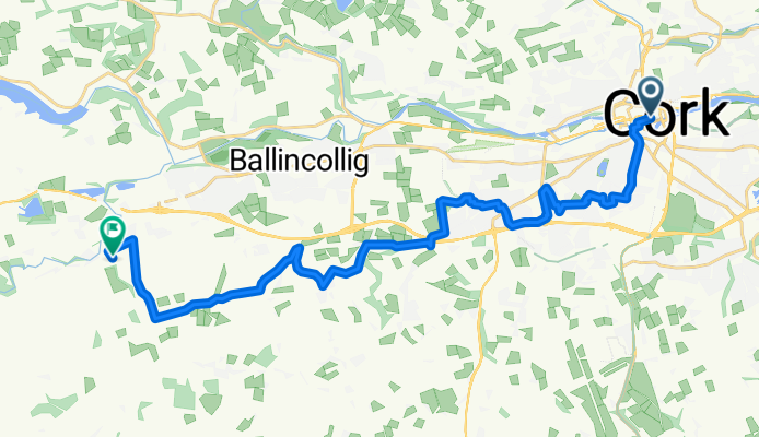
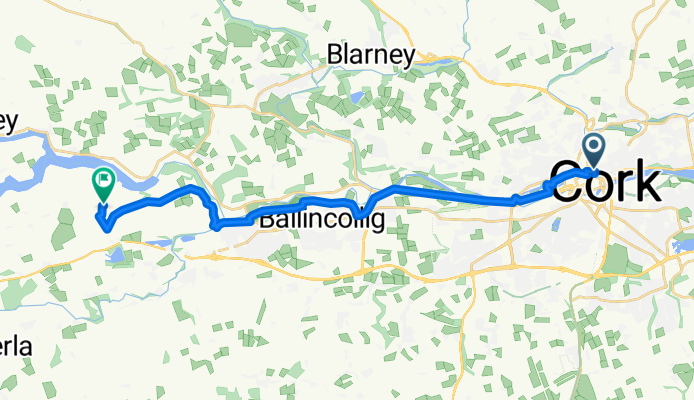
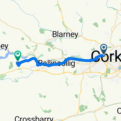
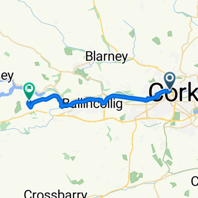
Szablon trasy
Z Cork do Killumney
- 1 h 18 min
- Czas
- 21,7 km
- Dystans
- 246 m
- Przewyższenia
- 219 m
- Spadek
- 16,8 km/h
- Śr. Prędkość
- 138 m
- Maks. wysokość
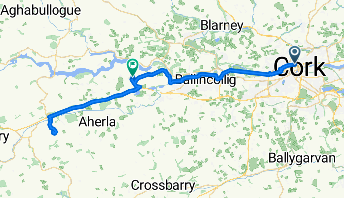
Roll out from Cork city centre, Ireland’s lively “Rebel City,” and follow the River Lee west past UCC. Pick up the cycle lanes along Western/Model Farm Road toward Ballincollig; if you fancy a break, detour into Ballincollig Regional Park by the river. Continue on the old Macroom road (R608) and then peel onto quiet local lanes for the last stretch into Killumney, a small village in the Ovens area that was once served by the Cork–Macroom railway.
It’s about 22 km with roughly 250 m of climbing. Most of it is smooth asphalt on quiet roads and cycleways, with a short busier section as you leave the city. Expect gentle rollers and a highest point around 140 m—nothing too steep, just steady spins.
Pre-ride, the English Market in Cork is a top spot for snacks; at the finish you’ll get a calm rural vibe and easy links toward Ovens and the Lee Valley.
Wspólnota
Najlepsi użytkownicy w tym regionie


Od naszej społeczności
Najlepsze trasy rowerowe z Cork do Killumney


Route from Saint Patrick's Hill
Trasa rowerowa w Cork, Munster, Irlandia
- 18,9 km
- Dystans
- 221 m
- Przewyższenia
- 214 m
- Spadek


Route from MacCurtain Street 33/34
Trasa rowerowa w Cork, Munster, Irlandia
- 44,4 km
- Dystans
- 283 m
- Przewyższenia
- 279 m
- Spadek


Route from Saint Patrick's Hill
Trasa rowerowa w Cork, Munster, Irlandia
- 19 km
- Dystans
- 219 m
- Przewyższenia
- 215 m
- Spadek

Route from Saint Patrick's Hill
Trasa rowerowa w Cork, Munster, Irlandia
- 19,9 km
- Dystans
- 237 m
- Przewyższenia
- 237 m
- Spadek

Route from Saint Patrick's Hill
Trasa rowerowa w Cork, Munster, Irlandia
- 19,6 km
- Dystans
- 309 m
- Przewyższenia
- 306 m
- Spadek

Route from Saint Patrick's Hill
Trasa rowerowa w Cork, Munster, Irlandia
- 19 km
- Dystans
- 218 m
- Przewyższenia
- 210 m
- Spadek

Route from Saint Patrick's Hill
Trasa rowerowa w Cork, Munster, Irlandia
- 18,9 km
- Dystans
- 186 m
- Przewyższenia
- 175 m
- Spadek


Route from Saint Patrick's Hill
Trasa rowerowa w Cork, Munster, Irlandia
- 18,8 km
- Dystans
- 217 m
- Przewyższenia
- 206 m
- Spadek
Route from Saint Patrick's Hill
Trasa rowerowa w Cork, Munster, Irlandia
- 18,6 km
- Dystans
- 223 m
- Przewyższenia
- 219 m
- Spadek

Route from Saint Patrick's Hill
Trasa rowerowa w Cork, Munster, Irlandia
- 19,1 km
- Dystans
- 210 m
- Przewyższenia
- 215 m
- Spadek
Route from Saint Patrick's Hill
Trasa rowerowa w Cork, Munster, Irlandia
- 18,7 km
- Dystans
- 225 m
- Przewyższenia
- 225 m
- Spadek
Odkryj więcej tras
 Route from Saint Patrick's Hill
- Dystans
- 19,6 km
- Przewyższenia
- 309 m
- Spadek
- 306 m
- Lokalizacja
- Cork, Munster, Irlandia
 Route from Saint Patrick's Hill
- Dystans
- 19 km
- Przewyższenia
- 218 m
- Spadek
- 210 m
- Lokalizacja
- Cork, Munster, Irlandia
 Route from Saint Patrick's Hill
- Dystans
- 18,9 km
- Przewyższenia
- 186 m
- Spadek
- 175 m
- Lokalizacja
- Cork, Munster, Irlandia
 Sporty route
- Dystans
- 18,9 km
- Przewyższenia
- 199 m
- Spadek
- 176 m
- Lokalizacja
- Cork, Munster, Irlandia
 Route from Saint Patrick's Hill
- Dystans
- 18,8 km
- Przewyższenia
- 217 m
- Spadek
- 206 m
- Lokalizacja
- Cork, Munster, Irlandia
 Route from Saint Patrick's Hill
- Dystans
- 18,6 km
- Przewyższenia
- 223 m
- Spadek
- 219 m
- Lokalizacja
- Cork, Munster, Irlandia
 Route from Saint Patrick's Hill
- Dystans
- 19,1 km
- Przewyższenia
- 210 m
- Spadek
- 215 m
- Lokalizacja
- Cork, Munster, Irlandia
 Route from Saint Patrick's Hill
- Dystans
- 18,7 km
- Przewyższenia
- 225 m
- Spadek
- 225 m
- Lokalizacja
- Cork, Munster, Irlandia