
Bikepacking z Val d'Isère do Valloire
Dostosuj własną trasę na podstawie naszego szablonu lub zobacz, jak nasza społeczność najchętniej jeździ z Val d'Isère do Valloire.
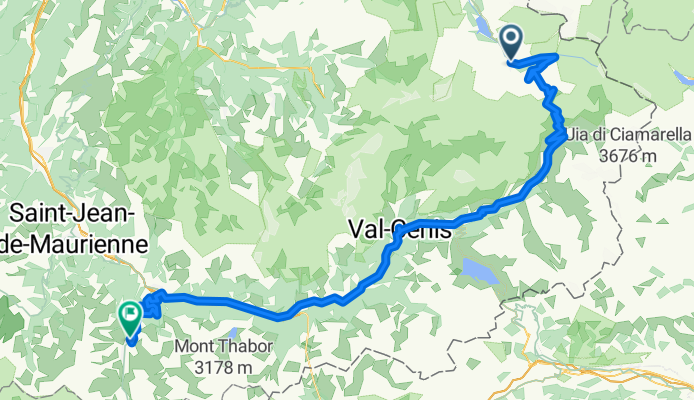
Szablon trasy
Z Val d'Isère do Valloire

- 17 h 7 min
- Czas
- 159,9 km
- Dystans
- 7841 m
- Przewyższenia
- 8266 m
- Spadek
- 9,3 km/h
- Śr. Prędkość
- 2219 m
- Maks. wysokość
This epic ride takes you from Val d’Isère, a world-famous ski resort perched high in the French Alps, all the way to the picturesque mountain town of Valloire. Be ready for a challenging adventure: you'll spin through nearly 160 km of alpine terrain, racking up over 7,800 meters of climbing and a bit more descending! The route soars above 2,200 meters, so the air gets crisp and the views unforgettable.
Expect a real mix of surfaces: you'll roll on smooth asphalt, cruise quiet roads, and tackle stretches of gravel and tracks (so a gravel or adventure bike is your friend here). About half the route may lack formal paving, adding to the wild mountain feel.
As you traverse legendary cols between Savoie and Haute-Maurienne, soak up stunning scenery, cascading streams, and classic Alpine switchbacks. When you finally descend into Valloire—a charming village famous for its baroque church and gateway to the Col du Galibier—you’ll have truly earned your tartiflette!
Wspólnota
Najlepsi użytkownicy w tym regionie


Od naszej społeczności
Najlepsze trasy rowerowe z Val d'Isère do Valloire
![[3.6] Val d'Isere---> Valoire](https://media.bikemap.net/routes/4671166/staticmaps/in_32d12d43-96c5-454d-bf1f-ec39c0715492_694x400_bikemap-2021-3D-static.png)
[3.6] Val d'Isere---> Valoire
Trasa rowerowa w Val d'Isère, Owernia-Rodan-Alpy, Francja
- 106,7 km
- Dystans
- 1930 m
- Przewyższenia
- 2719 m
- Spadek

RdGA Tag 4
Trasa rowerowa w Val d'Isère, Owernia-Rodan-Alpy, Francja
- 105,1 km
- Dystans
- 1854 m
- Przewyższenia
- 2275 m
- Spadek

2. Col de l'Iseran
Trasa rowerowa w Val d'Isère, Owernia-Rodan-Alpy, Francja
- 112,4 km
- Dystans
- 1994 m
- Przewyższenia
- 2431 m
- Spadek

Val d'Isere - Valloire
Trasa rowerowa w Val d'Isère, Owernia-Rodan-Alpy, Francja
- 106,4 km
- Dystans
- 2440 m
- Przewyższenia
- 2990 m
- Spadek

Val d'Isère-Valoire
Trasa rowerowa w Val d'Isère, Owernia-Rodan-Alpy, Francja
- 100,8 km
- Dystans
- 1886 m
- Przewyższenia
- 2312 m
- Spadek

3 MI RdGA
Trasa rowerowa w Val d'Isère, Owernia-Rodan-Alpy, Francja
- 106,7 km
- Dystans
- 1881 m
- Przewyższenia
- 2283 m
- Spadek

Route des Grandes Alpes 3 Val d'Isere - Valloire
Trasa rowerowa w Val d'Isère, Owernia-Rodan-Alpy, Francja
- 107,2 km
- Dystans
- 1951 m
- Przewyższenia
- 2448 m
- Spadek

é"'(§è('"
Trasa rowerowa w Val d'Isère, Owernia-Rodan-Alpy, Francja
- 213,8 km
- Dystans
- 4554 m
- Przewyższenia
- 4614 m
- Spadek

Alpen 1994 Etappe 8
Trasa rowerowa w Val d'Isère, Owernia-Rodan-Alpy, Francja
- 60,5 km
- Dystans
- 1029 m
- Przewyższenia
- 1103 m
- Spadek

Route des Grandes Alpes 2019 Alt. 2 - Tag 3
Trasa rowerowa w Val d'Isère, Owernia-Rodan-Alpy, Francja
- 149,1 km
- Dystans
- 2218 m
- Przewyższenia
- 2649 m
- Spadek

Route des Grandes Alpes 2019 Alt. 2.1 - Tag 3
Trasa rowerowa w Val d'Isère, Owernia-Rodan-Alpy, Francja
- 146,4 km
- Dystans
- 2189 m
- Przewyższenia
- 2577 m
- Spadek
val disere valloire
Trasa rowerowa w Val d'Isère, Owernia-Rodan-Alpy, Francja
- 107,2 km
- Dystans
- 1862 m
- Przewyższenia
- 2294 m
- Spadek
Odkryj więcej tras
 Val d'Isère-Valoire
- Dystans
- 100,8 km
- Przewyższenia
- 1886 m
- Spadek
- 2312 m
- Lokalizacja
- Val d'Isère, Owernia-Rodan-Alpy, Francja
 3 MI RdGA
- Dystans
- 106,7 km
- Przewyższenia
- 1881 m
- Spadek
- 2283 m
- Lokalizacja
- Val d'Isère, Owernia-Rodan-Alpy, Francja
 Route des Grandes Alpes 3 Val d'Isere - Valloire
- Dystans
- 107,2 km
- Przewyższenia
- 1951 m
- Spadek
- 2448 m
- Lokalizacja
- Val d'Isère, Owernia-Rodan-Alpy, Francja
 é"'(§è('"
- Dystans
- 213,8 km
- Przewyższenia
- 4554 m
- Spadek
- 4614 m
- Lokalizacja
- Val d'Isère, Owernia-Rodan-Alpy, Francja
 Alpen 1994 Etappe 8
- Dystans
- 60,5 km
- Przewyższenia
- 1029 m
- Spadek
- 1103 m
- Lokalizacja
- Val d'Isère, Owernia-Rodan-Alpy, Francja
 Route des Grandes Alpes 2019 Alt. 2 - Tag 3
- Dystans
- 149,1 km
- Przewyższenia
- 2218 m
- Spadek
- 2649 m
- Lokalizacja
- Val d'Isère, Owernia-Rodan-Alpy, Francja
 Route des Grandes Alpes 2019 Alt. 2.1 - Tag 3
- Dystans
- 146,4 km
- Przewyższenia
- 2189 m
- Spadek
- 2577 m
- Lokalizacja
- Val d'Isère, Owernia-Rodan-Alpy, Francja
 val disere valloire
- Dystans
- 107,2 km
- Przewyższenia
- 1862 m
- Spadek
- 2294 m
- Lokalizacja
- Val d'Isère, Owernia-Rodan-Alpy, Francja
Trasy z Val d'Isère
Bikepacking od
Z Val d'Isère do Briançon
Bikepacking od
Z Val d'Isère do Modane
Trasy do Valloire
Jednodniowa wycieczka rowerowa od
Z Huez do Valloire
Jednodniowa wycieczka rowerowa od
Z Saint-Jean-de-Maurienne do Valloire
Rowerowa od
Z Saint-Michel-de-Maurienne do Valloire