
Bikepacking z Val d'Isère do Briançon
Dostosuj własną trasę na podstawie naszego szablonu lub zobacz, jak nasza społeczność najchętniej jeździ z Val d'Isère do Briançon.
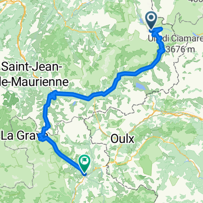
Szablon trasy
Z Val d'Isère do Briançon

- 21 h 46 min
- Czas
- 218,6 km
- Dystans
- 9762 m
- Przewyższenia
- 10 291 m
- Spadek
- 10 km/h
- Śr. Prędkość
- 2634 m
- Maks. wysokość
If you’re up for an epic Alpine ride, the route from Val d’Isère to Briançon is a real adventure! Starting in the high-altitude ski resort town of Val d’Isère (famous for its world-class slopes and stunning mountain scenery), you’ll wind your way over 218 km of serious elevation changes—nearly 10,000 meters of climbing and over 10,000 meters of descent. Expect to top out at a lofty 2,634 meters!
You'll mostly ride on quiet roads and tracks, with surfaces ranging from smooth asphalt to stretches of gravel and unpaved ground. Be ready for some remote, rugged sections—this isn’t your casual Sunday spin!
The finish in Briançon, Europe’s highest city, is the perfect reward. This historic town is packed with Vauban fortifications and a buzzing mountain vibe. With breathtaking scenery around every corner, this is a bucket-list route for seasoned cyclists who crave challenge and Alpine beauty!
Wspólnota
Najlepsi użytkownicy w tym regionie


Od naszej społeczności
Najlepsze trasy rowerowe z Val d'Isère do Briançon

Tag 7. Val d Isere - Briancon Alternativ
Trasa rowerowa w Val d'Isère, Owernia-Rodan-Alpy, Francja
- 159,9 km
- Dystans
- 3013 m
- Przewyższenia
- 3633 m
- Spadek

RdGA - Rit 3: Val d'Isère - Briançon
Trasa rowerowa w Val d'Isère, Owernia-Rodan-Alpy, Francja
- 164,6 km
- Dystans
- 2983 m
- Przewyższenia
- 3560 m
- Spadek

TransAlp2018-3
Trasa rowerowa w Val d'Isère, Owernia-Rodan-Alpy, Francja
- 132,4 km
- Dystans
- 2986 m
- Przewyższenia
- 3198 m
- Spadek

Piemont 3
Trasa rowerowa w Val d'Isère, Owernia-Rodan-Alpy, Francja
- 130,3 km
- Dystans
- 2715 m
- Przewyższenia
- 3240 m
- Spadek

BikeAlp - day14
Trasa rowerowa w Val d'Isère, Owernia-Rodan-Alpy, Francja
- 115,8 km
- Dystans
- 2123 m
- Przewyższenia
- 2203 m
- Spadek

15F02
Trasa rowerowa w Val d'Isère, Owernia-Rodan-Alpy, Francja
- 160,6 km
- Dystans
- 2939 m
- Przewyższenia
- 3578 m
- Spadek

Route Grandes Alpes HBU 2016 - 4
Trasa rowerowa w Val d'Isère, Owernia-Rodan-Alpy, Francja
- 110,6 km
- Dystans
- 2119 m
- Przewyższenia
- 2342 m
- Spadek

Tag 6, DO., 10.7.14
Trasa rowerowa w Val d'Isère, Owernia-Rodan-Alpy, Francja
- 143,7 km
- Dystans
- 2895 m
- Przewyższenia
- 3384 m
- Spadek

LAGO GINEVRA - MENTONE terza tappa
Trasa rowerowa w Val d'Isère, Owernia-Rodan-Alpy, Francja
- 163,2 km
- Dystans
- 2940 m
- Przewyższenia
- 3525 m
- Spadek

Lanslebourg - Briancon
Trasa rowerowa w Val d'Isère, Owernia-Rodan-Alpy, Francja
- 111,4 km
- Dystans
- 2076 m
- Przewyższenia
- 2232 m
- Spadek

Marmotte 4: Iseran - Montgenevre
Trasa rowerowa w Val d'Isère, Owernia-Rodan-Alpy, Francja
- 144,2 km
- Dystans
- 3215 m
- Przewyższenia
- 2836 m
- Spadek

D_Alp09=TDF12_Val D'Isere - Briancon
Trasa rowerowa w Val d'Isère, Owernia-Rodan-Alpy, Francja
- 159,7 km
- Dystans
- 3050 m
- Przewyższenia
- 3659 m
- Spadek
Odkryj więcej tras
 BikeAlp - day14
- Dystans
- 115,8 km
- Przewyższenia
- 2123 m
- Spadek
- 2203 m
- Lokalizacja
- Val d'Isère, Owernia-Rodan-Alpy, Francja
 15F02
15F02- Dystans
- 160,6 km
- Przewyższenia
- 2939 m
- Spadek
- 3578 m
- Lokalizacja
- Val d'Isère, Owernia-Rodan-Alpy, Francja
 Route Grandes Alpes HBU 2016 - 4
- Dystans
- 110,6 km
- Przewyższenia
- 2119 m
- Spadek
- 2342 m
- Lokalizacja
- Val d'Isère, Owernia-Rodan-Alpy, Francja
 Tag 6, DO., 10.7.14
- Dystans
- 143,7 km
- Przewyższenia
- 2895 m
- Spadek
- 3384 m
- Lokalizacja
- Val d'Isère, Owernia-Rodan-Alpy, Francja
 LAGO GINEVRA - MENTONE terza tappa
- Dystans
- 163,2 km
- Przewyższenia
- 2940 m
- Spadek
- 3525 m
- Lokalizacja
- Val d'Isère, Owernia-Rodan-Alpy, Francja
 Lanslebourg - Briancon
- Dystans
- 111,4 km
- Przewyższenia
- 2076 m
- Spadek
- 2232 m
- Lokalizacja
- Val d'Isère, Owernia-Rodan-Alpy, Francja
 Marmotte 4: Iseran - Montgenevre
- Dystans
- 144,2 km
- Przewyższenia
- 3215 m
- Spadek
- 2836 m
- Lokalizacja
- Val d'Isère, Owernia-Rodan-Alpy, Francja
 D_Alp09=TDF12_Val D'Isere - Briancon
- Dystans
- 159,7 km
- Przewyższenia
- 3050 m
- Spadek
- 3659 m
- Lokalizacja
- Val d'Isère, Owernia-Rodan-Alpy, Francja
Trasy z Val d'Isère
Bikepacking od
Z Val d'Isère do Modane
Bikepacking od
Z Val d'Isère do Valloire
Trasy do Briançon
Jednodniowa wycieczka rowerowa od
Z Jausiers do Briançon
Jednodniowa wycieczka rowerowa od
Z Huez do Briançon