
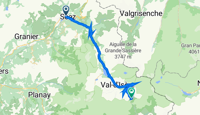
Jednodniowa wycieczka rowerowa z Séez do Val d'Isère
Dostosuj własną trasę na podstawie naszego szablonu lub zobacz, jak nasza społeczność najchętniej jeździ z Séez do Val d'Isère.
Szablon trasy
Z Séez do Val d'Isère

- 4 h 24 min
- Czas
- 35,7 km
- Dystans
- 2415 m
- Przewyższenia
- 1469 m
- Spadek
- 8,1 km/h
- Śr. Prędkość
- 1879 m
- Maks. wysokość
Get ready for a mountain adventure! This route takes you from the charming village of Séez, nestled at the gateway to the Haute Tarentaise valley, all the way to the famous ski resort of Val d’Isère. Covering almost 36 km and climbing over 2,400 meters, it’s a challenging ride—perfect if you love long climbs and stunning alpine views.
The first part rolls on quiet roads and cycleways before you hit the legendary ascent towards Val d’Isère. The surface is mostly paved, but expect some missing sections, so a road bike with tough tires (or a gravel bike) is a smart choice.
Séez is known for its historic church and lovely market, while Val d’Isère needs little introduction—it’s a world-class winter sports hub and part of the Espace Killy ski area. In summer, it transforms into an alpine playground for cyclists and hikers.
If you’re up for epic mountain scenery, sweeping hairpin bends, and a true taste of the French Alps, this route is for you. Don’t forget extra layers—the weather can change fast at nearly 1,900 meters elevation!
Wspólnota
Najlepsi użytkownicy w tym regionie


Od naszej społeczności
Najlepsze trasy rowerowe z Séez do Val d'Isère

Transalpine (11) Bourg St. Maurice - Vijaron
Trasa rowerowa w Séez, Owernia-Rodan-Alpy, Francja
- 64,9 km
- Dystans
- 2025 m
- Przewyższenia
- 1097 m
- Spadek


Seez - Lanslevillard
Trasa rowerowa w Séez, Owernia-Rodan-Alpy, Francja
- 76,7 km
- Dystans
- 1968 m
- Przewyższenia
- 1399 m
- Spadek

Iseran
Trasa rowerowa w Séez, Owernia-Rodan-Alpy, Francja
- 42,6 km
- Dystans
- 2037 m
- Przewyższenia
- 136 m
- Spadek

France Transalp Etappe3
Trasa rowerowa w Séez, Owernia-Rodan-Alpy, Francja
- 120,4 km
- Dystans
- 3645 m
- Przewyższenia
- 3080 m
- Spadek

Route des Grandes Alpes 2019 - stage 3
Trasa rowerowa w Séez, Owernia-Rodan-Alpy, Francja
- 76,1 km
- Dystans
- 2041 m
- Przewyższenia
- 1443 m
- Spadek
Col de l'Iseran
Trasa rowerowa w Séez, Owernia-Rodan-Alpy, Francja
- 45,5 km
- Dystans
- 2328 m
- Przewyższenia
- 434 m
- Spadek

Col de l'Iseran cycle
Trasa rowerowa w Séez, Owernia-Rodan-Alpy, Francja
- 46,5 km
- Dystans
- 2410 m
- Przewyższenia
- 519 m
- Spadek

Etape 4b - Route grands Alpes
Trasa rowerowa w Séez, Owernia-Rodan-Alpy, Francja
- 17,5 km
- Dystans
- 774 m
- Przewyższenia
- 155 m
- Spadek

005 Camping La Forêt - Lanslevillard
Trasa rowerowa w Séez, Owernia-Rodan-Alpy, Francja
- 77,2 km
- Dystans
- 1709 m
- Przewyższenia
- 2009 m
- Spadek

Seez - Val D'Isere
Trasa rowerowa w Séez, Owernia-Rodan-Alpy, Francja
- 28,6 km
- Dystans
- 1206 m
- Przewyższenia
- 279 m
- Spadek

4. Etappe: Bourg-Saint-Maurice - Lansleboug-Mont-Cenis
Trasa rowerowa w Séez, Owernia-Rodan-Alpy, Francja
- 74,5 km
- Dystans
- 2063 m
- Przewyższenia
- 1572 m
- Spadek

Col de l'Iseran
Trasa rowerowa w Séez, Owernia-Rodan-Alpy, Francja
- 45,2 km
- Dystans
- 1988 m
- Przewyższenia
- 110 m
- Spadek
Odkryj więcej tras
 Route des Grandes Alpes 2019 - stage 3
- Dystans
- 76,1 km
- Przewyższenia
- 2041 m
- Spadek
- 1443 m
- Lokalizacja
- Séez, Owernia-Rodan-Alpy, Francja
 Col de l'Iseran
- Dystans
- 45,5 km
- Przewyższenia
- 2328 m
- Spadek
- 434 m
- Lokalizacja
- Séez, Owernia-Rodan-Alpy, Francja
 Col de l'Iseran cycle
- Dystans
- 46,5 km
- Przewyższenia
- 2410 m
- Spadek
- 519 m
- Lokalizacja
- Séez, Owernia-Rodan-Alpy, Francja
 Etape 4b - Route grands Alpes
- Dystans
- 17,5 km
- Przewyższenia
- 774 m
- Spadek
- 155 m
- Lokalizacja
- Séez, Owernia-Rodan-Alpy, Francja
 005 Camping La Forêt - Lanslevillard
- Dystans
- 77,2 km
- Przewyższenia
- 1709 m
- Spadek
- 2009 m
- Lokalizacja
- Séez, Owernia-Rodan-Alpy, Francja
 Seez - Val D'Isere
- Dystans
- 28,6 km
- Przewyższenia
- 1206 m
- Spadek
- 279 m
- Lokalizacja
- Séez, Owernia-Rodan-Alpy, Francja
 4. Etappe: Bourg-Saint-Maurice - Lansleboug-Mont-Cenis
- Dystans
- 74,5 km
- Przewyższenia
- 2063 m
- Spadek
- 1572 m
- Lokalizacja
- Séez, Owernia-Rodan-Alpy, Francja
 Col de l'Iseran
- Dystans
- 45,2 km
- Przewyższenia
- 1988 m
- Spadek
- 110 m
- Lokalizacja
- Séez, Owernia-Rodan-Alpy, Francja
Trasy z Séez
Jednodniowa wycieczka rowerowa od
Z Séez do Modane
Trasy do Val d'Isère
Bikepacking od
Z Modane do Val d'Isère
Jednodniowa wycieczka rowerowa od
Z Bourg-Saint-Maurice do Val d'Isère
Jednodniowa wycieczka rowerowa od
Z Beaufort do Val d'Isère