
Jednodniowa wycieczka rowerowa z Saint-Michel-de-Maurienne do Briançon
Dostosuj własną trasę na podstawie naszego szablonu lub zobacz, jak nasza społeczność najchętniej jeździ z Saint-Michel-de-Maurienne do Briançon.
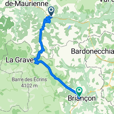
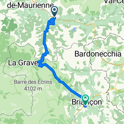
Szablon trasy
Z Saint-Michel-de-Maurienne do Briançon

- 6 h 25 min
- Czas
- 76,5 km
- Dystans
- 3123 m
- Przewyższenia
- 2536 m
- Spadek
- 11,9 km/h
- Śr. Prędkość
- 2634 m
- Maks. wysokość
Settle in for a legendary ride that starts in Saint-Michel-de-Maurienne and winds its way to Briançon—two classic Alpine towns steeped in cycling history. You’ll be tackling about 76.5 km, and with over 3,100 meters of ascent, this is one for the mountain goats!
Right out of Saint-Michel (famous as the gateway to the iconic Col du Galibier), you’ll climb into scenery that’s straight out of Tour de France highlight reels. The route takes you past the dizzying heights of the Alps, with some serious elevation—peaking at over 2,600 meters. Expect a mix of paved and asphalt surfaces, but also be ready for the occasional gravel or unpaved stretch, which keeps things interesting!
You’ll spend most of your time on main and quiet roads, weaving through Alpine meadows and past epic mountain views before a thrilling descent towards Briançon. When you arrive, soak up the vibe of this ancient fortified town—it’s one of Europe’s highest cities, and its ramparts are UNESCO-listed.
Bring your climbing legs, a sense of adventure, and a camera. This route is as challenging as it is unforgettable!
Wspólnota
Najlepsi użytkownicy w tym regionie


Od naszej społeczności
Najlepsze trasy rowerowe z Saint-Michel-de-Maurienne do Briançon

Stäfa - Tarifa Stage #5 Michel de Maurienne - Briancon
Trasa rowerowa w Saint-Michel-de-Maurienne, Owernia-Rodan-Alpy, Francja
- 64,5 km
- Dystans
- 2020 m
- Przewyższenia
- 1540 m
- Spadek

10 tappa traversata delle alpi
Trasa rowerowa w Saint-Michel-de-Maurienne, Owernia-Rodan-Alpy, Francja
- 75,7 km
- Dystans
- 2092 m
- Przewyższenia
- 1625 m
- Spadek

Radreise Ge-Nice-Ledro, St.-Michel-de-Maurienne - Briacon
Trasa rowerowa w Saint-Michel-de-Maurienne, Owernia-Rodan-Alpy, Francja
- 71,9 km
- Dystans
- 2042 m
- Przewyższenia
- 1465 m
- Spadek

RdGA 2022 - Tag 4
Trasa rowerowa w Saint-Michel-de-Maurienne, Owernia-Rodan-Alpy, Francja
- 73,3 km
- Dystans
- 2257 m
- Przewyższenia
- 1753 m
- Spadek

alpes-2012 Telegraphe-Galibiere
Trasa rowerowa w Saint-Michel-de-Maurienne, Owernia-Rodan-Alpy, Francja
- 111,6 km
- Dystans
- 3206 m
- Przewyższenia
- 2653 m
- Spadek

Day 4: Route des Grandes Alpes by BY
Trasa rowerowa w Saint-Michel-de-Maurienne, Owernia-Rodan-Alpy, Francja
- 72,6 km
- Dystans
- 2113 m
- Przewyższenia
- 1488 m
- Spadek

Frankreich 2.2
Trasa rowerowa w Saint-Michel-de-Maurienne, Owernia-Rodan-Alpy, Francja
- 73,7 km
- Dystans
- 2075 m
- Przewyższenia
- 1481 m
- Spadek

Telegraphe, Galibier, Lautaret
Trasa rowerowa w Saint-Michel-de-Maurienne, Owernia-Rodan-Alpy, Francja
- 70,8 km
- Dystans
- 2013 m
- Przewyższenia
- 1514 m
- Spadek

Etapa 5 - Travesia grandes Alpes
Trasa rowerowa w Saint-Michel-de-Maurienne, Owernia-Rodan-Alpy, Francja
- 72,5 km
- Dystans
- 2065 m
- Przewyższenia
- 1568 m
- Spadek

Fra - day 5_1
Trasa rowerowa w Saint-Michel-de-Maurienne, Owernia-Rodan-Alpy, Francja
- 70,6 km
- Dystans
- 2050 m
- Przewyższenia
- 1524 m
- Spadek

CCC Wien - Nizza 2019, 10. Etappe
Trasa rowerowa w Saint-Michel-de-Maurienne, Owernia-Rodan-Alpy, Francja
- 73,1 km
- Dystans
- 2095 m
- Przewyższenia
- 1581 m
- Spadek

Etappe 4 Briancon
Trasa rowerowa w Saint-Michel-de-Maurienne, Owernia-Rodan-Alpy, Francja
- 72,7 km
- Dystans
- 2018 m
- Przewyższenia
- 1435 m
- Spadek
Odkryj więcej tras
 alpes-2012 Telegraphe-Galibiere
- Dystans
- 111,6 km
- Przewyższenia
- 3206 m
- Spadek
- 2653 m
- Lokalizacja
- Saint-Michel-de-Maurienne, Owernia-Rodan-Alpy, Francja
 Day 4: Route des Grandes Alpes by BY
- Dystans
- 72,6 km
- Przewyższenia
- 2113 m
- Spadek
- 1488 m
- Lokalizacja
- Saint-Michel-de-Maurienne, Owernia-Rodan-Alpy, Francja
 Frankreich 2.2
- Dystans
- 73,7 km
- Przewyższenia
- 2075 m
- Spadek
- 1481 m
- Lokalizacja
- Saint-Michel-de-Maurienne, Owernia-Rodan-Alpy, Francja
 Telegraphe, Galibier, Lautaret
- Dystans
- 70,8 km
- Przewyższenia
- 2013 m
- Spadek
- 1514 m
- Lokalizacja
- Saint-Michel-de-Maurienne, Owernia-Rodan-Alpy, Francja
 Etapa 5 - Travesia grandes Alpes
- Dystans
- 72,5 km
- Przewyższenia
- 2065 m
- Spadek
- 1568 m
- Lokalizacja
- Saint-Michel-de-Maurienne, Owernia-Rodan-Alpy, Francja
 Fra - day 5_1
- Dystans
- 70,6 km
- Przewyższenia
- 2050 m
- Spadek
- 1524 m
- Lokalizacja
- Saint-Michel-de-Maurienne, Owernia-Rodan-Alpy, Francja
 CCC Wien - Nizza 2019, 10. Etappe
- Dystans
- 73,1 km
- Przewyższenia
- 2095 m
- Spadek
- 1581 m
- Lokalizacja
- Saint-Michel-de-Maurienne, Owernia-Rodan-Alpy, Francja
 Etappe 4 Briancon
- Dystans
- 72,7 km
- Przewyższenia
- 2018 m
- Spadek
- 1435 m
- Lokalizacja
- Saint-Michel-de-Maurienne, Owernia-Rodan-Alpy, Francja
Trasy z Saint-Michel-de-Maurienne
Jednodniowa wycieczka rowerowa od
Z Saint-Michel-de-Maurienne do Huez
Rowerowa od
Z Saint-Michel-de-Maurienne do Valloire
Trasy do Briançon
Bikepacking od
Z Val d'Isère do Briançon
Jednodniowa wycieczka rowerowa od
Z Huez do Briançon
Jednodniowa wycieczka rowerowa od
Z Modane do Briançon