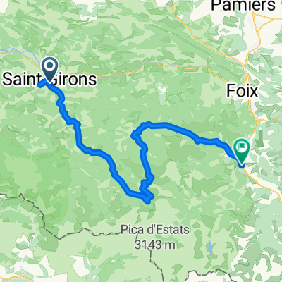


Day 1, 29 May, Castillon - Tarascon
- 87,4 km
- 1919 m
- 1994 m
- Saint-Girons, Occitanie, Francja

Dostosuj własną trasę na podstawie naszego szablonu lub zobacz, jak nasza społeczność najchętniej jeździ z Saint-Girons do Tarascon-sur-Ariège.
Szablon trasy

This cycling route is a real adventure across the Pyrenees, starting in the charming market town of Saint-Girons and winding its way to the historic Tarascon-sur-Ariège. You’ll pedal about 75 km through a mix of rolling countryside, forest tracks, and scenic gravel paths—this isn’t your average paved ride! Prepare for some solid climbing, with nearly 1,800 meters of ascent along the way, reaching elevations around 950 meters.
The first half of the journey is dominated by backcountry gravel and unpaved paths, perfect if you love getting off the beaten track. Don’t forget to soak in the amazing mountain views and maybe spot some wildlife! The route stays mostly quiet, steering clear of traffic—just the way we like it.
Once you arrive, Tarascon-sur-Ariège rewards your efforts with a picturesque old town, Romanesque churches, and a healthy dose of local history. Both towns are gateways to adventure in the Ariège region, making this route a must for anyone who loves a challenge and some seriously beautiful scenery. Bring your gravel bike and plenty of snacks!
Wspólnota
Od naszej społeczności
Trasa rowerowa w Saint-Girons, Occitanie, Francja
Trasa rowerowa w Saint-Girons, Occitanie, Francja
Trasa rowerowa w Saint-Girons, Occitanie, Francja
Trasa rowerowa w Saint-Girons, Occitanie, Francja
Trasa rowerowa w Saint-Girons, Occitanie, Francja
Trasa rowerowa w Saint-Girons, Occitanie, Francja
Trasa rowerowa w Saint-Girons, Occitanie, Francja
Trasa rowerowa w Saint-Girons, Occitanie, Francja
Trasa rowerowa w Saint-Girons, Occitanie, Francja
Trasa rowerowa w Saint-Girons, Occitanie, Francja
Trasa rowerowa w Saint-Girons, Occitanie, Francja
Trasa rowerowa w Saint-Girons, Occitanie, Francja
Jednodniowa wycieczka rowerowa od
Jednodniowa wycieczka rowerowa od