
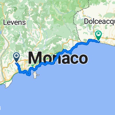
Jednodniowa wycieczka rowerowa z Nicea do Saint-Roman
Dostosuj własną trasę na podstawie naszego szablonu lub zobacz, jak nasza społeczność najchętniej jeździ z Nicea do Saint-Roman.
Szablon trasy
Z Nicea do Saint-Roman

- 2 h 47 min
- Czas
- 30,4 km
- Dystans
- 1472 m
- Przewyższenia
- 1439 m
- Spadek
- 10,9 km/h
- Śr. Prędkość
- 554 m
- Maks. wysokość
Here’s a fantastic route that leads you from the heart of Nice all the way to scenic Saint-Roman—perfect if you’re hungry for a solid climb matched by Mediterranean views.
Starting in Nice, you’ll enjoy the city’s seaside buzz before escaping into the quieter hills northeast. The route is about 30 km and, heads-up, you’ll be doing a serious climb—almost 1,500 meters of ascent! The journey rolls mostly on quiet roads and subtle cycleways, winding through rustic villages and above olive groves. Be sure to pause and look back at the sweeping views over the Bay of Angels.
About two-thirds of the surface is a mix, so be prepared for some gravelly or semi-paved patches—definitely worth it for the peaceful vibe. The approach to Saint-Roman offers a tranquil finish in a picturesque spot tucked into the cliffs above Monaco. If you’ve got some gas left in the tank, grab an espresso or just soak in the panoramic views before heading back.
All in all, it’s a blend of urban charm, classic Riviera scenery, and a rewarding physical challenge!
Wspólnota
Najlepsi użytkownicy w tym regionie


Od naszej społeczności
Najlepsze trasy rowerowe z Nicea do Saint-Roman

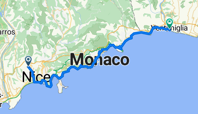
4 Rue Alberti, Nizza nach Via Roma 50D, Ventimiglia
Trasa rowerowa w Nicea, Prowansja-Alpy-Lazurowe Wybrzeże, Francja
- 39 km
- Dystans
- 1595 m
- Przewyższenia
- 1599 m
- Spadek

NICE, MENTON
Trasa rowerowa w Nicea, Prowansja-Alpy-Lazurowe Wybrzeże, Francja
- 32,9 km
- Dystans
- 684 m
- Przewyższenia
- 690 m
- Spadek

Nice / Menton
Trasa rowerowa w Nicea, Prowansja-Alpy-Lazurowe Wybrzeże, Francja
- 41,4 km
- Dystans
- 818 m
- Przewyższenia
- 825 m
- Spadek

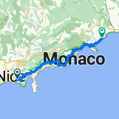
Place de l'Île de Beauté, Nice to Plage du Larvotto, Monaco
Trasa rowerowa w Nicea, Prowansja-Alpy-Lazurowe Wybrzeże, Francja
- 24,2 km
- Dystans
- 687 m
- Przewyższenia
- 690 m
- Spadek

Nice- Bordighera
Trasa rowerowa w Nicea, Prowansja-Alpy-Lazurowe Wybrzeże, Francja
- 48,8 km
- Dystans
- 703 m
- Przewyższenia
- 692 m
- Spadek

BPM: Du Café au Col de Turini
Trasa rowerowa w Nicea, Prowansja-Alpy-Lazurowe Wybrzeże, Francja
- 112,3 km
- Dystans
- 2232 m
- Przewyższenia
- 2227 m
- Spadek

Moyenne Corniche
Trasa rowerowa w Nicea, Prowansja-Alpy-Lazurowe Wybrzeże, Francja
- 27,3 km
- Dystans
- 1121 m
- Przewyższenia
- 1023 m
- Spadek

Nice-Ventimiglia
Trasa rowerowa w Nicea, Prowansja-Alpy-Lazurowe Wybrzeże, Francja
- 47,9 km
- Dystans
- 704 m
- Przewyższenia
- 703 m
- Spadek

Italy 2014 Day 2
Trasa rowerowa w Nicea, Prowansja-Alpy-Lazurowe Wybrzeże, Francja
- 48,4 km
- Dystans
- 674 m
- Przewyższenia
- 658 m
- Spadek
Nice-Vintimille
Trasa rowerowa w Nicea, Prowansja-Alpy-Lazurowe Wybrzeże, Francja
- 47,5 km
- Dystans
- 534 m
- Przewyższenia
- 701 m
- Spadek

Nice - Corniche - Menton
Trasa rowerowa w Nicea, Prowansja-Alpy-Lazurowe Wybrzeże, Francja
- 34,7 km
- Dystans
- 707 m
- Przewyższenia
- 621 m
- Spadek

Nice-Menton
Trasa rowerowa w Nicea, Prowansja-Alpy-Lazurowe Wybrzeże, Francja
- 27,8 km
- Dystans
- 669 m
- Przewyższenia
- 668 m
- Spadek
Odkryj więcej tras
 Nice- Bordighera
- Dystans
- 48,8 km
- Przewyższenia
- 703 m
- Spadek
- 692 m
- Lokalizacja
- Nicea, Prowansja-Alpy-Lazurowe Wybrzeże, Francja
 BPM: Du Café au Col de Turini
- Dystans
- 112,3 km
- Przewyższenia
- 2232 m
- Spadek
- 2227 m
- Lokalizacja
- Nicea, Prowansja-Alpy-Lazurowe Wybrzeże, Francja
 Moyenne Corniche
- Dystans
- 27,3 km
- Przewyższenia
- 1121 m
- Spadek
- 1023 m
- Lokalizacja
- Nicea, Prowansja-Alpy-Lazurowe Wybrzeże, Francja
 Nice-Ventimiglia
- Dystans
- 47,9 km
- Przewyższenia
- 704 m
- Spadek
- 703 m
- Lokalizacja
- Nicea, Prowansja-Alpy-Lazurowe Wybrzeże, Francja
 Italy 2014 Day 2
- Dystans
- 48,4 km
- Przewyższenia
- 674 m
- Spadek
- 658 m
- Lokalizacja
- Nicea, Prowansja-Alpy-Lazurowe Wybrzeże, Francja
 Nice-Vintimille
- Dystans
- 47,5 km
- Przewyższenia
- 534 m
- Spadek
- 701 m
- Lokalizacja
- Nicea, Prowansja-Alpy-Lazurowe Wybrzeże, Francja
 Nice - Corniche - Menton
- Dystans
- 34,7 km
- Przewyższenia
- 707 m
- Spadek
- 621 m
- Lokalizacja
- Nicea, Prowansja-Alpy-Lazurowe Wybrzeże, Francja
 Nice-Menton
- Dystans
- 27,8 km
- Przewyższenia
- 669 m
- Spadek
- 668 m
- Lokalizacja
- Nicea, Prowansja-Alpy-Lazurowe Wybrzeże, Francja
Trasy z Nicea
Szybka przejażdżka rowerowa od
Z Nicea do Villefranche-sur-Mer
Trasy do Saint-Roman
Jednodniowa wycieczka rowerowa od
Z Saint-Martin-Vésubie do Saint-Roman