
Jednodniowa wycieczka rowerowa z Jausiers do Saint-Martin-Vésubie
Dostosuj własną trasę na podstawie naszego szablonu lub zobacz, jak nasza społeczność najchętniej jeździ z Jausiers do Saint-Martin-Vésubie.
Szablon trasy
Z Jausiers do Saint-Martin-Vésubie

- 11 h 16 min
- Czas
- 106,2 km
- Dystans
- 5960 m
- Przewyższenia
- 6215 m
- Spadek
- 9,4 km/h
- Śr. Prędkość
- 2710 m
- Maks. wysokość
Ready for an epic ride? This route takes you from the charming alpine village of Jausiers, tucked in the Ubaye Valley, to the picturesque mountain town of Saint-Martin-Vésubie, known as the "Nice of the Alps." You'll climb over 5,900 meters and descend over 6,200 meters across roughly 106 km—a true test for the legs (and lungs!).
Expect scenery that turns heads: think mountain passes, wildflower-studded meadows, and valleys that drop away dramatically below you. You’ll likely tackle sections of the famous Cime de la Bonette, the highest paved road in France at over 2,700 meters. The route mixes it up with paved roads, gravel paths, and mountain tracks, so you’ll want a bike ready for anything and a taste for adventure.
Finish in Saint-Martin-Vésubie, where you can treat yourself in this gateway to the Mercantour National Park. This isn’t just a ride—it’s a classic high-alpine adventure!
Wspólnota
Najlepsi użytkownicy w tym regionie


Od naszej społeczności
Najlepsze trasy rowerowe z Jausiers do Saint-Martin-Vésubie

Herisau - Nizza 6. Etappe Jausiers-Saint-Martin-Vesubie
Trasa rowerowa w Jausiers, Prowansja-Alpy-Lazurowe Wybrzeże, Francja
- 104,3 km
- Dystans
- 2507 m
- Przewyższenia
- 2762 m
- Spadek

Gersau - Nizza: 7. Etappe
Trasa rowerowa w Jausiers, Prowansja-Alpy-Lazurowe Wybrzeże, Francja
- 79,6 km
- Dystans
- 1553 m
- Przewyższenia
- 2289 m
- Spadek

RdGA 2022 - Tag 6
Trasa rowerowa w Jausiers, Prowansja-Alpy-Lazurowe Wybrzeże, Francja
- 106,3 km
- Dystans
- 2584 m
- Przewyższenia
- 2833 m
- Spadek

Col de la Bonette
Trasa rowerowa w Jausiers, Prowansja-Alpy-Lazurowe Wybrzeże, Francja
- 76 km
- Dystans
- 1534 m
- Przewyższenia
- 2246 m
- Spadek

4. Etappe Route des Grandes Alpes Jausiers - St. Martin -Vesubie
Trasa rowerowa w Jausiers, Prowansja-Alpy-Lazurowe Wybrzeże, Francja
- 106,9 km
- Dystans
- 2510 m
- Przewyższenia
- 2777 m
- Spadek
Variant Jausiers - St Martin Vesubie
Trasa rowerowa w Jausiers, Prowansja-Alpy-Lazurowe Wybrzeże, Francja
- 107,1 km
- Dystans
- 2660 m
- Przewyższenia
- 2925 m
- Spadek

Lange Ausfahrt von Jausiers nach Rimplas
Trasa rowerowa w Jausiers, Prowansja-Alpy-Lazurowe Wybrzeże, Francja
- 83,8 km
- Dystans
- 1563 m
- Przewyższenia
- 2302 m
- Spadek

FA2013_day5:Jausiers-Isola
Trasa rowerowa w Jausiers, Prowansja-Alpy-Lazurowe Wybrzeże, Francja
- 90 km
- Dystans
- 2039 m
- Przewyższenia
- 2271 m
- Spadek

Fr 13.8.2021 Jausiers / Valdeblore
Trasa rowerowa w Jausiers, Prowansja-Alpy-Lazurowe Wybrzeże, Francja
- 91,3 km
- Dystans
- 2087 m
- Przewyższenia
- 2298 m
- Spadek

G-N dag 5a naar St.Saveur sur Tinee
Trasa rowerowa w Jausiers, Prowansja-Alpy-Lazurowe Wybrzeże, Francja
- 82,6 km
- Dystans
- 1979 m
- Przewyższenia
- 2201 m
- Spadek
Jausiers to Roubion
Trasa rowerowa w Jausiers, Prowansja-Alpy-Lazurowe Wybrzeże, Francja
- 88 km
- Dystans
- 2322 m
- Przewyższenia
- 2198 m
- Spadek

G-N dag 5 naar St.Saveur sur Tinee
Trasa rowerowa w Jausiers, Prowansja-Alpy-Lazurowe Wybrzeże, Francja
- 124 km
- Dystans
- 3100 m
- Przewyższenia
- 3322 m
- Spadek
Odkryj więcej tras
 4. Etappe Route des Grandes Alpes Jausiers - St. Martin -Vesubie
- Dystans
- 106,9 km
- Przewyższenia
- 2510 m
- Spadek
- 2777 m
- Lokalizacja
- Jausiers, Prowansja-Alpy-Lazurowe Wybrzeże, Francja
 Variant Jausiers - St Martin Vesubie
- Dystans
- 107,1 km
- Przewyższenia
- 2660 m
- Spadek
- 2925 m
- Lokalizacja
- Jausiers, Prowansja-Alpy-Lazurowe Wybrzeże, Francja
 Lange Ausfahrt von Jausiers nach Rimplas
- Dystans
- 83,8 km
- Przewyższenia
- 1563 m
- Spadek
- 2302 m
- Lokalizacja
- Jausiers, Prowansja-Alpy-Lazurowe Wybrzeże, Francja
 FA2013_day5:Jausiers-Isola
- Dystans
- 90 km
- Przewyższenia
- 2039 m
- Spadek
- 2271 m
- Lokalizacja
- Jausiers, Prowansja-Alpy-Lazurowe Wybrzeże, Francja
 Fr 13.8.2021 Jausiers / Valdeblore
- Dystans
- 91,3 km
- Przewyższenia
- 2087 m
- Spadek
- 2298 m
- Lokalizacja
- Jausiers, Prowansja-Alpy-Lazurowe Wybrzeże, Francja
 G-N dag 5a naar St.Saveur sur Tinee
- Dystans
- 82,6 km
- Przewyższenia
- 1979 m
- Spadek
- 2201 m
- Lokalizacja
- Jausiers, Prowansja-Alpy-Lazurowe Wybrzeże, Francja
 Jausiers to Roubion
- Dystans
- 88 km
- Przewyższenia
- 2322 m
- Spadek
- 2198 m
- Lokalizacja
- Jausiers, Prowansja-Alpy-Lazurowe Wybrzeże, Francja
 G-N dag 5 naar St.Saveur sur Tinee
- Dystans
- 124 km
- Przewyższenia
- 3100 m
- Spadek
- 3322 m
- Lokalizacja
- Jausiers, Prowansja-Alpy-Lazurowe Wybrzeże, Francja
Trasy z Jausiers
Bikepacking od
Z Jausiers do Nicea
Jednodniowa wycieczka rowerowa od
Z Jausiers do Briançon
Trasy do Saint-Martin-Vésubie
Jednodniowa wycieczka rowerowa od
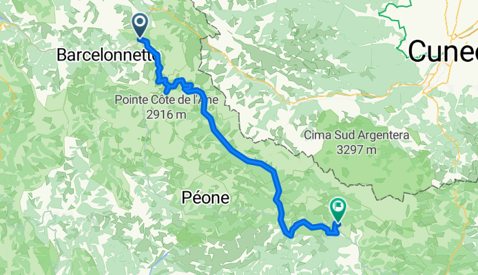
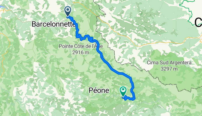
Z Barcelonnette do Saint-Martin-Vésubie
Jednodniowa wycieczka rowerowa od
Z Puget-Théniers do Saint-Martin-Vésubie