
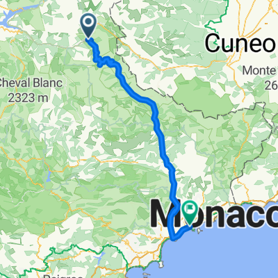
Szablon trasy
Z Jausiers do Nicea

- 21 h 45 min
- Czas
- 212,7 km
- Dystans
- 13 063 m
- Przewyższenia
- 14 259 m
- Spadek
- 9,8 km/h
- Śr. Prędkość
- 2710 m
- Maks. wysokość
Get ready for an epic ride from the mountain village of Jausiers all the way to the sparkling coast of Nice! This route is a true adventure, covering just over 212 km and taking you from the high peaks of the Alps to the Mediterranean Sea.
You’ll start off in Jausiers, a classic gateway for Alpine cycling, especially famous for the nearby Col de la Bonette—one of the highest paved roads in Europe, at over 2700 meters. The first part of the route packs lots of serious climbing, so keep your legs fresh! There’s a wild mix of surfaces: expect a good dose of unpaved and gravel sections, as well as some smooth asphalt on quieter roads.
Scenery-wise, you’re in for a treat: alpine vistas, deep gorges, lush valleys, and, finally, sweeping sea views as you descend toward Nice. About a third of your ride is on tracks and paths, so a gravel or adventure bike will be your best friend.
You’ll finish in Nice, a lively city with famous beaches, gelato, and a well-deserved sense of accomplishment. Don’t forget to have a dip in the sea to celebrate!
Wspólnota
Najlepsi użytkownicy w tym regionie


Od naszej społeczności
Najlepsze trasy rowerowe z Jausiers do Nicea

Day 5a - The High Alps - Jausiers to Nice
Trasa rowerowa w Jausiers, Prowansja-Alpy-Lazurowe Wybrzeże, Francja
- 177,2 km
- Dystans
- 2330 m
- Przewyższenia
- 3577 m
- Spadek

Day 5 - The High Alps - Jausiers to Nice
Trasa rowerowa w Jausiers, Prowansja-Alpy-Lazurowe Wybrzeże, Francja
- 136,2 km
- Dystans
- 1611 m
- Przewyższenia
- 2858 m
- Spadek

Day 5b - The High Alps - Jausiers to Nice
Trasa rowerowa w Jausiers, Prowansja-Alpy-Lazurowe Wybrzeże, Francja
- 190,6 km
- Dystans
- 1277 m
- Przewyższenia
- 2523 m
- Spadek

Kui viimane päev teha 2 päevaliseks
Trasa rowerowa w Jausiers, Prowansja-Alpy-Lazurowe Wybrzeże, Francja
- 213,5 km
- Dystans
- 3544 m
- Przewyższenia
- 4763 m
- Spadek

Genfer See - Cote d'Azur, Jausiers - Nizza (Tag 6)
Trasa rowerowa w Jausiers, Prowansja-Alpy-Lazurowe Wybrzeże, Francja
- 150,1 km
- Dystans
- 1855 m
- Przewyższenia
- 3050 m
- Spadek

Спуск к Ницце
Trasa rowerowa w Jausiers, Prowansja-Alpy-Lazurowe Wybrzeże, Francja
- 118,1 km
- Dystans
- 47 m
- Przewyższenia
- 2820 m
- Spadek

13. E Wien-Nizza
Trasa rowerowa w Jausiers, Prowansja-Alpy-Lazurowe Wybrzeże, Francja
- 139,8 km
- Dystans
- 1727 m
- Przewyższenia
- 2967 m
- Spadek

Tag 9. Jausiers - Nizza
Trasa rowerowa w Jausiers, Prowansja-Alpy-Lazurowe Wybrzeże, Francja
- 131,8 km
- Dystans
- 1539 m
- Przewyższenia
- 2749 m
- Spadek

BikeAlp - day16
Trasa rowerowa w Jausiers, Prowansja-Alpy-Lazurowe Wybrzeże, Francja
- 146,3 km
- Dystans
- 1595 m
- Przewyższenia
- 2823 m
- Spadek

Jausiers to Nice (Via Col de la Bonette)
Trasa rowerowa w Jausiers, Prowansja-Alpy-Lazurowe Wybrzeże, Francja
- 137,6 km
- Dystans
- 1588 m
- Przewyższenia
- 2796 m
- Spadek

CCC Wien - Nizza 2019, 13. Etappe
Trasa rowerowa w Jausiers, Prowansja-Alpy-Lazurowe Wybrzeże, Francja
- 140,7 km
- Dystans
- 1645 m
- Przewyższenia
- 2885 m
- Spadek

Alternative nach Nizza
Trasa rowerowa w Jausiers, Prowansja-Alpy-Lazurowe Wybrzeże, Francja
- 174,5 km
- Dystans
- 4041 m
- Przewyższenia
- 5249 m
- Spadek
Odkryj więcej tras
 Genfer See - Cote d'Azur, Jausiers - Nizza (Tag 6)
- Dystans
- 150,1 km
- Przewyższenia
- 1855 m
- Spadek
- 3050 m
- Lokalizacja
- Jausiers, Prowansja-Alpy-Lazurowe Wybrzeże, Francja
 Спуск к Ницце
- Dystans
- 118,1 km
- Przewyższenia
- 47 m
- Spadek
- 2820 m
- Lokalizacja
- Jausiers, Prowansja-Alpy-Lazurowe Wybrzeże, Francja
 13. E Wien-Nizza
- Dystans
- 139,8 km
- Przewyższenia
- 1727 m
- Spadek
- 2967 m
- Lokalizacja
- Jausiers, Prowansja-Alpy-Lazurowe Wybrzeże, Francja
 Tag 9. Jausiers - Nizza
- Dystans
- 131,8 km
- Przewyższenia
- 1539 m
- Spadek
- 2749 m
- Lokalizacja
- Jausiers, Prowansja-Alpy-Lazurowe Wybrzeże, Francja
 BikeAlp - day16
- Dystans
- 146,3 km
- Przewyższenia
- 1595 m
- Spadek
- 2823 m
- Lokalizacja
- Jausiers, Prowansja-Alpy-Lazurowe Wybrzeże, Francja
 Jausiers to Nice (Via Col de la Bonette)
- Dystans
- 137,6 km
- Przewyższenia
- 1588 m
- Spadek
- 2796 m
- Lokalizacja
- Jausiers, Prowansja-Alpy-Lazurowe Wybrzeże, Francja
 CCC Wien - Nizza 2019, 13. Etappe
- Dystans
- 140,7 km
- Przewyższenia
- 1645 m
- Spadek
- 2885 m
- Lokalizacja
- Jausiers, Prowansja-Alpy-Lazurowe Wybrzeże, Francja
 Alternative nach Nizza
- Dystans
- 174,5 km
- Przewyższenia
- 4041 m
- Spadek
- 5249 m
- Lokalizacja
- Jausiers, Prowansja-Alpy-Lazurowe Wybrzeże, Francja
Trasy z Jausiers
Jednodniowa wycieczka rowerowa od
Z Jausiers do Briançon
Jednodniowa wycieczka rowerowa od
Z Jausiers do Saint-Martin-Vésubie
Trasy do Nicea
Jednodniowa wycieczka rowerowa od
Z Saint-Martin-Vésubie do Nicea
Jednodniowa wycieczka rowerowa od
Z Saint-Roman do Nicea
Rowerowa od
Z Saint-Laurent-du-Var do Nicea
Rowerowa od
Z Villefranche-sur-Mer do Nicea