
Jednodniowa wycieczka rowerowa z Huez do Saint-Michel-de-Maurienne
Dostosuj własną trasę na podstawie naszego szablonu lub zobacz, jak nasza społeczność najchętniej jeździ z Huez do Saint-Michel-de-Maurienne.
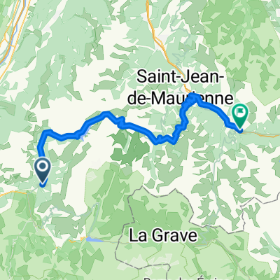
Szablon trasy
Z Huez do Saint-Michel-de-Maurienne

- 9 h 4 min
- Czas
- 75,1 km
- Dystans
- 3195 m
- Przewyższenia
- 3980 m
- Spadek
- 8,3 km/h
- Śr. Prędkość
- 2469 m
- Maks. wysokość
Ready for an epic ride in the French Alps? Set off from the famous cycling hotspot of Huez—home to the legendary Alpe d’Huez climb, a Mecca for Tour de France fans—and get ready to cross some serious mountain terrain! This challenging route will take you roughly 75 km, with over 3,100 meters of climbing and nearly 4,000 meters of exhilarating descents. Expect dramatic alpine views as you wind between peaceful roads, stretches of paved asphalt, and a few adventure-inspiring sections where the surface is less certain (so be ready for anything!).
After conquering high mountain passes (topping out at nearly 2,500 meters!), you’ll descend into Saint-Michel-de-Maurienne, a charming little town known as a gateway to cycling legends like the Col du Galibier. Just be prepared: this route is not for the faint of heart, but it’ll definitely earn you some bragging rights—and maybe a good pastry at your finish!
Wspólnota
Najlepsi użytkownicy w tym regionie


Od naszej społeczności
Najlepsze trasy rowerowe z Huez do Saint-Michel-de-Maurienne

Huez Village-Galibier-Col de Telegraphe-St. Jean de Maurienne
Trasa rowerowa w Huez, Owernia-Rodan-Alpy, Francja
- 91,9 km
- Dystans
- 2189 m
- Przewyższenia
- 2942 m
- Spadek

Bourg Oisans - St Michel 80km
Trasa rowerowa w Huez, Owernia-Rodan-Alpy, Francja
- 84,1 km
- Dystans
- 1693 m
- Przewyższenia
- 1680 m
- Spadek

Francia 2018-3 Le Bourg-d'Oisans-Saint-Michel de Maurienne
Trasa rowerowa w Huez, Owernia-Rodan-Alpy, Francja
- 98,4 km
- Dystans
- 2032 m
- Przewyższenia
- 2031 m
- Spadek

Galibier & Telegraphe
Trasa rowerowa w Huez, Owernia-Rodan-Alpy, Francja
- 71,1 km
- Dystans
- 2468 m
- Przewyższenia
- 1610 m
- Spadek

Stage 3
Trasa rowerowa w Huez, Owernia-Rodan-Alpy, Francja
- 82,3 km
- Dystans
- 2105 m
- Przewyższenia
- 2804 m
- Spadek

Tag 2 Glandon + la Croix de Fer + Mollard
Trasa rowerowa w Huez, Owernia-Rodan-Alpy, Francja
- 93,2 km
- Dystans
- 1762 m
- Przewyższenia
- 2834 m
- Spadek

galibier
Trasa rowerowa w Huez, Owernia-Rodan-Alpy, Francja
- 81,8 km
- Dystans
- 2149 m
- Przewyższenia
- 2155 m
- Spadek

Stage 2 - Col de la Croix de Fer
Trasa rowerowa w Huez, Owernia-Rodan-Alpy, Francja
- 69 km
- Dystans
- 1741 m
- Przewyższenia
- 1732 m
- Spadek

5. Tag Bourg d' Oisans - Saint-Michel-de-Maurienne
Trasa rowerowa w Huez, Owernia-Rodan-Alpy, Francja
- 82,1 km
- Dystans
- 2048 m
- Przewyższenia
- 2055 m
- Spadek

Stage 2a - Mollard variant
Trasa rowerowa w Huez, Owernia-Rodan-Alpy, Francja
- 79,9 km
- Dystans
- 1996 m
- Przewyższenia
- 1987 m
- Spadek

Col du Glandon / Croix de Fer
Trasa rowerowa w Huez, Owernia-Rodan-Alpy, Francja
- 80,4 km
- Dystans
- 1688 m
- Przewyższenia
- 1705 m
- Spadek

Day 6 - Alpe d'Huez to Saint-Michel-de-Maurienne - 171 Km / 4,609 m
Trasa rowerowa w Huez, Owernia-Rodan-Alpy, Francja
- 171,8 km
- Dystans
- 6352 m
- Przewyższenia
- 7458 m
- Spadek
Odkryj więcej tras
 Stage 3
- Dystans
- 82,3 km
- Przewyższenia
- 2105 m
- Spadek
- 2804 m
- Lokalizacja
- Huez, Owernia-Rodan-Alpy, Francja
 Tag 2 Glandon + la Croix de Fer + Mollard
- Dystans
- 93,2 km
- Przewyższenia
- 1762 m
- Spadek
- 2834 m
- Lokalizacja
- Huez, Owernia-Rodan-Alpy, Francja
 galibier
- Dystans
- 81,8 km
- Przewyższenia
- 2149 m
- Spadek
- 2155 m
- Lokalizacja
- Huez, Owernia-Rodan-Alpy, Francja
 Stage 2 - Col de la Croix de Fer
- Dystans
- 69 km
- Przewyższenia
- 1741 m
- Spadek
- 1732 m
- Lokalizacja
- Huez, Owernia-Rodan-Alpy, Francja
 5. Tag Bourg d' Oisans - Saint-Michel-de-Maurienne
- Dystans
- 82,1 km
- Przewyższenia
- 2048 m
- Spadek
- 2055 m
- Lokalizacja
- Huez, Owernia-Rodan-Alpy, Francja
 Stage 2a - Mollard variant
- Dystans
- 79,9 km
- Przewyższenia
- 1996 m
- Spadek
- 1987 m
- Lokalizacja
- Huez, Owernia-Rodan-Alpy, Francja
 Col du Glandon / Croix de Fer
- Dystans
- 80,4 km
- Przewyższenia
- 1688 m
- Spadek
- 1705 m
- Lokalizacja
- Huez, Owernia-Rodan-Alpy, Francja
 Day 6 - Alpe d'Huez to Saint-Michel-de-Maurienne - 171 Km / 4,609 m
- Dystans
- 171,8 km
- Przewyższenia
- 6352 m
- Spadek
- 7458 m
- Lokalizacja
- Huez, Owernia-Rodan-Alpy, Francja
Trasy z Huez
Jednodniowa wycieczka rowerowa od
Z Huez do Les Deux Alpes
Jednodniowa wycieczka rowerowa od
Z Huez do Saint-Jean-de-Maurienne
Trasy do Saint-Michel-de-Maurienne
Jednodniowa wycieczka rowerowa od
Z Bourg-Saint-Maurice do Saint-Michel-de-Maurienne