
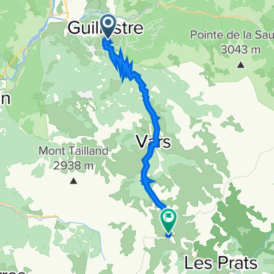
Jednodniowa wycieczka rowerowa z Guillestre do Jausiers
Dostosuj własną trasę na podstawie naszego szablonu lub zobacz, jak nasza społeczność najchętniej jeździ z Guillestre do Jausiers.
Szablon trasy
Z Guillestre do Jausiers

- 4 h 37 min
- Czas
- 51,8 km
- Dystans
- 2733 m
- Przewyższenia
- 2522 m
- Spadek
- 11,2 km/h
- Śr. Prędkość
- 2108 m
- Maks. wysokość
Ready for a big day out in the Alps? This route takes you from the lively town of Guillestre—a gateway to the Queyras and known for its fortifications—down to the picturesque Jausiers, hidden at the base of legendary mountain passes. You’ll cover just under 52 km, but don’t be fooled by the distance: there’s serious climbing on the menu, topping out above 2100 meters!
The ride is a real mixed bag: you’ll spin along busy roads out of town, mellow out on quiet country lanes, and bounce through stretches of gravel and track—bring a bike that can handle a little rough stuff. Expect to cross wild alpine landscapes, with jaw-dropping views and maybe even some marmot sightings.
Both Guillestre and Jausiers make great spots to fuel up or unwind post-ride. If you fancy a detour, the famous Col de Vars or even the mythical Col de la Bonette are right on your doorstep in Jausiers. This is classic Hautes-Alpes cycling—challenging, beautiful, and full of adventure!
Wspólnota
Najlepsi użytkownicy w tym regionie


Od naszej społeczności
Najlepsze trasy rowerowe z Guillestre do Jausiers
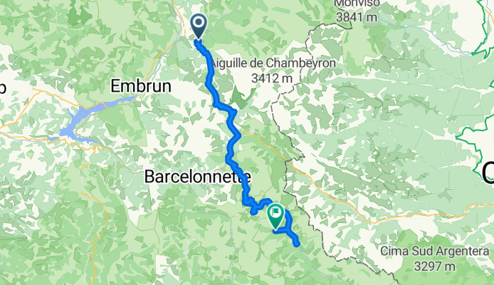
20,21) Col de Vars - 2109 m. + Cime de la Bonette - 2802 m.
Trasa rowerowa w Guillestre, Prowansja-Alpy-Lazurowe Wybrzeże, Francja
- 97,7 km
- Dystans
- 2903 m
- Przewyższenia
- 2448 m
- Spadek

RDGA-05 - Château Queyras - Jausiers
Trasa rowerowa w Guillestre, Prowansja-Alpy-Lazurowe Wybrzeże, Francja
- 126,6 km
- Dystans
- 4082 m
- Przewyższenia
- 4219 m
- Spadek

Grande Routes des Alpes-Guillestre-Jausiers
Trasa rowerowa w Guillestre, Prowansja-Alpy-Lazurowe Wybrzeże, Francja
- 42,1 km
- Dystans
- 1132 m
- Przewyższenia
- 968 m
- Spadek

Etape 8a - Route grands Alpes
Trasa rowerowa w Guillestre, Prowansja-Alpy-Lazurowe Wybrzeże, Francja
- 41,3 km
- Dystans
- 1109 m
- Przewyższenia
- 904 m
- Spadek

ESJ2015_ALPES_JOUR1
Trasa rowerowa w Guillestre, Prowansja-Alpy-Lazurowe Wybrzeże, Francja
- 48,4 km
- Dystans
- 1722 m
- Przewyższenia
- 800 m
- Spadek

Guillestre - Col de Vars - Col de la Bonette
Trasa rowerowa w Guillestre, Prowansja-Alpy-Lazurowe Wybrzeże, Francja
- 63,3 km
- Dystans
- 2598 m
- Przewyższenia
- 904 m
- Spadek

Guillestre - Jausiers
Trasa rowerowa w Guillestre, Prowansja-Alpy-Lazurowe Wybrzeże, Francja
- 163 km
- Dystans
- 4310 m
- Przewyższenia
- 4066 m
- Spadek

Guillestre-Jausiers
Trasa rowerowa w Guillestre, Prowansja-Alpy-Lazurowe Wybrzeże, Francja
- 41,4 km
- Dystans
- 1097 m
- Przewyższenia
- 894 m
- Spadek

Col de Vars
Trasa rowerowa w Guillestre, Prowansja-Alpy-Lazurowe Wybrzeże, Francja
- 20,1 km
- Dystans
- 1159 m
- Przewyższenia
- 46 m
- Spadek

T2012-E4
Trasa rowerowa w Guillestre, Prowansja-Alpy-Lazurowe Wybrzeże, Francja
- 80,4 km
- Dystans
- 2619 m
- Przewyższenia
- 1896 m
- Spadek

Col de Vars
Trasa rowerowa w Guillestre, Prowansja-Alpy-Lazurowe Wybrzeże, Francja
- 19,6 km
- Dystans
- 1155 m
- Przewyższenia
- 82 m
- Spadek

LGA5
Trasa rowerowa w Guillestre, Prowansja-Alpy-Lazurowe Wybrzeże, Francja
- 29,2 km
- Dystans
- 1098 m
- Przewyższenia
- 726 m
- Spadek
Odkryj więcej tras
 ESJ2015_ALPES_JOUR1
- Dystans
- 48,4 km
- Przewyższenia
- 1722 m
- Spadek
- 800 m
- Lokalizacja
- Guillestre, Prowansja-Alpy-Lazurowe Wybrzeże, Francja
 Guillestre - Col de Vars - Col de la Bonette
- Dystans
- 63,3 km
- Przewyższenia
- 2598 m
- Spadek
- 904 m
- Lokalizacja
- Guillestre, Prowansja-Alpy-Lazurowe Wybrzeże, Francja
 Guillestre - Jausiers
- Dystans
- 163 km
- Przewyższenia
- 4310 m
- Spadek
- 4066 m
- Lokalizacja
- Guillestre, Prowansja-Alpy-Lazurowe Wybrzeże, Francja
 Guillestre-Jausiers
- Dystans
- 41,4 km
- Przewyższenia
- 1097 m
- Spadek
- 894 m
- Lokalizacja
- Guillestre, Prowansja-Alpy-Lazurowe Wybrzeże, Francja
 Col de Vars
- Dystans
- 20,1 km
- Przewyższenia
- 1159 m
- Spadek
- 46 m
- Lokalizacja
- Guillestre, Prowansja-Alpy-Lazurowe Wybrzeże, Francja
 T2012-E4
- Dystans
- 80,4 km
- Przewyższenia
- 2619 m
- Spadek
- 1896 m
- Lokalizacja
- Guillestre, Prowansja-Alpy-Lazurowe Wybrzeże, Francja
 Col de Vars
- Dystans
- 19,6 km
- Przewyższenia
- 1155 m
- Spadek
- 82 m
- Lokalizacja
- Guillestre, Prowansja-Alpy-Lazurowe Wybrzeże, Francja
 LGA5
LGA5- Dystans
- 29,2 km
- Przewyższenia
- 1098 m
- Spadek
- 726 m
- Lokalizacja
- Guillestre, Prowansja-Alpy-Lazurowe Wybrzeże, Francja
Trasy z Guillestre
Jednodniowa wycieczka rowerowa od
Z Guillestre do Huez
Jednodniowa wycieczka rowerowa od
Z Guillestre do Barcelonnette
Trasy do Jausiers
Jednodniowa wycieczka rowerowa od
Z Briançon do Jausiers
Rowerowa od
Z Barcelonnette do Jausiers