
Jednodniowa wycieczka rowerowa z Briançon do Guillestre
Dostosuj własną trasę na podstawie naszego szablonu lub zobacz, jak nasza społeczność najchętniej jeździ z Briançon do Guillestre.
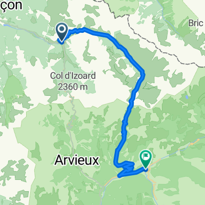
Szablon trasy
Z Briançon do Guillestre

- 4 h 54 min
- Czas
- 48,3 km
- Dystans
- 2170 m
- Przewyższenia
- 2470 m
- Spadek
- 9,9 km/h
- Śr. Prędkość
- 1551 m
- Maks. wysokość
Get ready for a serious Alpine adventure riding from Briançon to Guillestre! Your journey starts in Briançon, Europe’s highest city, famed for its Vauban fortifications and charming old town vibes. From here, you’ll head south into the heart of the French Alps for about 48 km, taking on over 2,100 meters of climbing—so give those legs a pep talk.
This ride delivers everything from winding quiet mountain roads to stretches of gravel and unpaved tracks (good idea to bring a sturdy bike and maybe extra snacks). You’re never far from jaw-dropping scenery: think snow-capped peaks, crisp pine forests, and classic Alpine villages. Most of the way is on peaceful roads and tracks, with the occasional busier stretch—just enough to remind you civilization isn’t far.
You’ll finish in Guillestre, a laid-back gateway town nestled at the confluence of the Guil and Durance rivers, surrounded by dramatic cliffs and mountain backdrops. If you time it right, you can celebrate with some local cheese in a sunny square—well deserved!
Wspólnota
Najlepsi użytkownicy w tym regionie


Od naszej społeczności
Najlepsze trasy rowerowe z Briançon do Guillestre

Francia Alpok negyedik nap vándor nehéz
Trasa rowerowa w Briançon, Prowansja-Alpy-Lazurowe Wybrzeże, Francja
- 112,4 km
- Dystans
- 2451 m
- Przewyższenia
- 2851 m
- Spadek

IZOARD
Trasa rowerowa w Briançon, Prowansja-Alpy-Lazurowe Wybrzeże, Francja
- 53,8 km
- Dystans
- 1794 m
- Przewyższenia
- 1993 m
- Spadek

Alpentour 2009
Trasa rowerowa w Briançon, Prowansja-Alpy-Lazurowe Wybrzeże, Francja
- 57,7 km
- Dystans
- 2027 m
- Przewyższenia
- 2236 m
- Spadek

Boucle de l’Izoard: Briancon - Mont Dauphine
Trasa rowerowa w Briançon, Prowansja-Alpy-Lazurowe Wybrzeże, Francja
- 42,9 km
- Dystans
- 1352 m
- Przewyższenia
- 1527 m
- Spadek

F/5 Briancon_Vars
Trasa rowerowa w Briançon, Prowansja-Alpy-Lazurowe Wybrzeże, Francja
- 61,9 km
- Dystans
- 1861 m
- Przewyższenia
- 1480 m
- Spadek

Alpes II
Trasa rowerowa w Briançon, Prowansja-Alpy-Lazurowe Wybrzeże, Francja
- 101,1 km
- Dystans
- 2539 m
- Przewyższenia
- 2539 m
- Spadek

Col de l'Izoard
Trasa rowerowa w Briançon, Prowansja-Alpy-Lazurowe Wybrzeże, Francja
- 50,8 km
- Dystans
- 2331 m
- Przewyższenia
- 2336 m
- Spadek

19) Col d'Izoard - 2360 m.
Trasa rowerowa w Briançon, Prowansja-Alpy-Lazurowe Wybrzeże, Francja
- 49,8 km
- Dystans
- 1206 m
- Przewyższenia
- 1348 m
- Spadek

Briancon-Col du Angel-Guillestre
Trasa rowerowa w Briançon, Prowansja-Alpy-Lazurowe Wybrzeże, Francja
- 105,8 km
- Dystans
- 2634 m
- Przewyższenia
- 2876 m
- Spadek

RDGA 5
Trasa rowerowa w Briançon, Prowansja-Alpy-Lazurowe Wybrzeże, Francja
- 61 km
- Dystans
- 1803 m
- Przewyższenia
- 1370 m
- Spadek

2.2-TNR2017
Trasa rowerowa w Briançon, Prowansja-Alpy-Lazurowe Wybrzeże, Francja
- 31,1 km
- Dystans
- 1079 m
- Przewyższenia
- 1307 m
- Spadek

Briançon - Guillestre
Trasa rowerowa w Briançon, Prowansja-Alpy-Lazurowe Wybrzeże, Francja
- 50,9 km
- Dystans
- 1397 m
- Przewyższenia
- 1457 m
- Spadek
Odkryj więcej tras
 F/5 Briancon_Vars
- Dystans
- 61,9 km
- Przewyższenia
- 1861 m
- Spadek
- 1480 m
- Lokalizacja
- Briançon, Prowansja-Alpy-Lazurowe Wybrzeże, Francja
 Alpes II
- Dystans
- 101,1 km
- Przewyższenia
- 2539 m
- Spadek
- 2539 m
- Lokalizacja
- Briançon, Prowansja-Alpy-Lazurowe Wybrzeże, Francja
 Col de l'Izoard
- Dystans
- 50,8 km
- Przewyższenia
- 2331 m
- Spadek
- 2336 m
- Lokalizacja
- Briançon, Prowansja-Alpy-Lazurowe Wybrzeże, Francja
 19) Col d'Izoard - 2360 m.
- Dystans
- 49,8 km
- Przewyższenia
- 1206 m
- Spadek
- 1348 m
- Lokalizacja
- Briançon, Prowansja-Alpy-Lazurowe Wybrzeże, Francja
 Briancon-Col du Angel-Guillestre
- Dystans
- 105,8 km
- Przewyższenia
- 2634 m
- Spadek
- 2876 m
- Lokalizacja
- Briançon, Prowansja-Alpy-Lazurowe Wybrzeże, Francja
 RDGA 5
- Dystans
- 61 km
- Przewyższenia
- 1803 m
- Spadek
- 1370 m
- Lokalizacja
- Briançon, Prowansja-Alpy-Lazurowe Wybrzeże, Francja
 2.2-TNR2017
- Dystans
- 31,1 km
- Przewyższenia
- 1079 m
- Spadek
- 1307 m
- Lokalizacja
- Briançon, Prowansja-Alpy-Lazurowe Wybrzeże, Francja
 Briançon - Guillestre
- Dystans
- 50,9 km
- Przewyższenia
- 1397 m
- Spadek
- 1457 m
- Lokalizacja
- Briançon, Prowansja-Alpy-Lazurowe Wybrzeże, Francja
Trasy z Briançon
Jednodniowa wycieczka rowerowa od
Z Briançon do Huez
Jednodniowa wycieczka rowerowa od
Z Briançon do Barcelonnette
Rowerowa od
Z Briançon do Le Monêtier-les-Bains
Rowerowa od
Z Briançon do Villeneuve
Trasy do Guillestre
Jednodniowa wycieczka rowerowa od
Z Valloire do Guillestre