
Rowerowa z Bourg-Saint-Maurice do Séez
Dostosuj własną trasę na podstawie naszego szablonu lub zobacz, jak nasza społeczność najchętniej jeździ z Bourg-Saint-Maurice do Séez.
Szablon trasy
Z Bourg-Saint-Maurice do Séez

- 16 min
- Czas
- 4,3 km
- Dystans
- 86 m
- Przewyższenia
- 33 m
- Spadek
- 16 km/h
- Śr. Prędkość
- 884 m
- Maks. wysokość
Here’s a sweet little spin in the French Alps: Start out in Bourg-Saint-Maurice, a lively mountain town known for its access to world-class ski resorts and the scenic Vanoise National Park. You’ll roll out mostly on smooth asphalt and quiet cycleways, so it’s a chill ride. Expect a light climb—about 86 meters up, so you’ll feel it but it won’t knock you out.
It’s only about 4.3 km to Séez, your finish. Séez is a cozy alpine village perched at just under 900 meters elevation. It’s a peaceful spot and a perfect place to take a break, maybe grab a pastry at a café. Most of your ride keeps you off the busy roads with a good mix of dedicated cycle paths and quiet streets, though a short stretch cuts through a pedestrian area. Enjoy the fresh mountain air—and don’t forget to look up at the surrounding peaks!
Wspólnota
Najlepsi użytkownicy w tym regionie


Od naszej społeczności
Najlepsze trasy rowerowe z Bourg-Saint-Maurice do Séez

Day 8 - Bourg Saint Maurice, Iseran - 94 Km / 2300 m
Trasa rowerowa w Bourg-Saint-Maurice, Owernia-Rodan-Alpy, Francja
- 94,2 km
- Dystans
- 2989 m
- Przewyższenia
- 2990 m
- Spadek

Hot Wheels
Trasa rowerowa w Bourg-Saint-Maurice, Owernia-Rodan-Alpy, Francja
- 12,4 km
- Dystans
- 492 m
- Przewyższenia
- 496 m
- Spadek

Col de la Chal - Col de la Chal
Trasa rowerowa w Bourg-Saint-Maurice, Owernia-Rodan-Alpy, Francja
- 41,6 km
- Dystans
- 2185 m
- Przewyższenia
- 865 m
- Spadek

zebulonsavonne
Trasa rowerowa w Bourg-Saint-Maurice, Owernia-Rodan-Alpy, Francja
- 20,6 km
- Dystans
- 1211 m
- Przewyższenia
- 43 m
- Spadek

BOUR ST MAURICE _ LA ROSIERE
Trasa rowerowa w Bourg-Saint-Maurice, Owernia-Rodan-Alpy, Francja
- 22,4 km
- Dystans
- 1075 m
- Przewyższenia
- 54 m
- Spadek

Chez nous to Rte 66
Trasa rowerowa w Bourg-Saint-Maurice, Owernia-Rodan-Alpy, Francja
- 7,5 km
- Dystans
- 267 m
- Przewyższenia
- 201 m
- Spadek

BOURG ST MAURICE - STE FOY TARENTAISE
Trasa rowerowa w Bourg-Saint-Maurice, Owernia-Rodan-Alpy, Francja
- 11,5 km
- Dystans
- 375 m
- Przewyższenia
- 160 m
- Spadek

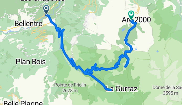
27 - 20 - Bourg-Saint-Maurice - Arc 2000 - ITT
Trasa rowerowa w Bourg-Saint-Maurice, Owernia-Rodan-Alpy, Francja
- 26,8 km
- Dystans
- 1322 m
- Przewyższenia
- 52 m
- Spadek

Montee d'Hauteville
Trasa rowerowa w Bourg-Saint-Maurice, Owernia-Rodan-Alpy, Francja
- 25 km
- Dystans
- 807 m
- Przewyższenia
- 620 m
- Spadek

3. nap La Rosiére
Trasa rowerowa w Bourg-Saint-Maurice, Owernia-Rodan-Alpy, Francja
- 19,2 km
- Dystans
- 1039 m
- Przewyższenia
- 0 m
- Spadek
Col de la Chal - Col de la Chal
Trasa rowerowa w Bourg-Saint-Maurice, Owernia-Rodan-Alpy, Francja
- 45 km
- Dystans
- 2141 m
- Przewyższenia
- 821 m
- Spadek

arc 2000 (2)
Trasa rowerowa w Bourg-Saint-Maurice, Owernia-Rodan-Alpy, Francja
- 24,2 km
- Dystans
- 1481 m
- Przewyższenia
- 186 m
- Spadek
Odkryj więcej tras
 BOUR ST MAURICE _ LA ROSIERE
- Dystans
- 22,4 km
- Przewyższenia
- 1075 m
- Spadek
- 54 m
- Lokalizacja
- Bourg-Saint-Maurice, Owernia-Rodan-Alpy, Francja
 Chez nous to Rte 66
- Dystans
- 7,5 km
- Przewyższenia
- 267 m
- Spadek
- 201 m
- Lokalizacja
- Bourg-Saint-Maurice, Owernia-Rodan-Alpy, Francja
 BOURG ST MAURICE - STE FOY TARENTAISE
- Dystans
- 11,5 km
- Przewyższenia
- 375 m
- Spadek
- 160 m
- Lokalizacja
- Bourg-Saint-Maurice, Owernia-Rodan-Alpy, Francja
 27 - 20 - Bourg-Saint-Maurice - Arc 2000 - ITT
- Dystans
- 26,8 km
- Przewyższenia
- 1322 m
- Spadek
- 52 m
- Lokalizacja
- Bourg-Saint-Maurice, Owernia-Rodan-Alpy, Francja
 Montee d'Hauteville
- Dystans
- 25 km
- Przewyższenia
- 807 m
- Spadek
- 620 m
- Lokalizacja
- Bourg-Saint-Maurice, Owernia-Rodan-Alpy, Francja
 3. nap La Rosiére
- Dystans
- 19,2 km
- Przewyższenia
- 1039 m
- Spadek
- 0 m
- Lokalizacja
- Bourg-Saint-Maurice, Owernia-Rodan-Alpy, Francja
 Col de la Chal - Col de la Chal
- Dystans
- 45 km
- Przewyższenia
- 2141 m
- Spadek
- 821 m
- Lokalizacja
- Bourg-Saint-Maurice, Owernia-Rodan-Alpy, Francja
 arc 2000 (2)
- Dystans
- 24,2 km
- Przewyższenia
- 1481 m
- Spadek
- 186 m
- Lokalizacja
- Bourg-Saint-Maurice, Owernia-Rodan-Alpy, Francja
Trasy z Bourg-Saint-Maurice
Jednodniowa wycieczka rowerowa od
Z Bourg-Saint-Maurice do Modane
Jednodniowa wycieczka rowerowa od
Z Bourg-Saint-Maurice do Val d'Isère