
Bikepacking z Bagnères-de-Luchon do Bajonna
Dostosuj własną trasę na podstawie naszego szablonu lub zobacz, jak nasza społeczność najchętniej jeździ z Bagnères-de-Luchon do Bajonna.
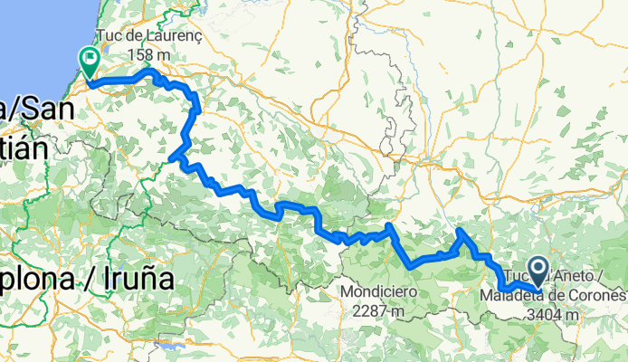
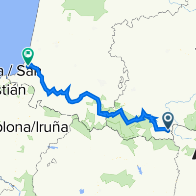
Szablon trasy
Z Bagnères-de-Luchon do Bajonna

- 37 h
- Czas
- 675,5 km
- Dystans
- 3224 m
- Przewyższenia
- 3832 m
- Spadek
- 18,3 km/h
- Śr. Prędkość
- 691 m
- Maks. wysokość
This ride takes you from the spa town of Bagnères-de-Luchon, nestled in the heart of the Pyrenees, all the way to the Atlantic vibe of Bayonne. The journey spans a whopping 675 km, mixing up plenty of smooth cycleways (about two-thirds of the ride!) with peaceful backroads and a touch of gravel here and there—perfect for touring bikes and adventurous spirits.
Starting in Luchon, famed for its thermal waters and as a regular stage town in the Tour de France, you’ll climb through lush mountain scenery and eventually descend towards rolling hills and wide vistas as you approach coastal Basque country. Don’t let the numbers scare you—the climbs are balanced with ample descents (almost 3,800 meters down!), and the ride eventually delivers you into Bayonne. Once you arrive, soak up the blend of French and Basque culture, with its famous chocolate shops and half-timbered houses lining the Nive River.
Whether you’re chasing Pyrenean mountain air or Atlantic sea breezes, it’s an epic ride—just bring plenty of snacks and take it at your own pace!
Wspólnota
Najlepsi użytkownicy w tym regionie


Od naszej społeczności
Najlepsze trasy rowerowe z Bagnères-de-Luchon do Bajonna


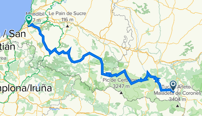
20180622 LUCHON BAYONNE
Trasa rowerowa w Bagnères-de-Luchon, Occitanie, Francja
- 321,4 km
- Dystans
- 4211 m
- Przewyższenia
- 4835 m
- Spadek

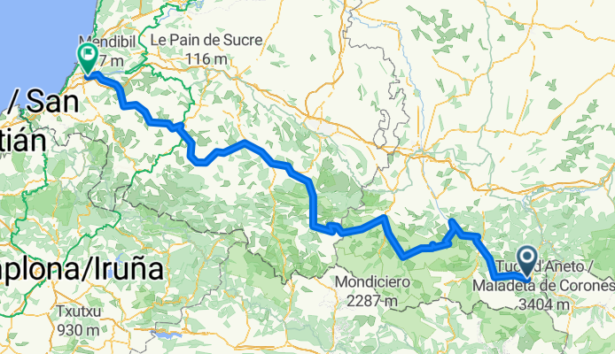
LB2010
Trasa rowerowa w Bagnères-de-Luchon, Occitanie, Francja
- 318,2 km
- Dystans
- 4302 m
- Przewyższenia
- 4929 m
- Spadek

Stage 23: The Birth of a Pyrenean Classic
Trasa rowerowa w Bagnères-de-Luchon, Occitanie, Francja
- 325 km
- Dystans
- 4393 m
- Przewyższenia
- 5024 m
- Spadek

Ultimate Étapes, Stage 23: The Birth of a Pyrenean Classic
Trasa rowerowa w Bagnères-de-Luchon, Occitanie, Francja
- 317,2 km
- Dystans
- 4408 m
- Przewyższenia
- 5039 m
- Spadek

LuchonBayonne
Trasa rowerowa w Bagnères-de-Luchon, Occitanie, Francja
- 319,2 km
- Dystans
- 4216 m
- Przewyższenia
- 4886 m
- Spadek

etape historique Luchon-Bayonne
Trasa rowerowa w Bagnères-de-Luchon, Occitanie, Francja
- 320,6 km
- Dystans
- 6994 m
- Przewyższenia
- 7618 m
- Spadek

Luchon-Bayonne
Trasa rowerowa w Bagnères-de-Luchon, Occitanie, Francja
- 318,3 km
- Dystans
- 9519 m
- Przewyższenia
- 10 145 m
- Spadek


20180622 LUCHON-BAYONNE
Trasa rowerowa w Bagnères-de-Luchon, Occitanie, Francja
- 319 km
- Dystans
- 4338 m
- Przewyższenia
- 4966 m
- Spadek
From Bagnères-de-Luchon to Bayonne
Trasa rowerowa w Bagnères-de-Luchon, Occitanie, Francja
- 379,6 km
- Dystans
- 13 150 m
- Przewyższenia
- 13 772 m
- Spadek
8592918-Luchon-Bayonne
Trasa rowerowa w Bagnères-de-Luchon, Occitanie, Francja
- 319,4 km
- Dystans
- 7850 m
- Przewyższenia
- 8476 m
- Spadek
Luchon-Baiona 2016
Trasa rowerowa w Bagnères-de-Luchon, Occitanie, Francja
- 301,2 km
- Dystans
- 4229 m
- Przewyższenia
- 4989 m
- Spadek

LUCHON BAIONA
Trasa rowerowa w Bagnères-de-Luchon, Occitanie, Francja
- 314 km
- Dystans
- 4274 m
- Przewyższenia
- 4900 m
- Spadek
Odkryj więcej tras
 LuchonBayonne
- Dystans
- 319,2 km
- Przewyższenia
- 4216 m
- Spadek
- 4886 m
- Lokalizacja
- Bagnères-de-Luchon, Occitanie, Francja
 etape historique Luchon-Bayonne
- Dystans
- 320,6 km
- Przewyższenia
- 6994 m
- Spadek
- 7618 m
- Lokalizacja
- Bagnères-de-Luchon, Occitanie, Francja
 Luchon-Bayonne
- Dystans
- 318,3 km
- Przewyższenia
- 9519 m
- Spadek
- 10 145 m
- Lokalizacja
- Bagnères-de-Luchon, Occitanie, Francja
 20180622 LUCHON-BAYONNE
- Dystans
- 319 km
- Przewyższenia
- 4338 m
- Spadek
- 4966 m
- Lokalizacja
- Bagnères-de-Luchon, Occitanie, Francja
 From Bagnères-de-Luchon to Bayonne
- Dystans
- 379,6 km
- Przewyższenia
- 13 150 m
- Spadek
- 13 772 m
- Lokalizacja
- Bagnères-de-Luchon, Occitanie, Francja
 8592918-Luchon-Bayonne
- Dystans
- 319,4 km
- Przewyższenia
- 7850 m
- Spadek
- 8476 m
- Lokalizacja
- Bagnères-de-Luchon, Occitanie, Francja
 Luchon-Baiona 2016
- Dystans
- 301,2 km
- Przewyższenia
- 4229 m
- Spadek
- 4989 m
- Lokalizacja
- Bagnères-de-Luchon, Occitanie, Francja
 LUCHON BAIONA
- Dystans
- 314 km
- Przewyższenia
- 4274 m
- Spadek
- 4900 m
- Lokalizacja
- Bagnères-de-Luchon, Occitanie, Francja
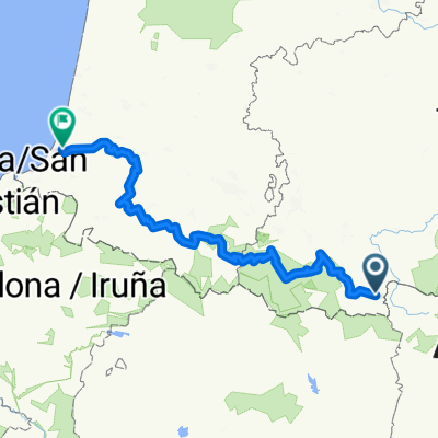
Trasy z Bagnères-de-Luchon
Jednodniowa wycieczka rowerowa od
Z Bagnères-de-Luchon do Saint-Lary-Soulan
Jednodniowa wycieczka rowerowa od
Z Bagnères-de-Luchon do Luz-Saint-Sauveur
Trasy do Bajonna
Rowerowa od
Z Biarritz do Bajonna