
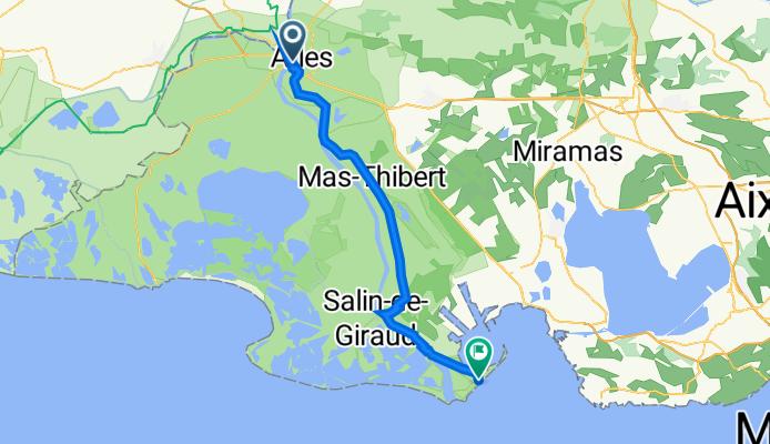
Jednodniowa wycieczka rowerowa z Arles do Port-Saint-Louis-du-Rhône
Dostosuj własną trasę na podstawie naszego szablonu lub zobacz, jak nasza społeczność najchętniej jeździ z Arles do Port-Saint-Louis-du-Rhône.
Szablon trasy
Z Arles do Port-Saint-Louis-du-Rhône

- 2 h 32 min
- Czas
- 46,9 km
- Dystans
- 23 m
- Przewyższenia
- 48 m
- Spadek
- 18,5 km/h
- Śr. Prędkość
- 24 m
- Maks. wysokość
This relaxed ride takes you from historic Arles, famous for its Roman monuments and Vincent van Gogh’s colorful memories, down to the wind-swept shores of Port-Saint-Louis-du-Rhône—gateway to the Camargue wetlands and the Mediterranean.
The route itself stretches just under 47 km, mostly on smooth asphalt and dedicated cycleways, meaning you'll have loads of space to just spin and enjoy the scenery. Don’t let the nearly pancake-flat profile fool you: the landscape changes dramatically, from Arles’ ancient streets to wide-open marshes, rice paddies, and the dreamy Rhône riverbanks. Expect a bit of gravel and rougher paths (about 10-20%), especially as you get closer to the coast, but it’s nothing a gravel or hybrid bike can’t handle.
Take time to enjoy the birds and wild horses if you’re lucky, and finish up in Port-Saint-Louis, a laidback port town best known for its seafood and wild beaches. Bring some snacks and plenty of water—the last stretch feels remote, but the peaceful vibe is worth every pedal stroke!
Wspólnota
Najlepsi użytkownicy w tym regionie


Od naszej społeczności
Najlepsze trasy rowerowe z Arles do Port-Saint-Louis-du-Rhône

Arles_Camargue
Trasa rowerowa w Arles, Prowansja-Alpy-Lazurowe Wybrzeże, Francja
- 50,1 km
- Dystans
- 8 m
- Przewyższenia
- 9 m
- Spadek

Arles - Salin de Giraud
Trasa rowerowa w Arles, Prowansja-Alpy-Lazurowe Wybrzeże, Francja
- 65,8 km
- Dystans
- 4 m
- Przewyższenia
- 12 m
- Spadek

Arles à Plage de Piémanson
Trasa rowerowa w Arles, Prowansja-Alpy-Lazurowe Wybrzeże, Francja
- 50,6 km
- Dystans
- 5 m
- Przewyższenia
- 10 m
- Spadek

JOUR 1
Trasa rowerowa w Arles, Prowansja-Alpy-Lazurowe Wybrzeże, Francja
- 36 km
- Dystans
- 0 m
- Przewyższenia
- 0 m
- Spadek

J-4 Arles Napoléon
Trasa rowerowa w Arles, Prowansja-Alpy-Lazurowe Wybrzeże, Francja
- 50 km
- Dystans
- 10 m
- Przewyższenia
- 30 m
- Spadek

20 Place Lamartine, Arles nach Route du Bac de Barcarin, Arles
Trasa rowerowa w Arles, Prowansja-Alpy-Lazurowe Wybrzeże, Francja
- 50,4 km
- Dystans
- 147 m
- Przewyższenia
- 151 m
- Spadek

Arles - Piémanson
Trasa rowerowa w Arles, Prowansja-Alpy-Lazurowe Wybrzeże, Francja
- 52,6 km
- Dystans
- 36 m
- Przewyższenia
- 44 m
- Spadek

25: ViaRhôna d'Arles à Port-St-Louis-du-Rhône
Trasa rowerowa w Arles, Prowansja-Alpy-Lazurowe Wybrzeże, Francja
- 51,6 km
- Dystans
- 3 m
- Przewyższenia
- 9 m
- Spadek

6. Tag
Trasa rowerowa w Arles, Prowansja-Alpy-Lazurowe Wybrzeże, Francja
- 34,5 km
- Dystans
- 8 m
- Przewyższenia
- 26 m
- Spadek

Arles / Plage Napoléon
Trasa rowerowa w Arles, Prowansja-Alpy-Lazurowe Wybrzeże, Francja
- 52,4 km
- Dystans
- 9 m
- Przewyższenia
- 12 m
- Spadek
Etappe 6
Trasa rowerowa w Arles, Prowansja-Alpy-Lazurowe Wybrzeże, Francja
- 69 km
- Dystans
- 52 m
- Przewyższenia
- 61 m
- Spadek

Camargues - Arles - Port Saint Louis du Rhônes
Trasa rowerowa w Arles, Prowansja-Alpy-Lazurowe Wybrzeże, Francja
- 53,1 km
- Dystans
- 16 m
- Przewyższenia
- 19 m
- Spadek
Odkryj więcej tras
 J-4 Arles Napoléon
- Dystans
- 50 km
- Przewyższenia
- 10 m
- Spadek
- 30 m
- Lokalizacja
- Arles, Prowansja-Alpy-Lazurowe Wybrzeże, Francja
 20 Place Lamartine, Arles nach Route du Bac de Barcarin, Arles
- Dystans
- 50,4 km
- Przewyższenia
- 147 m
- Spadek
- 151 m
- Lokalizacja
- Arles, Prowansja-Alpy-Lazurowe Wybrzeże, Francja
 Arles - Piémanson
- Dystans
- 52,6 km
- Przewyższenia
- 36 m
- Spadek
- 44 m
- Lokalizacja
- Arles, Prowansja-Alpy-Lazurowe Wybrzeże, Francja
 25: ViaRhôna d'Arles à Port-St-Louis-du-Rhône
- Dystans
- 51,6 km
- Przewyższenia
- 3 m
- Spadek
- 9 m
- Lokalizacja
- Arles, Prowansja-Alpy-Lazurowe Wybrzeże, Francja
 6. Tag
- Dystans
- 34,5 km
- Przewyższenia
- 8 m
- Spadek
- 26 m
- Lokalizacja
- Arles, Prowansja-Alpy-Lazurowe Wybrzeże, Francja
 Arles / Plage Napoléon
- Dystans
- 52,4 km
- Przewyższenia
- 9 m
- Spadek
- 12 m
- Lokalizacja
- Arles, Prowansja-Alpy-Lazurowe Wybrzeże, Francja
 Etappe 6
- Dystans
- 69 km
- Przewyższenia
- 52 m
- Spadek
- 61 m
- Lokalizacja
- Arles, Prowansja-Alpy-Lazurowe Wybrzeże, Francja
 Camargues - Arles - Port Saint Louis du Rhônes
- Dystans
- 53,1 km
- Przewyższenia
- 16 m
- Spadek
- 19 m
- Lokalizacja
- Arles, Prowansja-Alpy-Lazurowe Wybrzeże, Francja
Trasy z Arles
Jednodniowa wycieczka rowerowa od
Z Arles do Saintes-Maries-de-la-Mer