
Jednodniowa wycieczka rowerowa z Argelès-Gazost do Saint-Lary-Soulan
Dostosuj własną trasę na podstawie naszego szablonu lub zobacz, jak nasza społeczność najchętniej jeździ z Argelès-Gazost do Saint-Lary-Soulan.
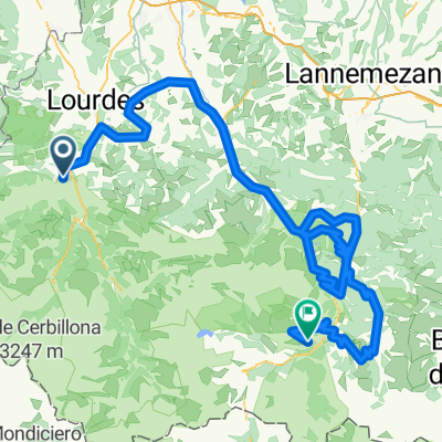
Szablon trasy
Z Argelès-Gazost do Saint-Lary-Soulan

- 7 h 56 min
- Czas
- 99 km
- Dystans
- 3119 m
- Przewyższenia
- 2839 m
- Spadek
- 12,5 km/h
- Śr. Prędkość
- 1602 m
- Maks. wysokość
Ready for a classic Pyrenean adventure? Kick things off in Argelès-Gazost, a welcoming spa town nestled at the foothills of the mountains, perfect for a last coffee before you hit the big climbs. From here, you’ll traverse nearly 100 km towards the famed Saint-Lary-Soulan, a charming ski resort that’s just as lively in summer with cyclists as it is with skiers in winter.
Brace yourself for some serious climbing—over 3,000 meters of ascent! This route threads together quiet country roads and scenic paths, letting you soak in epic mountain views without too much traffic. Expect a patchwork of road surfaces; while most is paved or asphalt, there are sections of gravel and unpaved tracks, so a sturdy bike is a good idea.
Along the way, you’ll experience classic Pyrenean scenery—lush valleys, twisting climbs, and possibly some iconic Tour de France territory. Saint-Lary-Soulan will be waiting at the end, the perfect place to refuel and chill out after a big day out in the mountains. Hydrate well, pace yourself, and enjoy the ride!
Wspólnota
Najlepsi użytkownicy w tym regionie


Od naszej społeczności
Najlepsze trasy rowerowe z Argelès-Gazost do Saint-Lary-Soulan

**14-S. Argelès-Gazost - Lac de Cap Long (136,5 Km)
Trasa rowerowa w Argelès-Gazost, Occitanie, Francja
- 136,3 km
- Dystans
- 5080 m
- Przewyższenia
- 3641 m
- Spadek

TOURMALET_2014_02
Trasa rowerowa w Argelès-Gazost, Occitanie, Francja
- 98,3 km
- Dystans
- 2715 m
- Przewyższenia
- 1995 m
- Spadek

Pyrénées J3
Trasa rowerowa w Argelès-Gazost, Occitanie, Francja
- 81,6 km
- Dystans
- 2297 m
- Przewyższenia
- 2062 m
- Spadek

Pyrenäen 14.08.2011 - Sonntag
Trasa rowerowa w Argelès-Gazost, Occitanie, Francja
- 114,8 km
- Dystans
- 3205 m
- Przewyższenia
- 2815 m
- Spadek

Traversee des Pyrenees - Day 3 - Argeles to Cadeac
Trasa rowerowa w Argelès-Gazost, Occitanie, Francja
- 81,5 km
- Dystans
- 2313 m
- Przewyższenia
- 2045 m
- Spadek

PIRENEI 3° TAPPA: ARGELES GAZOST - ST. LARY SOULAN
Trasa rowerowa w Argelès-Gazost, Occitanie, Francja
- 90,8 km
- Dystans
- 2359 m
- Przewyższenia
- 1993 m
- Spadek

Pyrenees Etappe 6
Trasa rowerowa w Argelès-Gazost, Occitanie, Francja
- 78,2 km
- Dystans
- 2249 m
- Przewyższenia
- 1995 m
- Spadek

P22_Argeles Gazost - St Lary Solaun Pla D'Adet
Trasa rowerowa w Argelès-Gazost, Occitanie, Francja
- 166 km
- Dystans
- 4319 m
- Przewyższenia
- 3182 m
- Spadek

TransPireneje D04
Trasa rowerowa w Argelès-Gazost, Occitanie, Francja
- 78,6 km
- Dystans
- 2194 m
- Przewyższenia
- 2135 m
- Spadek

PIRENEI 3° TAPPA: ARGELES GAZOST - ST. LARY SOULAN
Trasa rowerowa w Argelès-Gazost, Occitanie, Francja
- 90,6 km
- Dystans
- 2356 m
- Przewyższenia
- 1990 m
- Spadek

Pyreneeen dag 2 v2
Trasa rowerowa w Argelès-Gazost, Occitanie, Francja
- 89,3 km
- Dystans
- 2577 m
- Przewyższenia
- 2041 m
- Spadek

TDF Tag 13
Trasa rowerowa w Argelès-Gazost, Occitanie, Francja
- 73,9 km
- Dystans
- 2367 m
- Przewyższenia
- 2111 m
- Spadek
Odkryj więcej tras
 Traversee des Pyrenees - Day 3 - Argeles to Cadeac
- Dystans
- 81,5 km
- Przewyższenia
- 2313 m
- Spadek
- 2045 m
- Lokalizacja
- Argelès-Gazost, Occitanie, Francja
 PIRENEI 3° TAPPA: ARGELES GAZOST - ST. LARY SOULAN
- Dystans
- 90,8 km
- Przewyższenia
- 2359 m
- Spadek
- 1993 m
- Lokalizacja
- Argelès-Gazost, Occitanie, Francja
 Pyrenees Etappe 6
- Dystans
- 78,2 km
- Przewyższenia
- 2249 m
- Spadek
- 1995 m
- Lokalizacja
- Argelès-Gazost, Occitanie, Francja
 P22_Argeles Gazost - St Lary Solaun Pla D'Adet
- Dystans
- 166 km
- Przewyższenia
- 4319 m
- Spadek
- 3182 m
- Lokalizacja
- Argelès-Gazost, Occitanie, Francja
 TransPireneje D04
- Dystans
- 78,6 km
- Przewyższenia
- 2194 m
- Spadek
- 2135 m
- Lokalizacja
- Argelès-Gazost, Occitanie, Francja
 PIRENEI 3° TAPPA: ARGELES GAZOST - ST. LARY SOULAN
- Dystans
- 90,6 km
- Przewyższenia
- 2356 m
- Spadek
- 1990 m
- Lokalizacja
- Argelès-Gazost, Occitanie, Francja
 Pyreneeen dag 2 v2
- Dystans
- 89,3 km
- Przewyższenia
- 2577 m
- Spadek
- 2041 m
- Lokalizacja
- Argelès-Gazost, Occitanie, Francja
 TDF Tag 13
- Dystans
- 73,9 km
- Przewyższenia
- 2367 m
- Spadek
- 2111 m
- Lokalizacja
- Argelès-Gazost, Occitanie, Francja
Trasy z Argelès-Gazost
Jednodniowa wycieczka rowerowa od
Z Argelès-Gazost do Arette
Jednodniowa wycieczka rowerowa od
Z Argelès-Gazost do Laruns
Szybka przejażdżka rowerowa od
Z Argelès-Gazost do Pierrefitte-Nestalas
Trasy do Saint-Lary-Soulan
Jednodniowa wycieczka rowerowa od
Z Campan do Saint-Lary-Soulan
Jednodniowa wycieczka rowerowa od
Z Bagnères-de-Luchon do Saint-Lary-Soulan