
Jednodniowa wycieczka rowerowa z Argelès-Gazost do Luz-Saint-Sauveur
Dostosuj własną trasę na podstawie naszego szablonu lub zobacz, jak nasza społeczność najchętniej jeździ z Argelès-Gazost do Luz-Saint-Sauveur.
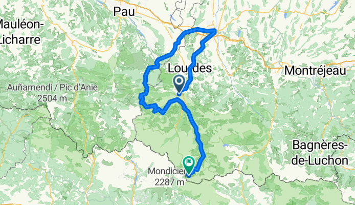
Szablon trasy
Z Argelès-Gazost do Luz-Saint-Sauveur

- 5 h 34 min
- Czas
- 47,9 km
- Dystans
- 3126 m
- Przewyższenia
- 2953 m
- Spadek
- 8,6 km/h
- Śr. Prędkość
- 1946 m
- Maks. wysokość
Argelès-Gazost → Luz-Saint-Sauveur Cycling Route
Get ready for an epic ride through the heart of the Pyrenees! This 48 km adventure starts in the charming spa town of Argelès-Gazost, famous for its thermal baths and beautiful Belle Époque architecture—perfect for a pre-ride stroll and coffee.
The route packs a serious punch, climbing over 3,000 meters (yep, your legs will feel it!) and topping out at nearly 2,000 meters elevation. You’ll cruise along a patchwork of surfaces, from smooth asphalt to gravel and natural ground. Paths and quiet tracks make up most of the journey, letting you soak in mountain views away from traffic. Don’t be surprised by the occasional technical bit; about half the way has an “off the beaten path” feel.
Finish in Luz-Saint-Sauveur, a lively mountain town and gateway to legendary climbs like the Col du Tourmalet. Grab a pastry, unwind, and swap stories—this route’s a bucket-list challenge for any cycling adventurer!
Wspólnota
Najlepsi użytkownicy w tym regionie


Od naszej społeczności
Najlepsze trasy rowerowe z Argelès-Gazost do Luz-Saint-Sauveur

Pirenaica11. Agos-Vidalos - Luz-Saint-Sauveur
Trasa rowerowa w Argelès-Gazost, Occitanie, Francja
- 121 km
- Dystans
- 3391 m
- Przewyższenia
- 3074 m
- Spadek

De Aucun a Sazos
Trasa rowerowa w Argelès-Gazost, Occitanie, Francja
- 51,2 km
- Dystans
- 1185 m
- Przewyższenia
- 1242 m
- Spadek

De Place de la République 4, Argelès-Gazost à Le Village 176, Gavarnie-Gèdre
Trasa rowerowa w Argelès-Gazost, Occitanie, Francja
- 39,4 km
- Dystans
- 2063 m
- Przewyższenia
- 1141 m
- Spadek

etapa 3
Trasa rowerowa w Argelès-Gazost, Occitanie, Francja
- 135,1 km
- Dystans
- 3805 m
- Przewyższenia
- 3584 m
- Spadek

Argeles - Gazost Cirque Troumouse
Trasa rowerowa w Argelès-Gazost, Occitanie, Francja
- 47,7 km
- Dystans
- 1719 m
- Przewyższenia
- 86 m
- Spadek

Tourmalet
Trasa rowerowa w Argelès-Gazost, Occitanie, Francja
- 29,7 km
- Dystans
- 1207 m
- Przewyższenia
- 166 m
- Spadek
P21_Argeles Gazost - Port de Boucharo
Trasa rowerowa w Argelès-Gazost, Occitanie, Francja
- 169,3 km
- Dystans
- 3538 m
- Przewyższenia
- 1795 m
- Spadek

Recovered Route
Trasa rowerowa w Argelès-Gazost, Occitanie, Francja
- 39,4 km
- Dystans
- 1407 m
- Przewyższenia
- 662 m
- Spadek

Col des Tentes depuis Agos Vidalos
Trasa rowerowa w Argelès-Gazost, Occitanie, Francja
- 52,9 km
- Dystans
- 1853 m
- Przewyższenia
- 50 m
- Spadek

Troumouse depuis Agos Vidalos
Trasa rowerowa w Argelès-Gazost, Occitanie, Francja
- 51,4 km
- Dystans
- 1736 m
- Przewyższenia
- 47 m
- Spadek

troumouse
Trasa rowerowa w Argelès-Gazost, Occitanie, Francja
- 51,1 km
- Dystans
- 1754 m
- Przewyższenia
- 66 m
- Spadek

Ra_P_S-F_d05.1
Trasa rowerowa w Argelès-Gazost, Occitanie, Francja
- 135,4 km
- Dystans
- 4335 m
- Przewyższenia
- 2700 m
- Spadek
Odkryj więcej tras
 Argeles - Gazost Cirque Troumouse
- Dystans
- 47,7 km
- Przewyższenia
- 1719 m
- Spadek
- 86 m
- Lokalizacja
- Argelès-Gazost, Occitanie, Francja
 Tourmalet
- Dystans
- 29,7 km
- Przewyższenia
- 1207 m
- Spadek
- 166 m
- Lokalizacja
- Argelès-Gazost, Occitanie, Francja
 P21_Argeles Gazost - Port de Boucharo
- Dystans
- 169,3 km
- Przewyższenia
- 3538 m
- Spadek
- 1795 m
- Lokalizacja
- Argelès-Gazost, Occitanie, Francja
 Recovered Route
- Dystans
- 39,4 km
- Przewyższenia
- 1407 m
- Spadek
- 662 m
- Lokalizacja
- Argelès-Gazost, Occitanie, Francja
 Col des Tentes depuis Agos Vidalos
- Dystans
- 52,9 km
- Przewyższenia
- 1853 m
- Spadek
- 50 m
- Lokalizacja
- Argelès-Gazost, Occitanie, Francja
 Troumouse depuis Agos Vidalos
- Dystans
- 51,4 km
- Przewyższenia
- 1736 m
- Spadek
- 47 m
- Lokalizacja
- Argelès-Gazost, Occitanie, Francja
 troumouse
- Dystans
- 51,1 km
- Przewyższenia
- 1754 m
- Spadek
- 66 m
- Lokalizacja
- Argelès-Gazost, Occitanie, Francja
 Ra_P_S-F_d05.1
- Dystans
- 135,4 km
- Przewyższenia
- 4335 m
- Spadek
- 2700 m
- Lokalizacja
- Argelès-Gazost, Occitanie, Francja
Trasy z Argelès-Gazost
Jednodniowa wycieczka rowerowa od
Z Argelès-Gazost do Cauterets
Jednodniowa wycieczka rowerowa od
Z Argelès-Gazost do Saint-Lary-Soulan
Szybka przejażdżka rowerowa od
Z Argelès-Gazost do Pierrefitte-Nestalas
Trasy do Luz-Saint-Sauveur
Jednodniowa wycieczka rowerowa od
Z Bagnères-de-Luchon do Luz-Saint-Sauveur
Jednodniowa wycieczka rowerowa od
Z Saint-Lary-Soulan do Luz-Saint-Sauveur