
Jednodniowa wycieczka rowerowa z Argelès-Gazost do Arette
Dostosuj własną trasę na podstawie naszego szablonu lub zobacz, jak nasza społeczność najchętniej jeździ z Argelès-Gazost do Arette.
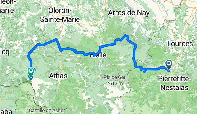
Szablon trasy
Z Argelès-Gazost do Arette

- 8 h 28 min
- Czas
- 126,1 km
- Dystans
- 2309 m
- Przewyższenia
- 2513 m
- Spadek
- 14,9 km/h
- Śr. Prędkość
- 563 m
- Maks. wysokość
This route takes you from the charming town of Argelès-Gazost, nestled at the foothills of the Pyrenees, all the way to Arette, on the edge of the Béarn region. Starting in Argelès-Gazost—famous for its thermal baths and as a gateway to classic Pyrenean climbs—you’ll be tackling about 126 km and over 2,300 meters of climbing, so it’s definitely one for the mountain goats!
You’ll spend most of the day cruising on quiet roads and taking in the stunning alpine scenery, with some stretches on paths and cycleways that offer a relaxing break from traffic. Expect a mix of surfaces, with mostly good asphalt, but be ready for a few gravelly patches—nothing too technical, just a touch of adventure!
Finishing in Arette, a picturesque village known for skiing in the winter and its proximity to the legendary Col de la Pierre Saint-Martin, you’ll have plenty of bragging rights. Whether you’re in it for the challenge or just the views, this route is a proper Pyrénéan adventure!
Wspólnota
Najlepsi użytkownicy w tym regionie


Od naszej społeczności
Najlepsze trasy rowerowe z Argelès-Gazost do Arette

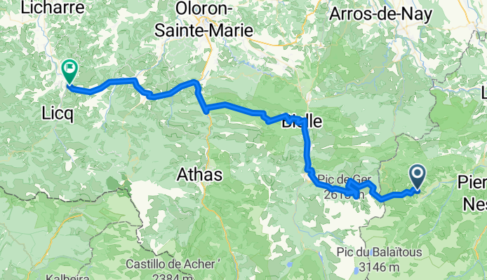
Argeles-Gazost - Montory
Trasa rowerowa w Argelès-Gazost, Occitanie, Francja
- 101,1 km
- Dystans
- 2115 m
- Przewyższenia
- 2295 m
- Spadek

18-J. Argeles-Gazost - La Pierre Saint Martin (141 Km)
Trasa rowerowa w Argelès-Gazost, Occitanie, Francja
- 141 km
- Dystans
- 6082 m
- Przewyższenia
- 4871 m
- Spadek

Argeles - Arette
Trasa rowerowa w Argelès-Gazost, Occitanie, Francja
- 90,1 km
- Dystans
- 2014 m
- Przewyższenia
- 2165 m
- Spadek

Argelès-Gazost > La Pierre Saint Martin
Trasa rowerowa w Argelès-Gazost, Occitanie, Francja
- 112,7 km
- Dystans
- 1805 m
- Przewyższenia
- 716 m
- Spadek

Dag 5 Meerdaagse 2014
Trasa rowerowa w Argelès-Gazost, Occitanie, Francja
- 124,8 km
- Dystans
- 2358 m
- Przewyższenia
- 2199 m
- Spadek

Coast to Coast 5
Trasa rowerowa w Argelès-Gazost, Occitanie, Francja
- 125,9 km
- Dystans
- 2320 m
- Przewyższenia
- 2164 m
- Spadek

Soulor 1474m - Aubisque 1709m - Marie Blanque 1035m
Trasa rowerowa w Argelès-Gazost, Occitanie, Francja
- 80,1 km
- Dystans
- 2488 m
- Przewyższenia
- 2589 m
- Spadek
Argeles to Pierre St Martin
Trasa rowerowa w Argelès-Gazost, Occitanie, Francja
- 118,6 km
- Dystans
- 3233 m
- Przewyższenia
- 2066 m
- Spadek

Soulor - Aubisque - Marie Blanque - Ichere
Trasa rowerowa w Argelès-Gazost, Occitanie, Francja
- 118,9 km
- Dystans
- 3474 m
- Przewyższenia
- 3651 m
- Spadek

Transpirenaica 07
Trasa rowerowa w Argelès-Gazost, Occitanie, Francja
- 76,1 km
- Dystans
- 1950 m
- Przewyższenia
- 2084 m
- Spadek
Argelès-Gazost - Arette
Trasa rowerowa w Argelès-Gazost, Occitanie, Francja
- 89 km
- Dystans
- 948 m
- Przewyższenia
- 1748 m
- Spadek

trans 2 con marie y casi larrau
Trasa rowerowa w Argelès-Gazost, Occitanie, Francja
- 138,1 km
- Dystans
- 3126 m
- Przewyższenia
- 3366 m
- Spadek
Odkryj więcej tras
 Dag 5 Meerdaagse 2014
- Dystans
- 124,8 km
- Przewyższenia
- 2358 m
- Spadek
- 2199 m
- Lokalizacja
- Argelès-Gazost, Occitanie, Francja
 Coast to Coast 5
- Dystans
- 125,9 km
- Przewyższenia
- 2320 m
- Spadek
- 2164 m
- Lokalizacja
- Argelès-Gazost, Occitanie, Francja
 Soulor 1474m - Aubisque 1709m - Marie Blanque 1035m
- Dystans
- 80,1 km
- Przewyższenia
- 2488 m
- Spadek
- 2589 m
- Lokalizacja
- Argelès-Gazost, Occitanie, Francja
 Argeles to Pierre St Martin
- Dystans
- 118,6 km
- Przewyższenia
- 3233 m
- Spadek
- 2066 m
- Lokalizacja
- Argelès-Gazost, Occitanie, Francja
 Soulor - Aubisque - Marie Blanque - Ichere
- Dystans
- 118,9 km
- Przewyższenia
- 3474 m
- Spadek
- 3651 m
- Lokalizacja
- Argelès-Gazost, Occitanie, Francja
 Transpirenaica 07
- Dystans
- 76,1 km
- Przewyższenia
- 1950 m
- Spadek
- 2084 m
- Lokalizacja
- Argelès-Gazost, Occitanie, Francja
 Argelès-Gazost - Arette
- Dystans
- 89 km
- Przewyższenia
- 948 m
- Spadek
- 1748 m
- Lokalizacja
- Argelès-Gazost, Occitanie, Francja
 trans 2 con marie y casi larrau
- Dystans
- 138,1 km
- Przewyższenia
- 3126 m
- Spadek
- 3366 m
- Lokalizacja
- Argelès-Gazost, Occitanie, Francja
Trasy z Argelès-Gazost
Jednodniowa wycieczka rowerowa od
Z Argelès-Gazost do Laruns
Jednodniowa wycieczka rowerowa od
Z Argelès-Gazost do Cauterets
Rowerowa od
Z Argelès-Gazost do Pierrefitte-Nestalas
Trasy do Arette
Jednodniowa wycieczka rowerowa od
Z Laruns do Arette