
Szablon trasy
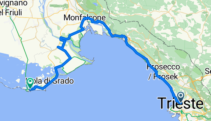
Z Triest do Grado
This ride takes you from the vibrant port city of Trieste to the lagoon town of Grado—a journey mixing coastal breezes, countryside calm, and a hint of adventure. Trieste, hugging Italy’s easternmost edge, feels both Italian and a touch Central European. You’ll pedal over about 80 kilometers, climbing a fair share (just under 1,000 meters of ascent), so expect a few rolling hills, especially early on as you leave Trieste’s dramatic karst ridges behind.
The route is pretty diverse: about 47% paved and another 42% on asphalt, but keep an eye out for gravel stretches (around 28%). The ride weaves between quiet country lanes, scenic tracks, and some dedicated cycleways—minimal time spent on busy roads, which is always a win.
Arriving in Grado, you’re greeted by golden beaches and the peaceful vibe of an island town known as the “Sunny Island.” It’s famous for its lagoon views and delicious seafood. Perfect for a post-ride gelato or a dip in the Adriatic!
Wspólnota
Najlepsi użytkownicy w tym regionie
Od naszej społeczności
Najlepsze trasy rowerowe z Triest do Grado
Cassacco - Grado
Trasa rowerowa w Triest, Friuli Venezia Giulia, Włochy
- 59,7 km
- Dystans
- 472 m
- Przewyższenia
- 486 m
- Spadek
2009.5-Friaultour, Triest-Grado
Trasa rowerowa w Triest, Friuli Venezia Giulia, Włochy
- 65,6 km
- Dystans
- 446 m
- Przewyższenia
- 458 m
- Spadek
pedalatina fisiologica a Grado
Trasa rowerowa w Triest, Friuli Venezia Giulia, Włochy
- 61,2 km
- Dystans
- 198 m
- Przewyższenia
- 202 m
- Spadek
Route to Riva Palace Hotel
Trasa rowerowa w Triest, Friuli Venezia Giulia, Włochy
- 58,6 km
- Dystans
- 469 m
- Przewyższenia
- 474 m
- Spadek
Tiest - Grado
Trasa rowerowa w Triest, Friuli Venezia Giulia, Włochy
- 62 km
- Dystans
- 337 m
- Przewyższenia
- 353 m
- Spadek
Trieste-Grado via San Giovanni al Natisone
Trasa rowerowa w Triest, Friuli Venezia Giulia, Włochy
- 109,3 km
- Dystans
- 314 m
- Przewyższenia
- 376 m
- Spadek
Parenzana 5. Etappe Triest, Karst, Hinterland, Grado
Trasa rowerowa w Triest, Friuli Venezia Giulia, Włochy
- 74,3 km
- Dystans
- 680 m
- Przewyższenia
- 701 m
- Spadek
Triest bis Grado
Trasa rowerowa w Triest, Friuli Venezia Giulia, Włochy
- 176 km
- Dystans
- 1679 m
- Przewyższenia
- 1678 m
- Spadek
Tiest - Grado
Trasa rowerowa w Triest, Friuli Venezia Giulia, Włochy
- 64 km
- Dystans
- 369 m
- Przewyższenia
- 388 m
- Spadek
TS - grado
Trasa rowerowa w Triest, Friuli Venezia Giulia, Włochy
- 90,6 km
- Dystans
- 83 m
- Przewyższenia
- 84 m
- Spadek
Trieste to Gradp
Trasa rowerowa w Triest, Friuli Venezia Giulia, Włochy
- 70,6 km
- Dystans
- 83 m
- Przewyższenia
- 97 m
- Spadek
Corso Italia 31–39, Triest nach Viale Argine dei Moreri 39–69, Grado
Trasa rowerowa w Triest, Friuli Venezia Giulia, Włochy
- 53,4 km
- Dystans
- 309 m
- Przewyższenia
- 329 m
- Spadek
Odkryj więcej tras
 Tiest - Grado
- Dystans
- 62 km
- Przewyższenia
- 337 m
- Spadek
- 353 m
- Lokalizacja
- Triest, Friuli Venezia Giulia, Włochy
 Trieste-Grado via San Giovanni al Natisone
- Dystans
- 109,3 km
- Przewyższenia
- 314 m
- Spadek
- 376 m
- Lokalizacja
- Triest, Friuli Venezia Giulia, Włochy
 Parenzana 5. Etappe Triest, Karst, Hinterland, Grado
- Dystans
- 74,3 km
- Przewyższenia
- 680 m
- Spadek
- 701 m
- Lokalizacja
- Triest, Friuli Venezia Giulia, Włochy
 Triest bis Grado
- Dystans
- 176 km
- Przewyższenia
- 1679 m
- Spadek
- 1678 m
- Lokalizacja
- Triest, Friuli Venezia Giulia, Włochy
 Tiest - Grado
- Dystans
- 64 km
- Przewyższenia
- 369 m
- Spadek
- 388 m
- Lokalizacja
- Triest, Friuli Venezia Giulia, Włochy
 TS - grado
- Dystans
- 90,6 km
- Przewyższenia
- 83 m
- Spadek
- 84 m
- Lokalizacja
- Triest, Friuli Venezia Giulia, Włochy
 Trieste to Gradp
- Dystans
- 70,6 km
- Przewyższenia
- 83 m
- Spadek
- 97 m
- Lokalizacja
- Triest, Friuli Venezia Giulia, Włochy
 Corso Italia 31–39, Triest nach Viale Argine dei Moreri 39–69, Grado
- Dystans
- 53,4 km
- Przewyższenia
- 309 m
- Spadek
- 329 m
- Lokalizacja
- Triest, Friuli Venezia Giulia, Włochy
Trasy z Triest
Bikepacking od
Z Triest do Pula
Jednodniowa wycieczka rowerowa od
Z Triest do Muggia
Jednodniowa wycieczka rowerowa od
Z Triest do Karojba
Rowerowa od
Z Triest do Domio
Rowerowa od
Z Triest do Villa Opicina
Trasy do Grado
Bikepacking od
Z Villach do Grado
Bikepacking od
Z Tarvisio do Grado
Jednodniowa wycieczka rowerowa od
Z Gemona do Grado
Jednodniowa wycieczka rowerowa od
Z Udine do Grado


