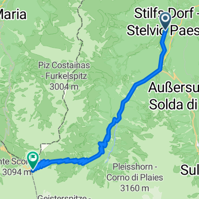

Jednodniowa wycieczka rowerowa z Stilfs do Sant'Antonio
Dostosuj własną trasę na podstawie naszego szablonu lub zobacz, jak nasza społeczność najchętniej jeździ z Stilfs do Sant'Antonio.
Szablon trasy
Z Stilfs do Sant'Antonio

- 10 h 59 min
- Czas
- 82,4 km
- Dystans
- 5007 m
- Przewyższenia
- 4976 m
- Spadek
- 7,5 km/h
- Śr. Prędkość
- 2625 m
- Maks. wysokość
Ready for a true mountain adventure? This route takes you from the picturesque village of Stilfs (also known as Stelvio), perched on the famous slopes of the Ortler Alps, all the way down to Sant’Antonio. Don’t let the 82 km distance fool you—this is a ride packed with serious climbing, with over 5,000 meters of ascent! You’ll work your way up to elevations above 2,600 meters, surrounded by incredible alpine scenery and likely some chilly air at the top.
The route is a real mixed bag surface-wise: part smooth asphalt, part gravel, and plenty of stretches where the path is less well defined—so prepare for some proper adventure riding. Over a third of your journey will be on tracks and paths, giving you a true taste of the remote, rugged side of South Tyrol and Lombardy.
Sant’Antonio is a small, peaceful village—the perfect finish after a big day in the saddle. Make sure you bring plenty of water, snacks, and layers; cell service could be unreliable in remote sections. This is one for seasoned riders looking for a challenge and epic mountain views!
Wspólnota
Najlepsi użytkownicy w tym regionie
Od naszej społeczności
Najlepsze trasy rowerowe z Stilfs do Sant'Antonio
5.TagAlpx2018
Trasa rowerowa w Stilfs, Południowy Tyrol, Włochy
- 47,8 km
- Dystans
- 1556 m
- Przewyższenia
- 1982 m
- Spadek
Route zu Hotel Vedig
Trasa rowerowa w Stilfs, Południowy Tyrol, Włochy
- 49,8 km
- Dystans
- 2959 m
- Przewyższenia
- 2653 m
- Spadek
Stelvio
Trasa rowerowa w Stilfs, Południowy Tyrol, Włochy
- 89,8 km
- Dystans
- 3349 m
- Przewyższenia
- 1926 m
- Spadek
06_Tag_Alpencross
Trasa rowerowa w Stilfs, Południowy Tyrol, Włochy
- 55,2 km
- Dystans
- 2185 m
- Przewyższenia
- 1959 m
- Spadek
3nap2018
Trasa rowerowa w Stilfs, Południowy Tyrol, Włochy
- 51,6 km
- Dystans
- 1950 m
- Przewyższenia
- 1501 m
- Spadek
Tag 5: Furkelhütte - Santa Cateria
Trasa rowerowa w Stilfs, Południowy Tyrol, Włochy
- 57 km
- Dystans
- 2127 m
- Przewyższenia
- 2547 m
- Spadek
Stelvio
Trasa rowerowa w Stilfs, Południowy Tyrol, Włochy
- 39,2 km
- Dystans
- 1891 m
- Przewyższenia
- 433 m
- Spadek
Passo della Stelvio
Trasa rowerowa w Stilfs, Południowy Tyrol, Włochy
- 18,6 km
- Dystans
- 1675 m
- Przewyższenia
- 48 m
- Spadek
solda -passo dello stelvio
Trasa rowerowa w Stilfs, Południowy Tyrol, Włochy
- 27,5 km
- Dystans
- 1497 m
- Przewyższenia
- 594 m
- Spadek
Prati allo Stelvio-Passo Stelvio
Trasa rowerowa w Stilfs, Południowy Tyrol, Włochy
- 20,4 km
- Dystans
- 1745 m
- Przewyższenia
- 94 m
- Spadek
Stilfserjoch
Trasa rowerowa w Stilfs, Południowy Tyrol, Włochy
- 20,9 km
- Dystans
- 1492 m
- Przewyższenia
- 45 m
- Spadek
Stilfserjoch
Trasa rowerowa w Stilfs, Południowy Tyrol, Włochy
- 17,8 km
- Dystans
- 1248 m
- Przewyższenia
- 103 m
- Spadek
Odkryj więcej tras
 3nap2018
- Dystans
- 51,6 km
- Przewyższenia
- 1950 m
- Spadek
- 1501 m
- Lokalizacja
- Stilfs, Południowy Tyrol, Włochy
 Tag 5: Furkelhütte - Santa Cateria
- Dystans
- 57 km
- Przewyższenia
- 2127 m
- Spadek
- 2547 m
- Lokalizacja
- Stilfs, Południowy Tyrol, Włochy
 Stelvio
- Dystans
- 39,2 km
- Przewyższenia
- 1891 m
- Spadek
- 433 m
- Lokalizacja
- Stilfs, Południowy Tyrol, Włochy
 Passo della Stelvio
- Dystans
- 18,6 km
- Przewyższenia
- 1675 m
- Spadek
- 48 m
- Lokalizacja
- Stilfs, Południowy Tyrol, Włochy
 solda -passo dello stelvio
- Dystans
- 27,5 km
- Przewyższenia
- 1497 m
- Spadek
- 594 m
- Lokalizacja
- Stilfs, Południowy Tyrol, Włochy
 Prati allo Stelvio-Passo Stelvio
- Dystans
- 20,4 km
- Przewyższenia
- 1745 m
- Spadek
- 94 m
- Lokalizacja
- Stilfs, Południowy Tyrol, Włochy
 Stilfserjoch
- Dystans
- 20,9 km
- Przewyższenia
- 1492 m
- Spadek
- 45 m
- Lokalizacja
- Stilfs, Południowy Tyrol, Włochy
 Stilfserjoch
- Dystans
- 17,8 km
- Przewyższenia
- 1248 m
- Spadek
- 103 m
- Lokalizacja
- Stilfs, Południowy Tyrol, Włochy
Trasy z Stilfs
Jednodniowa wycieczka rowerowa od
Z Stilfs do Bormio
Trasy do Sant'Antonio
Jednodniowa wycieczka rowerowa od
Z Prato allo Stelvio do Sant'Antonio
Rowerowa od
Z Bormio do Sant'Antonio


