
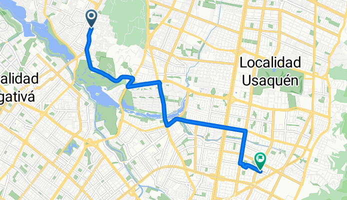
Jednodniowa wycieczka rowerowa z Cota do Barrio San Luis
Dostosuj własną trasę na podstawie naszego szablonu lub zobacz, jak nasza społeczność najchętniej jeździ z Cota do Barrio San Luis.
Szablon trasy
Z Cota do Barrio San Luis

- 2 h 25 min
- Czas
- 34,5 km
- Dystans
- 836 m
- Przewyższenia
- 335 m
- Spadek
- 14,3 km/h
- Śr. Prędkość
- 3059 m
- Maks. wysokość
Get ready for a rewarding ride from the charming town of Cota, nestled on the outskirts of Bogotá, all the way down to Barrio San Luis, a lively neighborhood in Bogotá’s southern area. This 34.5 km journey is not for the faint of heart—you’ll face a solid 835 meters of climbing, with most of the action happening early on as you leave Cota’s lush highlands behind.
The route offers a nice mix: just over half is on dedicated cycleways, perfect for enjoying the scenery and keeping things safe. About a quarter runs along busy roads—standard fare as you close in on the city—so stay alert here. Expect roughly half the paths to be smooth asphalt, but there are a few unpaved surprises along the way, so a sturdy bike is a plus.
As you roll into Barrio San Luis, you’ll enjoy a bustling local vibe; this district is close to green spaces like Parque Entrenubes and has direct access to Bogotá’s energetic city life. All in all, it’s a scenic, challenging ride—ideal for those wanting a taste of Cundinamarca’s green fields and Bogotá’s urban pulse in one go!
Wspólnota
Najlepsi użytkownicy w tym regionie


Od naszej społeczności
Najlepsze trasy rowerowe z Cota do Barrio San Luis
Calle 129D, Bogotá a Calle 103, Bogotá
Trasa rowerowa w Cota, Cundinamarca, Kolumbia
- 9,3 km
- Dystans
- 51 m
- Przewyższenia
- 56 m
- Spadek


De Bogotá a Carrera 94m 91-15, Bogotá
Trasa rowerowa w Cota, Cundinamarca, Kolumbia
- 56,6 km
- Dystans
- 417 m
- Przewyższenia
- 410 m
- Spadek

GF - 2020
Trasa rowerowa w Cota, Cundinamarca, Kolumbia
- 255,2 km
- Dystans
- 3477 m
- Przewyższenia
- 3446 m
- Spadek

Bogotá Patios
Trasa rowerowa w Cota, Cundinamarca, Kolumbia
- 22 km
- Dystans
- 513 m
- Przewyższenia
- 52 m
- Spadek

Avenida Calle 170 69-1–69-99, Bogotá a Calle 128C 86B-33, Bogotá
Trasa rowerowa w Cota, Cundinamarca, Kolumbia
- 6,9 km
- Dystans
- 112 m
- Przewyższenia
- 71 m
- Spadek

Calle 169B 67-50, Bogotá a Calle 128C 86B-30, Bogotá
Trasa rowerowa w Cota, Cundinamarca, Kolumbia
- 6,5 km
- Dystans
- 126 m
- Przewyższenia
- 89 m
- Spadek

Calle 209, Bogotá to Calle 105, Bogotá
Trasa rowerowa w Cota, Cundinamarca, Kolumbia
- 15,1 km
- Dystans
- 25 m
- Przewyższenia
- 24 m
- Spadek

universidad :c
Trasa rowerowa w Cota, Cundinamarca, Kolumbia
- 9,1 km
- Dystans
- 125 m
- Przewyższenia
- 97 m
- Spadek

De Calle 128 97-A13, Bogotá a Avenida Calle 116 18-96, Bogotá
Trasa rowerowa w Cota, Cundinamarca, Kolumbia
- 9,6 km
- Dystans
- 54 m
- Przewyższenia
- 72 m
- Spadek

De Calle 128 9759, Bogotá a Calle 118 22-90, Bogotá
Trasa rowerowa w Cota, Cundinamarca, Kolumbia
- 8,1 km
- Dystans
- 41 m
- Przewyższenia
- 66 m
- Spadek

Casa gratamira
Trasa rowerowa w Cota, Cundinamarca, Kolumbia
- 14,6 km
- Dystans
- 126 m
- Przewyższenia
- 222 m
- Spadek
De Calle 169B # 74A-02, Bogotá a Carrera 51a 127-75, Bogotá
Trasa rowerowa w Cota, Cundinamarca, Kolumbia
- 7,5 km
- Dystans
- 65 m
- Przewyższenia
- 70 m
- Spadek
Odkryj więcej tras
 Avenida Calle 170 69-1–69-99, Bogotá a Calle 128C 86B-33, Bogotá
- Dystans
- 6,9 km
- Przewyższenia
- 112 m
- Spadek
- 71 m
- Lokalizacja
- Cota, Cundinamarca, Kolumbia
 Calle 169B 67-50, Bogotá a Calle 128C 86B-30, Bogotá
- Dystans
- 6,5 km
- Przewyższenia
- 126 m
- Spadek
- 89 m
- Lokalizacja
- Cota, Cundinamarca, Kolumbia
 Calle 209, Bogotá to Calle 105, Bogotá
- Dystans
- 15,1 km
- Przewyższenia
- 25 m
- Spadek
- 24 m
- Lokalizacja
- Cota, Cundinamarca, Kolumbia
 universidad :c
- Dystans
- 9,1 km
- Przewyższenia
- 125 m
- Spadek
- 97 m
- Lokalizacja
- Cota, Cundinamarca, Kolumbia
 De Calle 128 97-A13, Bogotá a Avenida Calle 116 18-96, Bogotá
- Dystans
- 9,6 km
- Przewyższenia
- 54 m
- Spadek
- 72 m
- Lokalizacja
- Cota, Cundinamarca, Kolumbia
 De Calle 128 9759, Bogotá a Calle 118 22-90, Bogotá
- Dystans
- 8,1 km
- Przewyższenia
- 41 m
- Spadek
- 66 m
- Lokalizacja
- Cota, Cundinamarca, Kolumbia
 Casa gratamira
- Dystans
- 14,6 km
- Przewyższenia
- 126 m
- Spadek
- 222 m
- Lokalizacja
- Cota, Cundinamarca, Kolumbia
 De Calle 169B # 74A-02, Bogotá a Carrera 51a 127-75, Bogotá
- Dystans
- 7,5 km
- Przewyższenia
- 65 m
- Spadek
- 70 m
- Lokalizacja
- Cota, Cundinamarca, Kolumbia
Trasy z Cota
Jednodniowa wycieczka rowerowa od
Z Cota do Bogota
Jednodniowa wycieczka rowerowa od
Z Cota do Chía
Trasy do Barrio San Luis
Jednodniowa wycieczka rowerowa od
Z Funza do Barrio San Luis
Jednodniowa wycieczka rowerowa od
Z La Calera do Barrio San Luis
Rowerowa od
Z Bogota do Barrio San Luis