
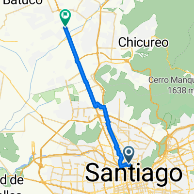
Jednodniowa wycieczka rowerowa z Santiago de Chile do Chicureo
Dostosuj własną trasę na podstawie naszego szablonu lub zobacz, jak nasza społeczność najchętniej jeździ z Santiago de Chile do Chicureo.
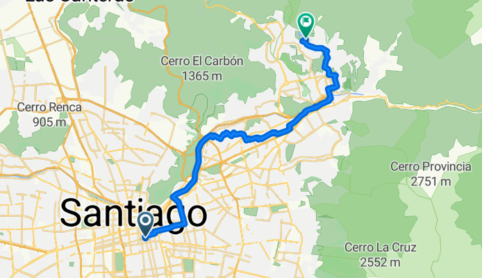
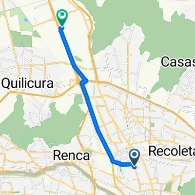
Szablon trasy
Z Santiago de Chile do Chicureo

- 2 h 31 min
- Czas
- 44,3 km
- Dystans
- 153 m
- Przewyższenia
- 147 m
- Spadek
- 17,6 km/h
- Śr. Prędkość
- 583 m
- Maks. wysokość
This route takes you from the heart of Santiago, Chile’s lively capital, all the way north to the quieter suburban enclave of Chicureo. It's a scenic ride of just over 44 km, so plan for a few hours in the saddle. Most of your journey rolls over smooth pavement—cycleways and quiet roads make up the bulk of the route, perfect for enjoying the views of the Andean foothills.
Santiago is known for its bustling vibe, colonial architecture, and the Andes backdrop. Once you leave the city, the pace slows down as you transition into the open spaces and vineyards around Chicureo. Expect gentle hills—there’s about 150 meters of climbing, but nothing too tough.
Chicureo is a fast-growing community known for its tranquil setting, golf courses, and country clubs. It’s a great spot to unwind after your ride, perhaps with a local treat at a café. Don’t forget to pack sunscreen and water, as stretches of the route can be exposed.
Overall, it’s an ideal adventure for those looking to escape the city’s buzz and enjoy the lesser-seen outskirts of Santiago.
Wspólnota
Najlepsi użytkownicy w tym regionie


Od naszej społeczności
Najlepsze trasy rowerowe z Santiago de Chile do Chicureo
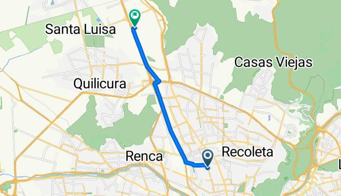
Carmen, Santiago a Los Sauzales, Lo Barnechea
Trasa rowerowa w Santiago de Chile, Region Metropolitalny, Chile
- 29 km
- Dystans
- 402 m
- Przewyższenia
- 34 m
- Spadek

Pie Andino
Trasa rowerowa w Santiago de Chile, Region Metropolitalny, Chile
- 24,6 km
- Dystans
- 401 m
- Przewyższenia
- 56 m
- Spadek

La Rinconada 4802, Huechuraba a Los Quillayes 6114, Huechuraba
Trasa rowerowa w Santiago de Chile, Region Metropolitalny, Chile
- 4,8 km
- Dystans
- 1726 m
- Przewyższenia
- 1642 m
- Spadek
Avenida Independencia 1425, Independencia a Pasaje Los Agustinos Sur 1630–1642, Huechuraba
Trasa rowerowa w Santiago de Chile, Region Metropolitalny, Chile
- 9 km
- Dystans
- 25 m
- Przewyższenia
- 68 m
- Spadek

Mapocho Expreso, Santiago a Avenida La Dehesa 3250, Lo Barnechea
Trasa rowerowa w Santiago de Chile, Region Metropolitalny, Chile
- 19,1 km
- Dystans
- 302 m
- Przewyższenia
- 15 m
- Spadek

República 243–291, Santiago a Calle Altos del Carmen 45–1431, Huechuraba
Trasa rowerowa w Santiago de Chile, Region Metropolitalny, Chile
- 13,5 km
- Dystans
- 17 m
- Przewyższenia
- 49 m
- Spadek

Clásica San Cristóbal
Trasa rowerowa w Santiago de Chile, Region Metropolitalny, Chile
- 43,3 km
- Dystans
- 784 m
- Przewyższenia
- 745 m
- Spadek
Ruta Casa Pega
Trasa rowerowa w Santiago de Chile, Region Metropolitalny, Chile
- 23,8 km
- Dystans
- 22 m
- Przewyższenia
- 64 m
- Spadek

cerro Manquehue
Trasa rowerowa w Santiago de Chile, Region Metropolitalny, Chile
- 12,7 km
- Dystans
- 1016 m
- Przewyższenia
- 19 m
- Spadek

Travesía del manquehue
Trasa rowerowa w Santiago de Chile, Region Metropolitalny, Chile
- 18,8 km
- Dystans
- 1611 m
- Przewyższenia
- 1176 m
- Spadek
independiencia hacia Komatsu
Trasa rowerowa w Santiago de Chile, Region Metropolitalny, Chile
- 10,4 km
- Dystans
- 7 m
- Przewyższenia
- 64 m
- Spadek

Estacionamiento Ciudad Empresarial, Huechuraba a Los Gomeros 604–632, Huechuraba
Trasa rowerowa w Santiago de Chile, Region Metropolitalny, Chile
- 4,7 km
- Dystans
- 60 m
- Przewyższenia
- 6 m
- Spadek
Odkryj więcej tras
 Mapocho Expreso, Santiago a Avenida La Dehesa 3250, Lo Barnechea
- Dystans
- 19,1 km
- Przewyższenia
- 302 m
- Spadek
- 15 m
- Lokalizacja
- Santiago de Chile, Region Metropolitalny, Chile
 República 243–291, Santiago a Calle Altos del Carmen 45–1431, Huechuraba
- Dystans
- 13,5 km
- Przewyższenia
- 17 m
- Spadek
- 49 m
- Lokalizacja
- Santiago de Chile, Region Metropolitalny, Chile
 Clásica San Cristóbal
- Dystans
- 43,3 km
- Przewyższenia
- 784 m
- Spadek
- 745 m
- Lokalizacja
- Santiago de Chile, Region Metropolitalny, Chile
 Ruta Casa Pega
- Dystans
- 23,8 km
- Przewyższenia
- 22 m
- Spadek
- 64 m
- Lokalizacja
- Santiago de Chile, Region Metropolitalny, Chile
 cerro Manquehue
- Dystans
- 12,7 km
- Przewyższenia
- 1016 m
- Spadek
- 19 m
- Lokalizacja
- Santiago de Chile, Region Metropolitalny, Chile
 Travesía del manquehue
- Dystans
- 18,8 km
- Przewyższenia
- 1611 m
- Spadek
- 1176 m
- Lokalizacja
- Santiago de Chile, Region Metropolitalny, Chile
 independiencia hacia Komatsu
- Dystans
- 10,4 km
- Przewyższenia
- 7 m
- Spadek
- 64 m
- Lokalizacja
- Santiago de Chile, Region Metropolitalny, Chile
 Estacionamiento Ciudad Empresarial, Huechuraba a Los Gomeros 604–632, Huechuraba
- Dystans
- 4,7 km
- Przewyższenia
- 60 m
- Spadek
- 6 m
- Lokalizacja
- Santiago de Chile, Region Metropolitalny, Chile
Trasy z Santiago de Chile
Jednodniowa wycieczka rowerowa od
Z Santiago de Chile do Puente Alto
Jednodniowa wycieczka rowerowa od
Z Santiago de Chile do San Bernardo
Rowerowa od
Z Santiago de Chile do Lo Prado
Rowerowa od
Z Santiago de Chile do Villa Presidente Frei
Trasy do Chicureo
Jednodniowa wycieczka rowerowa od
Z Villa Presidente Frei do Chicureo
Jednodniowa wycieczka rowerowa od
Z Lo Prado do Chicureo