
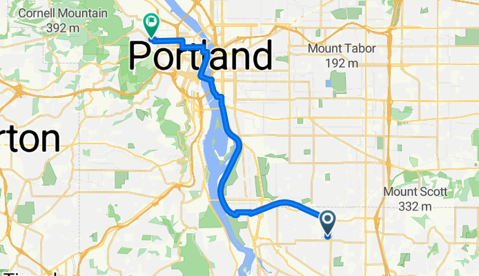
Szablon trasy
Z Milwaukie do Portland

- 42 min
- Czas
- 12 km
- Dystans
- 107 m
- Przewyższenia
- 109 m
- Spadek
- 17,1 km/h
- Śr. Prędkość
- 36 m
- Maks. wysokość
This relaxed cycling route takes you from the charming riverside city of Milwaukie up to the vibrant heart of Portland. Covering just over 12 km, the ride mostly cruises along dedicated cycleways and smooth paved paths, making it a great option for a stress-free commute or a leisurely exploration.
Starting in Milwaukie—a friendly spot known for its riverfront park and the historic Milwaukie Farmers Market—you’ll pedal northward, gently gaining and losing around 100 meters of elevation. The route keeps things easy on your legs, rarely climbing above 36 meters max!
You’ll roll through a mix of quiet residential streets and scenic greenways, with most of your journey on either cycle paths or well-maintained asphalt surfaces. Expect only brief stretches on roads and a taste of Portland’s urban buzz as you near your destination.
End your ride in downtown Portland, famous for its bridges, coffee shops, arts scene, and food carts. Whether you’re a local or visiting, this route offers a fun and laid-back way to connect Milwaukie and Portland—perfect for everyday riders and weekend explorers alike.
Wspólnota
Najlepsi użytkownicy w tym regionie


Od naszej społeczności
Najlepsze trasy rowerowe z Milwaukie do Portland

Willamette Greenway to Tillicum loop
Trasa rowerowa w Milwaukie, Oregon, USA
- 16,6 km
- Dystans
- 118 m
- Przewyższenia
- 131 m
- Spadek


Southeast 28th Avenue 4904, Portland to Southeast 7th Avenue 302, Portland
Trasa rowerowa w Milwaukie, Oregon, USA
- 7,7 km
- Dystans
- 32 m
- Przewyższenia
- 19 m
- Spadek

Springwater Corridor Trail
Trasa rowerowa w Milwaukie, Oregon, USA
- 8,4 km
- Dystans
- 31 m
- Przewyższenia
- 57 m
- Spadek
S Macadam Ave, Portland to SE Rhone St, Portland
Trasa rowerowa w Milwaukie, Oregon, USA
- 5,4 km
- Dystans
- 54 m
- Przewyższenia
- 86 m
- Spadek


Southeast Spokane Street 316, Portland to South Abernethy Street 698, Portland
Trasa rowerowa w Milwaukie, Oregon, USA
- 12,9 km
- Dystans
- 165 m
- Przewyższenia
- 137 m
- Spadek

Southeast Colt Drive 2813-2847, Portland to Southeast 8th Avenue 315, Portland
Trasa rowerowa w Milwaukie, Oregon, USA
- 5,3 km
- Dystans
- 19 m
- Przewyższenia
- 30 m
- Spadek

Southeast 28th Avenue 4904, Portland to Southeast 8th Avenue 303, Portland
Trasa rowerowa w Milwaukie, Oregon, USA
- 5,7 km
- Dystans
- 32 m
- Przewyższenia
- 21 m
- Spadek

Odkryj więcej tras
 Springwater Corridor Trail
- Dystans
- 8,4 km
- Przewyższenia
- 31 m
- Spadek
- 57 m
- Lokalizacja
- Milwaukie, Oregon, USA
 S Macadam Ave, Portland to SE Rhone St, Portland
- Dystans
- 5,4 km
- Przewyższenia
- 54 m
- Spadek
- 86 m
- Lokalizacja
- Milwaukie, Oregon, USA
 Sellwood Park
- Dystans
- 9,9 km
- Przewyższenia
- 97 m
- Spadek
- 58 m
- Lokalizacja
- Milwaukie, Oregon, USA
 Southeast Spokane Street 316, Portland to South Abernethy Street 698, Portland
- Dystans
- 12,9 km
- Przewyższenia
- 165 m
- Spadek
- 137 m
- Lokalizacja
- Milwaukie, Oregon, USA
 Southeast Colt Drive 2813-2847, Portland to Southeast 8th Avenue 315, Portland
- Dystans
- 5,3 km
- Przewyższenia
- 19 m
- Spadek
- 30 m
- Lokalizacja
- Milwaukie, Oregon, USA
 Southeast 28th Avenue 4904, Portland to Southeast 8th Avenue 303, Portland
- Dystans
- 5,7 km
- Przewyższenia
- 32 m
- Spadek
- 21 m
- Lokalizacja
- Milwaukie, Oregon, USA
 Route in Portland
- Dystans
- 17,7 km
- Przewyższenia
- 185 m
- Spadek
- 172 m
- Lokalizacja
- Milwaukie, Oregon, USA
 2/2/22 - B
- Dystans
- 13,1 km
- Przewyższenia
- 134 m
- Spadek
- 80 m
- Lokalizacja
- Milwaukie, Oregon, USA
Trasy do Portland
Jednodniowa wycieczka rowerowa od
Z Vancouver do Portland
Szybka przejażdżka rowerowa od
Z Lents do Portland