
Szybka przejażdżka rowerowa z North Vancouver do West End
Dostosuj własną trasę na podstawie naszego szablonu lub zobacz, jak nasza społeczność najchętniej jeździ z North Vancouver do West End.
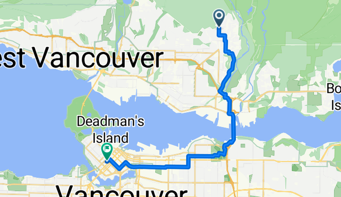
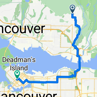
Szablon trasy
Z North Vancouver do West End

- 49 min
- Czas
- 13,5 km
- Dystans
- 154 m
- Przewyższenia
- 191 m
- Spadek
- 16,4 km/h
- Śr. Prędkość
- 86 m
- Maks. wysokość
Ready for a ride that crosses city vibes, seaside views, and a bit of gentle hillwork? This cycling route starts off in scenic North Vancouver, a community known for its mountains, forests, and easy access to the outdoors. From there, you’ll head south, cruising over mostly paved surfaces—lots of nice, smooth cycleways—making for an enjoyable trip, with only a sprinkle of gravel to keep things interesting.
You’ll climb just over 150 meters (and descend a bit more), but nothing too intense—max elevation is under 90 meters—which means you can focus more on the scenery than on your quads. The route lands you right in Vancouver’s West End, a lively neighborhood famous for its leafy streets, vibrant culture, and proximity to the beaches at English Bay and the trails in Stanley Park.
Expect mostly dedicated cycleways, quiet roads, and lots to see along the way. Whether you finish with a stroll on the seawall or a coffee in the West End, this route is a perfect city-to-shoreline ride.
Wspólnota
Najlepsi użytkownicy w tym regionie


Od naszej społeczności
Najlepsze trasy rowerowe z North Vancouver do West End

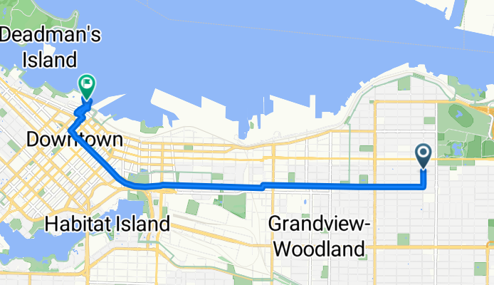
August 22, 2017
Trasa rowerowa w North Vancouver, Kolumbia Brytyjska, Kanada
- 30,9 km
- Dystans
- 171 m
- Przewyższenia
- 354 m
- Spadek

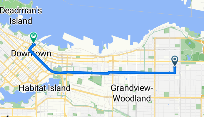
Dr. Huang to home
Trasa rowerowa w North Vancouver, Kolumbia Brytyjska, Kanada
- 12,9 km
- Dystans
- 156 m
- Przewyższenia
- 198 m
- Spadek

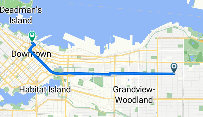
Lynn Canyon (3/3)
Trasa rowerowa w North Vancouver, Kolumbia Brytyjska, Kanada
- 24,7 km
- Dystans
- 193 m
- Przewyższenia
- 326 m
- Spadek

Lake Seymore
Trasa rowerowa w North Vancouver, Kolumbia Brytyjska, Kanada
- 54 km
- Dystans
- 507 m
- Przewyższenia
- 480 m
- Spadek

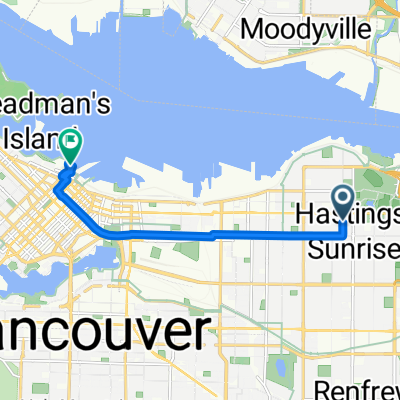
Brief ride through Vancouver
Trasa rowerowa w North Vancouver, Kolumbia Brytyjska, Kanada
- 9,9 km
- Dystans
- 104 m
- Przewyższenia
- 186 m
- Spadek

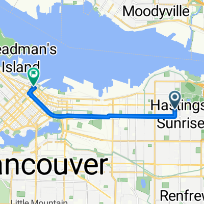
Daily Route to North Vancouver
Trasa rowerowa w North Vancouver, Kolumbia Brytyjska, Kanada
- 7,6 km
- Dystans
- 20 m
- Przewyższenia
- 92 m
- Spadek

Cycling
Trasa rowerowa w North Vancouver, Kolumbia Brytyjska, Kanada
- 61,7 km
- Dystans
- 537 m
- Przewyższenia
- 544 m
- Spadek
Evelyn St, North Vancouver to Hornby St, Vancouver
Trasa rowerowa w North Vancouver, Kolumbia Brytyjska, Kanada
- 17,9 km
- Dystans
- 166 m
- Przewyższenia
- 348 m
- Spadek

Tour um Vancouver 1
Trasa rowerowa w North Vancouver, Kolumbia Brytyjska, Kanada
- 62,3 km
- Dystans
- 901 m
- Przewyższenia
- 886 m
- Spadek
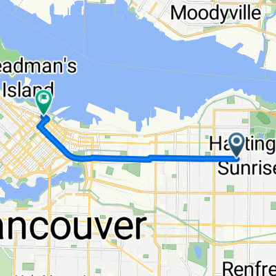
Kaslo Street to Burrard Street
Trasa rowerowa w North Vancouver, Kolumbia Brytyjska, Kanada
- 8,5 km
- Dystans
- 205 m
- Przewyższenia
- 189 m
- Spadek
Kaslo Street to Burrard Street
Trasa rowerowa w North Vancouver, Kolumbia Brytyjska, Kanada
- 6,8 km
- Dystans
- 76 m
- Przewyższenia
- 83 m
- Spadek
Kaslo Street to Burrard Street
Trasa rowerowa w North Vancouver, Kolumbia Brytyjska, Kanada
- 6,5 km
- Dystans
- 60 m
- Przewyższenia
- 73 m
- Spadek
Odkryj więcej tras
 Brief ride through Vancouver
- Dystans
- 9,9 km
- Przewyższenia
- 104 m
- Spadek
- 186 m
- Lokalizacja
- North Vancouver, Kolumbia Brytyjska, Kanada
 Daily Route to North Vancouver
- Dystans
- 7,6 km
- Przewyższenia
- 20 m
- Spadek
- 92 m
- Lokalizacja
- North Vancouver, Kolumbia Brytyjska, Kanada
 Cycling
- Dystans
- 61,7 km
- Przewyższenia
- 537 m
- Spadek
- 544 m
- Lokalizacja
- North Vancouver, Kolumbia Brytyjska, Kanada
 Evelyn St, North Vancouver to Hornby St, Vancouver
- Dystans
- 17,9 km
- Przewyższenia
- 166 m
- Spadek
- 348 m
- Lokalizacja
- North Vancouver, Kolumbia Brytyjska, Kanada
 Tour um Vancouver 1
- Dystans
- 62,3 km
- Przewyższenia
- 901 m
- Spadek
- 886 m
- Lokalizacja
- North Vancouver, Kolumbia Brytyjska, Kanada
 Kaslo Street to Burrard Street
- Dystans
- 8,5 km
- Przewyższenia
- 205 m
- Spadek
- 189 m
- Lokalizacja
- North Vancouver, Kolumbia Brytyjska, Kanada
 Kaslo Street to Burrard Street
- Dystans
- 6,8 km
- Przewyższenia
- 76 m
- Spadek
- 83 m
- Lokalizacja
- North Vancouver, Kolumbia Brytyjska, Kanada
 Kaslo Street to Burrard Street
- Dystans
- 6,5 km
- Przewyższenia
- 60 m
- Spadek
- 73 m
- Lokalizacja
- North Vancouver, Kolumbia Brytyjska, Kanada
Trasy z North Vancouver
Jednodniowa wycieczka rowerowa od
Z North Vancouver do West Vancouver
Szybka przejażdżka rowerowa od
Z North Vancouver do Vancouver
Szybka przejażdżka rowerowa od
Z North Vancouver do Burnaby
Trasy do West End
Jednodniowa wycieczka rowerowa od
Z New Westminster do West End
Jednodniowa wycieczka rowerowa od
Z Port Moody do West End
Szybka przejażdżka rowerowa od
Z Burnaby do West End
Szybka przejażdżka rowerowa od
Z Richmond do West End