
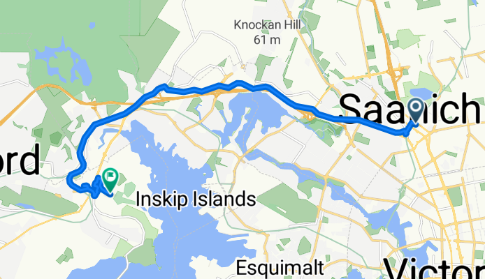
Szablon trasy
Z Victoria do Colwood

- 1 h 13 min
- Czas
- 18,8 km
- Dystans
- 221 m
- Przewyższenia
- 146 m
- Spadek
- 15,5 km/h
- Śr. Prędkość
- 92 m
- Maks. wysokość
This cycling route is a lovely ride from downtown Victoria out to Colwood, covering just under 19 km of mostly smooth terrain. Starting in the heart of Victoria, you’ll roll out past the Inner Harbour—don’t be surprised if you spot a few seaplanes taking off! The route is a great blend of traffic-free cycleways (almost 80%), which makes for a relaxed and enjoyable journey, with only short stretches on quiet or local roads.
Expect some gentle ups and downs, with around 220 meters of total climbing as you gradually make your way west. The scenery shifts from the urban charms of Victoria through leafy suburbs and scenic parks, so you’ll never get bored. Colwood, your destination, is historically rich—it's home to Fort Rodd Hill and the iconic Fisgard Lighthouse, where you can end your ride with some history and gorgeous ocean views. Almost the entire way is paved, so it’s a solid choice for all kinds of bikes. Bring a snack, soak in the sights, and enjoy a pleasant coastal ride!
Wspólnota
Najlepsi użytkownicy w tym regionie


Od naszej społeczności
Najlepsze trasy rowerowe z Victoria do Colwood

Sunday
Trasa rowerowa w Victoria, Kolumbia Brytyjska, Kanada
- 13,4 km
- Dystans
- 162 m
- Przewyższenia
- 107 m
- Spadek

Victoria to CanWest Mall via E & N and GG Trails
Trasa rowerowa w Victoria, Kolumbia Brytyjska, Kanada
- 35,5 km
- Dystans
- 282 m
- Przewyższenia
- 268 m
- Spadek

Royal Roads from Obed Street
Trasa rowerowa w Victoria, Kolumbia Brytyjska, Kanada
- 10,5 km
- Dystans
- 135 m
- Przewyższenia
- 124 m
- Spadek

Shop to Gravingdock 11
Trasa rowerowa w Victoria, Kolumbia Brytyjska, Kanada
- 5,1 km
- Dystans
- 46 m
- Przewyższenia
- 50 m
- Spadek

Uptown Bridge to Tim Hortons Colwood
Trasa rowerowa w Victoria, Kolumbia Brytyjska, Kanada
- 9,2 km
- Dystans
- 83 m
- Przewyższenia
- 57 m
- Spadek

Esquimalt at Sturdee to Ocean Boulevard 3344, Victoria
Trasa rowerowa w Victoria, Kolumbia Brytyjska, Kanada
- 14,1 km
- Dystans
- 112 m
- Przewyższenia
- 116 m
- Spadek

Test route
Trasa rowerowa w Victoria, Kolumbia Brytyjska, Kanada
- 24,3 km
- Dystans
- 130 m
- Przewyższenia
- 132 m
- Spadek

east sooke
Trasa rowerowa w Victoria, Kolumbia Brytyjska, Kanada
- 68,7 km
- Dystans
- 739 m
- Przewyższenia
- 698 m
- Spadek

Victoria Coast to Hatley
Trasa rowerowa w Victoria, Kolumbia Brytyjska, Kanada
- 49,2 km
- Dystans
- 555 m
- Przewyższenia
- 550 m
- Spadek

3110 Douglas St, Victoria to 2244 Sooke Rd, Colwood
Trasa rowerowa w Victoria, Kolumbia Brytyjska, Kanada
- 14,6 km
- Dystans
- 169 m
- Przewyższenia
- 103 m
- Spadek
Blanshard St, Saanich to Juan De Fuca Recreation Centre and Golf, Colwood
Trasa rowerowa w Victoria, Kolumbia Brytyjska, Kanada
- 11,6 km
- Dystans
- 103 m
- Przewyższenia
- 99 m
- Spadek

1635 Cook St, Victoria to 1501 Admirals Rd, View Royal
Trasa rowerowa w Victoria, Kolumbia Brytyjska, Kanada
- 9,9 km
- Dystans
- 262 m
- Przewyższenia
- 278 m
- Spadek
Odkryj więcej tras
 Uptown Bridge to Tim Hortons Colwood
- Dystans
- 9,2 km
- Przewyższenia
- 83 m
- Spadek
- 57 m
- Lokalizacja
- Victoria, Kolumbia Brytyjska, Kanada
 Esquimalt at Sturdee to Ocean Boulevard 3344, Victoria
- Dystans
- 14,1 km
- Przewyższenia
- 112 m
- Spadek
- 116 m
- Lokalizacja
- Victoria, Kolumbia Brytyjska, Kanada
 Test route
- Dystans
- 24,3 km
- Przewyższenia
- 130 m
- Spadek
- 132 m
- Lokalizacja
- Victoria, Kolumbia Brytyjska, Kanada
 east sooke
- Dystans
- 68,7 km
- Przewyższenia
- 739 m
- Spadek
- 698 m
- Lokalizacja
- Victoria, Kolumbia Brytyjska, Kanada
 Victoria Coast to Hatley
- Dystans
- 49,2 km
- Przewyższenia
- 555 m
- Spadek
- 550 m
- Lokalizacja
- Victoria, Kolumbia Brytyjska, Kanada
 3110 Douglas St, Victoria to 2244 Sooke Rd, Colwood
- Dystans
- 14,6 km
- Przewyższenia
- 169 m
- Spadek
- 103 m
- Lokalizacja
- Victoria, Kolumbia Brytyjska, Kanada
 Blanshard St, Saanich to Juan De Fuca Recreation Centre and Golf, Colwood
- Dystans
- 11,6 km
- Przewyższenia
- 103 m
- Spadek
- 99 m
- Lokalizacja
- Victoria, Kolumbia Brytyjska, Kanada
 1635 Cook St, Victoria to 1501 Admirals Rd, View Royal
- Dystans
- 9,9 km
- Przewyższenia
- 262 m
- Spadek
- 278 m
- Lokalizacja
- Victoria, Kolumbia Brytyjska, Kanada
Trasy z Victoria
Jednodniowa wycieczka rowerowa od
Z Victoria do North Saanich
Szybka przejażdżka rowerowa od
Z Victoria do Oak Bay
Szybka przejażdżka rowerowa od
Z Victoria do Langford