
Jednodniowa wycieczka rowerowa z Rucăr do Dâmbovicioara
Dostosuj własną trasę na podstawie naszego szablonu lub zobacz, jak nasza społeczność najchętniej jeździ z Rucăr do Dâmbovicioara.
Szablon trasy
Z Rucăr do Dâmbovicioara

- 2 h 25 min
- Czas
- 29,3 km
- Dystans
- 1365 m
- Przewyższenia
- 1052 m
- Spadek
- 12,1 km/h
- Śr. Prędkość
- 1253 m
- Maks. wysokość
This scenic cycling route takes you from the picturesque village of Rucăr to the mountain hamlet of Dâmbovicioara, with about 29 km of varied surfaces beneath your wheels. Kicking off in Rucăr—a gateway to Romania’s beautiful Piatra Craiului mountains—you’ll soon leave paved roads for winding gravel tracks and unpaved paths (expect a solid half of your ride off the tarmac).
The route is a bit of a rollercoaster, climbing more than 1,300 meters, so bring your climbing legs! The landscape makes all the effort worthwhile though: you’ll ride between forested hillsides and through spectacular valleys, with a couple of busy road sections but mostly tranquil, rural vibes.
Your destination, Dâmbovicioara, is famous for its dramatic gorge and the popular Dâmbovicioara Cave—well worth a post-ride wander. This is a route for adventure lovers craving classic Carpathian countryside, historical villages, and a bit of a challenge. Don’t forget your camera, and maybe some snacks—this is one for the bucket list!
Wspólnota
Najlepsi użytkownicy w tym regionie


Od naszej społeczności
Najlepsze trasy rowerowe z Rucăr do Dâmbovicioara

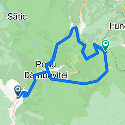
Podu Dâmboviței - Dâmbovicioara
Trasa rowerowa w Rucăr, Okręg Ardżesz, Rumunia
- 18,3 km
- Dystans
- 706 m
- Przewyższenia
- 552 m
- Spadek

Rucar-Satic
Trasa rowerowa w Rucăr, Okręg Ardżesz, Rumunia
- 18,7 km
- Dystans
- 432 m
- Przewyższenia
- 324 m
- Spadek


Strada Gura Dâmbovicioarei 252, Podu Dâmboviței to DJ730
Trasa rowerowa w Rucăr, Okręg Ardżesz, Rumunia
- 23,6 km
- Dystans
- 829 m
- Przewyższenia
- 720 m
- Spadek

Dambovicioara – Podu Dambovitei – Valea Cheii – Fundatica – Fundata – Sirnea – Ciocanu – Dambovicioara
Trasa rowerowa w Rucăr, Okręg Ardżesz, Rumunia
- 12,1 km
- Dystans
- 536 m
- Przewyższenia
- 136 m
- Spadek

ocolirea dealului Sasului
Trasa rowerowa w Rucăr, Okręg Ardżesz, Rumunia
- 65,5 km
- Dystans
- 1688 m
- Przewyższenia
- 1372 m
- Spadek

podul dambovicioarei - pestera uluce
Trasa rowerowa w Rucăr, Okręg Ardżesz, Rumunia
- 6 km
- Dystans
- 314 m
- Przewyższenia
- 86 m
- Spadek

Piatra Craiului Vest
Trasa rowerowa w Rucăr, Okręg Ardżesz, Rumunia
- 31,8 km
- Dystans
- 658 m
- Przewyższenia
- 313 m
- Spadek

Rucar Dambovicioara Brusturet
Trasa rowerowa w Rucăr, Okręg Ardżesz, Rumunia
- 14,8 km
- Dystans
- 713 m
- Przewyższenia
- 396 m
- Spadek

Satic -Dambovicioara-Ciocanu-Sirnea-Magura Fundata
Trasa rowerowa w Rucăr, Okręg Ardżesz, Rumunia
- 43,6 km
- Dystans
- 1344 m
- Przewyższenia
- 1315 m
- Spadek

Cheile Dambovicioarei
Trasa rowerowa w Rucăr, Okręg Ardżesz, Rumunia
- 15,7 km
- Dystans
- 949 m
- Przewyższenia
- 316 m
- Spadek

pe coclauri final
Trasa rowerowa w Rucăr, Okręg Ardżesz, Rumunia
- 32 km
- Dystans
- 1165 m
- Przewyższenia
- 838 m
- Spadek

rucar - sirnea
Trasa rowerowa w Rucăr, Okręg Ardżesz, Rumunia
- 18,9 km
- Dystans
- 803 m
- Przewyższenia
- 260 m
- Spadek
Odkryj więcej tras
 ocolirea dealului Sasului
- Dystans
- 65,5 km
- Przewyższenia
- 1688 m
- Spadek
- 1372 m
- Lokalizacja
- Rucăr, Okręg Ardżesz, Rumunia
 podul dambovicioarei - pestera uluce
- Dystans
- 6 km
- Przewyższenia
- 314 m
- Spadek
- 86 m
- Lokalizacja
- Rucăr, Okręg Ardżesz, Rumunia
 Piatra Craiului Vest
- Dystans
- 31,8 km
- Przewyższenia
- 658 m
- Spadek
- 313 m
- Lokalizacja
- Rucăr, Okręg Ardżesz, Rumunia
 Rucar Dambovicioara Brusturet
- Dystans
- 14,8 km
- Przewyższenia
- 713 m
- Spadek
- 396 m
- Lokalizacja
- Rucăr, Okręg Ardżesz, Rumunia
 Satic -Dambovicioara-Ciocanu-Sirnea-Magura Fundata
- Dystans
- 43,6 km
- Przewyższenia
- 1344 m
- Spadek
- 1315 m
- Lokalizacja
- Rucăr, Okręg Ardżesz, Rumunia
 Cheile Dambovicioarei
- Dystans
- 15,7 km
- Przewyższenia
- 949 m
- Spadek
- 316 m
- Lokalizacja
- Rucăr, Okręg Ardżesz, Rumunia
 pe coclauri final
- Dystans
- 32 km
- Przewyższenia
- 1165 m
- Spadek
- 838 m
- Lokalizacja
- Rucăr, Okręg Ardżesz, Rumunia
 rucar - sirnea
- Dystans
- 18,9 km
- Przewyższenia
- 803 m
- Spadek
- 260 m
- Lokalizacja
- Rucăr, Okręg Ardżesz, Rumunia