
Szybka przejażdżka rowerowa z Bethnal Green do Walthamstow
Dostosuj własną trasę na podstawie naszego szablonu lub zobacz, jak nasza społeczność najchętniej jeździ z Bethnal Green do Walthamstow.
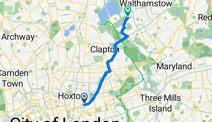
Szablon trasy
Z Bethnal Green do Walthamstow

- 39 min
- Czas
- 11,5 km
- Dystans
- 50 m
- Przewyższenia
- 47 m
- Spadek
- 17,8 km/h
- Śr. Prędkość
- 43 m
- Maks. wysokość
This ride takes you from Bethnal Green, a vibrant East London neighborhood known for its mix of historic spots (like the V&A Museum of Childhood) and cool cafes, up to the creative heart of Walthamstow. You’ll set out on mostly asphalt and paved paths, making the 11.5 km journey great for hybrid or road bikes.
You’ll weave through mostly quiet roads and dedicated cycleways, so it’s a chilled ride with barely any steep climbs (just under 50 meters of gentle ascent in total). Expect to cross Hackney and pass scenic parks like Hackney Downs, making it easy to grab a breather or a snack en route.
Walthamstow at your destination is famous for its street art, vintage markets, and the gorgeous Walthamstow Wetlands—a huge urban nature reserve perfect for a post-ride wander. All in all, it's a fun and mostly smooth ride linking two of East London’s liveliest neighborhoods!
Wspólnota
Najlepsi użytkownicy w tym regionie


Od naszej społeczności
Najlepsze trasy rowerowe z Bethnal Green do Walthamstow

footie to home
Trasa rowerowa w Bethnal Green, Anglia, Zjednoczone Królestwo Wielkiej Brytanii
- 9,8 km
- Dystans
- 34 m
- Przewyższenia
- 28 m
- Spadek

96 Newark St, London to Pastures Path, London
Trasa rowerowa w Bethnal Green, Anglia, Zjednoczone Królestwo Wielkiej Brytanii
- 8,3 km
- Dystans
- 24 m
- Przewyższenia
- 18 m
- Spadek
twins home
Trasa rowerowa w Bethnal Green, Anglia, Zjednoczone Królestwo Wielkiej Brytanii
- 7,5 km
- Dystans
- 16 m
- Przewyższenia
- 27 m
- Spadek
Senrab Street, London to St Mary Road, London
Trasa rowerowa w Bethnal Green, Anglia, Zjednoczone Królestwo Wielkiej Brytanii
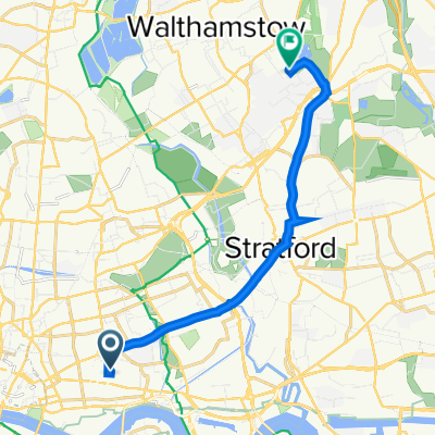
- 13,3 km
- Dystans
- 77 m
- Przewyższenia
- 57 m
- Spadek

49 Stepney City Apartments, Clark St, London to Hospital Road, London
Trasa rowerowa w Bethnal Green, Anglia, Zjednoczone Królestwo Wielkiej Brytanii
- 10,6 km
- Dystans
- 31 m
- Przewyższenia
- 22 m
- Spadek

Grove Road, London to Electricity Sub Station Rear Of Thistle Court, Bream Close, London
Trasa rowerowa w Bethnal Green, Anglia, Zjednoczone Królestwo Wielkiej Brytanii
- 8,3 km
- Dystans
- 31 m
- Przewyższenia
- 37 m
- Spadek

475 Cambridge Heath Road, London to 2 Forest Road, London
Trasa rowerowa w Bethnal Green, Anglia, Zjednoczone Królestwo Wielkiej Brytanii
- 7,7 km
- Dystans
- 59 m
- Przewyższenia
- 65 m
- Spadek

26 Baxendale St, London to 16 Vanguard Way, London
Trasa rowerowa w Bethnal Green, Anglia, Zjednoczone Królestwo Wielkiej Brytanii
- 8,6 km
- Dystans
- 121 m
- Przewyższenia
- 138 m
- Spadek

55 Clark St, London to Hospital Road, London
Trasa rowerowa w Bethnal Green, Anglia, Zjednoczone Królestwo Wielkiej Brytanii
- 10,3 km
- Dystans
- 56 m
- Przewyższenia
- 43 m
- Spadek

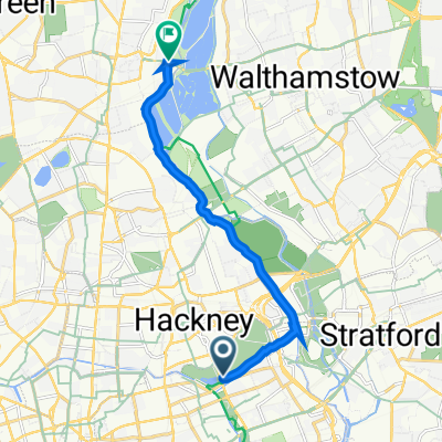
Whipps Cross Hospital
Trasa rowerowa w Bethnal Green, Anglia, Zjednoczone Królestwo Wielkiej Brytanii
- 11,1 km
- Dystans
- 47 m
- Przewyższenia
- 41 m
- Spadek

Recovered Route
Trasa rowerowa w Bethnal Green, Anglia, Zjednoczone Królestwo Wielkiej Brytanii
- 9,2 km
- Dystans
- 84 m
- Przewyższenia
- 93 m
- Spadek

East London, 15 Dec 2012
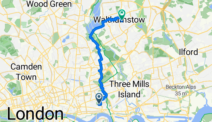
Trasa rowerowa w Bethnal Green, Anglia, Zjednoczone Królestwo Wielkiej Brytanii
- 16,1 km
- Dystans
- 65 m
- Przewyższenia
- 55 m
- Spadek
Odkryj więcej tras
 49 Stepney City Apartments, Clark St, London to Hospital Road, London
- Dystans
- 10,6 km
- Przewyższenia
- 31 m
- Spadek
- 22 m
- Lokalizacja
- Bethnal Green, Anglia, Zjednoczone Królestwo Wielkiej Brytanii
 Grove Road, London to Electricity Sub Station Rear Of Thistle Court, Bream Close, London
- Dystans
- 8,3 km
- Przewyższenia
- 31 m
- Spadek
- 37 m
- Lokalizacja
- Bethnal Green, Anglia, Zjednoczone Królestwo Wielkiej Brytanii
 475 Cambridge Heath Road, London to 2 Forest Road, London
- Dystans
- 7,7 km
- Przewyższenia
- 59 m
- Spadek
- 65 m
- Lokalizacja
- Bethnal Green, Anglia, Zjednoczone Królestwo Wielkiej Brytanii
 26 Baxendale St, London to 16 Vanguard Way, London
- Dystans
- 8,6 km
- Przewyższenia
- 121 m
- Spadek
- 138 m
- Lokalizacja
- Bethnal Green, Anglia, Zjednoczone Królestwo Wielkiej Brytanii
 55 Clark St, London to Hospital Road, London
- Dystans
- 10,3 km
- Przewyższenia
- 56 m
- Spadek
- 43 m
- Lokalizacja
- Bethnal Green, Anglia, Zjednoczone Królestwo Wielkiej Brytanii
 Whipps Cross Hospital
- Dystans
- 11,1 km
- Przewyższenia
- 47 m
- Spadek
- 41 m
- Lokalizacja
- Bethnal Green, Anglia, Zjednoczone Królestwo Wielkiej Brytanii
 Recovered Route
- Dystans
- 9,2 km
- Przewyższenia
- 84 m
- Spadek
- 93 m
- Lokalizacja
- Bethnal Green, Anglia, Zjednoczone Królestwo Wielkiej Brytanii
 East London, 15 Dec 2012
- Dystans
- 16,1 km
- Przewyższenia
- 65 m
- Spadek
- 55 m
- Lokalizacja
- Bethnal Green, Anglia, Zjednoczone Królestwo Wielkiej Brytanii
Trasy z Bethnal Green
Szybka przejażdżka rowerowa od
Z Bethnal Green do Canary Wharf
Szybka przejażdżka rowerowa od
Z Bethnal Green do Clerkenwell
Trasy do Walthamstow
Szybka przejażdżka rowerowa od
Z Woodford Green do Walthamstow
Szybka przejażdżka rowerowa od
Z Harringay do Walthamstow