
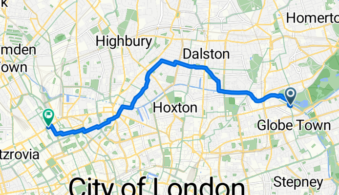
Szybka przejażdżka rowerowa z Bethnal Green do Clerkenwell
Dostosuj własną trasę na podstawie naszego szablonu lub zobacz, jak nasza społeczność najchętniej jeździ z Bethnal Green do Clerkenwell.
Szablon trasy
Z Bethnal Green do Clerkenwell

- 23 min
- Czas
- 6,7 km
- Dystans
- 32 m
- Przewyższenia
- 24 m
- Spadek
- 17,7 km/h
- Śr. Prędkość
- 38 m
- Maks. wysokość
This ride takes you from the heart of Bethnal Green—East London’s vibrant, ever-changing community—over to Clerkenwell, known for its creative scene and historic streets. Setting off, you’ll mostly stick to quiet roads (excellent for a stress-free spin), cruising past a mix of classic Victorian terraces and trendy warehouse conversions. The route is a gentle one, with just enough ascent to keep things interesting but not too demanding on the legs.
Surface-wise, you’re rolling almost entirely on smooth asphalt and other paved roads, so expect an easy ride for any type of bike. The ride winds through some cool neighborhoods—think street markets, indie cafés, and a snapshot or two of city life—before landing you in Clerkenwell, an old center of monastic orders and now buzzing with coffee shops, gastropubs, and design studios.
If you’re after a ride that’s urban, lively, and pretty chill, this little journey from Bethnal Green to Clerkenwell will deliver. Perfect for a commute, a weekend jaunt, or a scenic spin to a café!
Wspólnota
Najlepsi użytkownicy w tym regionie


Od naszej społeczności
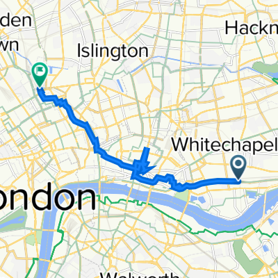
Najlepsze trasy rowerowe z Bethnal Green do Clerkenwell
Sewardstone Road, London to Euston Road, London
Trasa rowerowa w Bethnal Green, Anglia, Zjednoczone Królestwo Wielkiej Brytanii
- 7,8 km
- Dystans
- 54 m
- Przewyższenia
- 49 m
- Spadek

119 Old Ford Road, London to 19 Brownlow St, London
Trasa rowerowa w Bethnal Green, Anglia, Zjednoczone Królestwo Wielkiej Brytanii
- 6,3 km
- Dystans
- 31 m
- Przewyższenia
- 14 m
- Spadek

Recovered Route
Trasa rowerowa w Bethnal Green, Anglia, Zjednoczone Królestwo Wielkiej Brytanii
- 6,2 km
- Dystans
- 101 m
- Przewyższenia
- 77 m
- Spadek

2A Palmers Road, London to 35-38 Chancery Lane, London
Trasa rowerowa w Bethnal Green, Anglia, Zjednoczone Królestwo Wielkiej Brytanii
- 6 km
- Dystans
- 23 m
- Przewyższenia
- 17 m
- Spadek

247–255 Cable St, London to st pancras
Trasa rowerowa w Bethnal Green, Anglia, Zjednoczone Królestwo Wielkiej Brytanii
- 8,6 km
- Dystans
- 70 m
- Przewyższenia
- 61 m
- Spadek

138 Old Ford Road, London to 50-51 Brownlow House, High Holborn, London
Trasa rowerowa w Bethnal Green, Anglia, Zjednoczone Królestwo Wielkiej Brytanii
- 6,8 km
- Dystans
- 76 m
- Przewyższenia
- 67 m
- Spadek

33 Mare St, London to St John's Gardens, Benjamin St, London
Trasa rowerowa w Bethnal Green, Anglia, Zjednoczone Królestwo Wielkiej Brytanii
- 4,9 km
- Dystans
- 15 m
- Przewyższenia
- 19 m
- Spadek

136 Old Ford Road, London to 1–99 Hand Ct, London
Trasa rowerowa w Bethnal Green, Anglia, Zjednoczone Królestwo Wielkiej Brytanii
- 6,8 km
- Dystans
- 86 m
- Przewyższenia
- 76 m
- Spadek

62 Commercial Road, London nach 2 Doughty St, London
Trasa rowerowa w Bethnal Green, Anglia, Zjednoczone Królestwo Wielkiej Brytanii
- 4,7 km
- Dystans
- 20 m
- Przewyższenia
- 9 m
- Spadek

22A Mare St, London to St John's Gardens, Benjamin St, London
Trasa rowerowa w Bethnal Green, Anglia, Zjednoczone Królestwo Wielkiej Brytanii
- 4,8 km
- Dystans
- 36 m
- Przewyższenia
- 39 m
- Spadek

85-89 Warner Pl, London to 19 Theobald's Road, London
Trasa rowerowa w Bethnal Green, Anglia, Zjednoczone Królestwo Wielkiej Brytanii
- 4,2 km
- Dystans
- 28 m
- Przewyższenia
- 3 m
- Spadek

51.531° N -0.040° W to 51.516° N -0.112° W
Trasa rowerowa w Bethnal Green, Anglia, Zjednoczone Królestwo Wielkiej Brytanii
- 6,2 km
- Dystans
- 27 m
- Przewyższenia
- 21 m
- Spadek
Odkryj więcej tras
 247–255 Cable St, London to st pancras
- Dystans
- 8,6 km
- Przewyższenia
- 70 m
- Spadek
- 61 m
- Lokalizacja
- Bethnal Green, Anglia, Zjednoczone Królestwo Wielkiej Brytanii
 138 Old Ford Road, London to 50-51 Brownlow House, High Holborn, London
- Dystans
- 6,8 km
- Przewyższenia
- 76 m
- Spadek
- 67 m
- Lokalizacja
- Bethnal Green, Anglia, Zjednoczone Królestwo Wielkiej Brytanii
 33 Mare St, London to St John's Gardens, Benjamin St, London
- Dystans
- 4,9 km
- Przewyższenia
- 15 m
- Spadek
- 19 m
- Lokalizacja
- Bethnal Green, Anglia, Zjednoczone Królestwo Wielkiej Brytanii
 136 Old Ford Road, London to 1–99 Hand Ct, London
- Dystans
- 6,8 km
- Przewyższenia
- 86 m
- Spadek
- 76 m
- Lokalizacja
- Bethnal Green, Anglia, Zjednoczone Królestwo Wielkiej Brytanii
 62 Commercial Road, London nach 2 Doughty St, London
- Dystans
- 4,7 km
- Przewyższenia
- 20 m
- Spadek
- 9 m
- Lokalizacja
- Bethnal Green, Anglia, Zjednoczone Królestwo Wielkiej Brytanii
 22A Mare St, London to St John's Gardens, Benjamin St, London
- Dystans
- 4,8 km
- Przewyższenia
- 36 m
- Spadek
- 39 m
- Lokalizacja
- Bethnal Green, Anglia, Zjednoczone Królestwo Wielkiej Brytanii
 85-89 Warner Pl, London to 19 Theobald's Road, London
- Dystans
- 4,2 km
- Przewyższenia
- 28 m
- Spadek
- 3 m
- Lokalizacja
- Bethnal Green, Anglia, Zjednoczone Królestwo Wielkiej Brytanii
 51.531° N -0.040° W to 51.516° N -0.112° W
- Dystans
- 6,2 km
- Przewyższenia
- 27 m
- Spadek
- 21 m
- Lokalizacja
- Bethnal Green, Anglia, Zjednoczone Królestwo Wielkiej Brytanii
Trasy z Bethnal Green
Szybka przejażdżka rowerowa od
Z Bethnal Green do Islington
Szybka przejażdżka rowerowa od
Z Bethnal Green do Canary Wharf
Trasy do Clerkenwell
Jednodniowa wycieczka rowerowa od
Z Wembley do Clerkenwell
Szybka przejażdżka rowerowa od
Z Camberwell do Clerkenwell
Szybka przejażdżka rowerowa od
Z Londyn do Clerkenwell