
Bikepacking z Taitung City do Hengchun
Dostosuj własną trasę na podstawie naszego szablonu lub zobacz, jak nasza społeczność najchętniej jeździ z Taitung City do Hengchun.
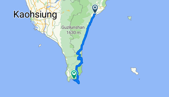
Szablon trasy
Z Taitung City do Hengchun

- 13 h 13 min
- Czas
- 193 km
- Dystans
- 8056 m
- Przewyższenia
- 8048 m
- Spadek
- 14,6 km/h
- Śr. Prędkość
- 1042 m
- Maks. wysokość
Get ready for a truly epic cycling adventure! Starting in the laid-back coastal city of Taitung—famous for its vibrant Indigenous culture, easy-going pace, and views of the Pacific—you’ll be pedaling almost 193 km all the way to Hengchun, the historic gateway to Kenting National Park at the southern tip of Taiwan.
This is no ordinary ride: you’ll climb over 8000 meters in total, with some hefty ascents through lush mountains, high plateaus, and rolling farmland. The route is refreshingly quiet, mostly country roads and tracks, offering those classic East Coast vistas—towering cliffs to one side, endless ocean to the other. Expect the surface to be a bit of a mixed bag, mostly paved but with a need to stay alert for concrete patches and the occasional bumpier stretch.
Reaching Hengchun feels like a reward: it’s an old walled town brimming with history, and just a stone’s throw from the beaches and coral reefs of Kenting. This is a long, challenging route, perfect for adventure-seekers looking to experience Taiwan’s wild side on two wheels!
Wspólnota
Najlepsi użytkownicy w tym regionie


Od naszej społeczności
Najlepsze trasy rowerowe z Taitung City do Hengchun

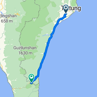
腳踏車環島第六天-南迴壽卡 夜衝墾丁
Trasa rowerowa w Taitung City, Taiwan, Tajwan
- 156,4 km
- Dystans
- 1012 m
- Przewyższenia
- 1014 m
- Spadek

Day5 TaitungTaimali to Hengchun
Trasa rowerowa w Taitung City, Taiwan, Tajwan
- 131,6 km
- Dystans
- 896 m
- Przewyższenia
- 916 m
- Spadek

Day 5 -1
Trasa rowerowa w Taitung City, Taiwan, Tajwan
- 153,1 km
- Dystans
- 923 m
- Przewyższenia
- 934 m
- Spadek

Day 4 2/5 Taitung-Kenting
Trasa rowerowa w Taitung City, Taiwan, Tajwan
- 151,4 km
- Dystans
- 1008 m
- Przewyższenia
- 999 m
- Spadek


Day 4 : 台東 至 牡丹鄉
Trasa rowerowa w Taitung City, Taiwan, Tajwan
- 102,9 km
- Dystans
- 706 m
- Przewyższenia
- 633 m
- Spadek

Taiwan J12: Taitung - Shouka
Trasa rowerowa w Taitung City, Taiwan, Tajwan
- 73,3 km
- Dystans
- 784 m
- Przewyższenia
- 373 m
- Spadek

Zhiben-Sichongxi Damei Road No 1-7
Trasa rowerowa w Taitung City, Taiwan, Tajwan
- 98,3 km
- Dystans
- 734 m
- Przewyższenia
- 727 m
- Spadek
Day5-知本-大武-墾丁
Trasa rowerowa w Taitung City, Taiwan, Tajwan
- 141,9 km
- Dystans
- 1026 m
- Przewyższenia
- 1044 m
- Spadek


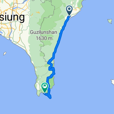
Taitung-kenting
Trasa rowerowa w Taitung City, Taiwan, Tajwan
- 142,6 km
- Dystans
- 965 m
- Przewyższenia
- 966 m
- Spadek
Odkryj więcej tras
 T10 Morz
- Dystans
- 125 km
- Przewyższenia
- 874 m
- Spadek
- 871 m
- Lokalizacja
- Taitung City, Taiwan, Tajwan
 05 台東 墾丁
- Dystans
- 146,3 km
- Przewyższenia
- 1009 m
- Spadek
- 1014 m
- Lokalizacja
- Taitung City, Taiwan, Tajwan
 Day 4 : 台東 至 牡丹鄉
- Dystans
- 102,9 km
- Przewyższenia
- 706 m
- Spadek
- 633 m
- Lokalizacja
- Taitung City, Taiwan, Tajwan
 Taiwan J12: Taitung - Shouka
- Dystans
- 73,3 km
- Przewyższenia
- 784 m
- Spadek
- 373 m
- Lokalizacja
- Taitung City, Taiwan, Tajwan
 Zhiben-Sichongxi Damei Road No 1-7
- Dystans
- 98,3 km
- Przewyższenia
- 734 m
- Spadek
- 727 m
- Lokalizacja
- Taitung City, Taiwan, Tajwan
 Day5-知本-大武-墾丁
- Dystans
- 141,9 km
- Przewyższenia
- 1026 m
- Spadek
- 1044 m
- Lokalizacja
- Taitung City, Taiwan, Tajwan
 台東到墾丁
台東到墾丁- Dystans
- 153,4 km
- Przewyższenia
- 1012 m
- Spadek
- 1014 m
- Lokalizacja
- Taitung City, Taiwan, Tajwan
 Taitung-kenting
- Dystans
- 142,6 km
- Przewyższenia
- 965 m
- Spadek
- 966 m
- Lokalizacja
- Taitung City, Taiwan, Tajwan
Trasy z Taitung City
Bikepacking od
Z Taitung City do Hualien City
Rowerowa od
Z Taitung City do Taitung
Trasy do Hengchun
Bikepacking od
Z Tainan do Hengchun
Bikepacking od
Z Taitung do Hengchun
Jednodniowa wycieczka rowerowa od
Z Pingtung do Hengchun
Jednodniowa wycieczka rowerowa od
Z Kaohsiung do Hengchun