
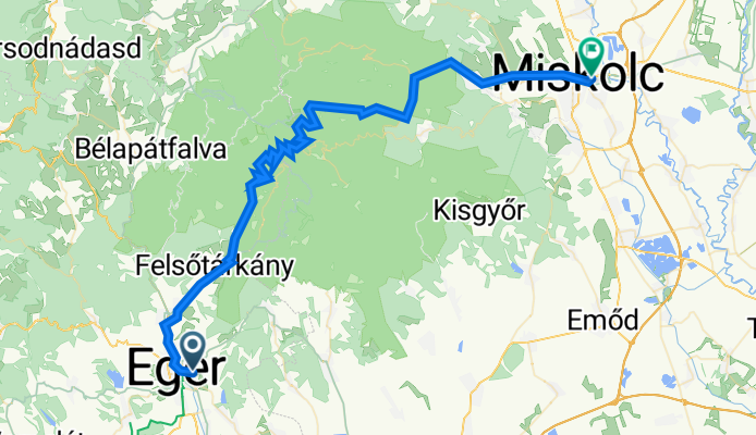
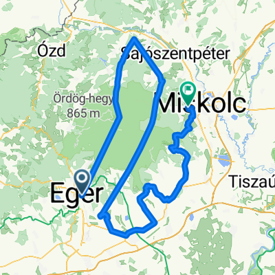
Szablon trasy
Z Eger do Miszkolc

- 5 h
- Czas
- 73,8 km
- Dystans
- 1454 m
- Przewyższenia
- 1485 m
- Spadek
- 14,7 km/h
- Śr. Prędkość
- 479 m
- Maks. wysokość
This ride takes you from the historic town of Eger to Miskolc, winding through about 74 km of Northern Hungary’s beautiful countryside. Eger, famous for its baroque architecture, thermal baths, and the iconic Eger Castle, is a great spot to start your adventure.
You’ll enjoy quiet scenic roads and dedicated cycleways for much of the route, cutting through forests and rolling hills with some serious up-and-down action—expect to climb nearly 1,450 meters! Surfaces are varied, with some stretches of smooth asphalt, paved roads, and the occasional gravel or unpaved section, so a sturdy bike is recommended.
As you approach Miskolc, the largest city in the region, look forward to more urban surroundings and maybe a visit to the unique Cave Bath in neighboring Miskolctapolca. All in all, this is a challenging but rewarding ride that shows off the charm and natural beauty of Northern Hungary—perfect for adventurous cyclists who don’t mind a few hills!
Wspólnota
Najlepsi użytkownicy w tym regionie


Od naszej społeczności
Najlepsze trasy rowerowe z Eger do Miszkolc

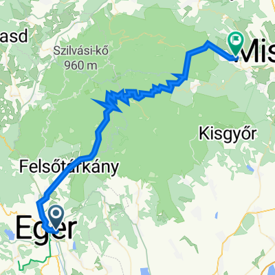
Route to Miskolc
Trasa rowerowa w Eger, Komitat Heves, Węgry
- 65,9 km
- Dystans
- 1270 m
- Przewyższenia
- 1317 m
- Spadek

Bükkös - kerekes
Trasa rowerowa w Eger, Komitat Heves, Węgry
- 67,2 km
- Dystans
- ---
- Przewyższenia
- ---
- Spadek

11.EGER-MISKOLCZ
Trasa rowerowa w Eger, Komitat Heves, Węgry
- 65,2 km
- Dystans
- 677 m
- Przewyższenia
- 727 m
- Spadek

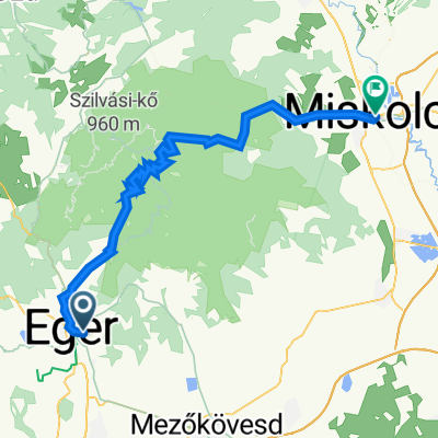
eger-miskolc
Trasa rowerowa w Eger, Komitat Heves, Węgry
- 67,2 km
- Dystans
- 817 m
- Przewyższenia
- 857 m
- Spadek

01. Eger-Miskolc
Trasa rowerowa w Eger, Komitat Heves, Węgry
- 65,7 km
- Dystans
- 601 m
- Przewyższenia
- 667 m
- Spadek
Rozália utca 24, Eger - Éder György utca 12, Miskolc
Trasa rowerowa w Eger, Komitat Heves, Węgry
- 68,6 km
- Dystans
- 810 m
- Przewyższenia
- 933 m
- Spadek

Rozália utca - Békeszálló telep
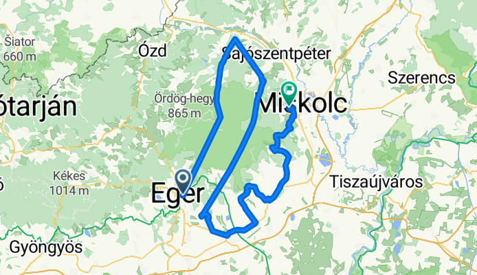
Trasa rowerowa w Eger, Komitat Heves, Węgry
- 169,7 km
- Dystans
- 3068 m
- Przewyższenia
- 3184 m
- Spadek

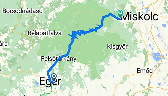
Eger-Bükk-Miskolc
Trasa rowerowa w Eger, Komitat Heves, Węgry
- 67,1 km
- Dystans
- 823 m
- Przewyższenia
- 866 m
- Spadek
Rozália utca 24, Eger - Kiss tábornok út 54, Miskolc
Trasa rowerowa w Eger, Komitat Heves, Węgry
- 57 km
- Dystans
- 609 m
- Przewyższenia
- 637 m
- Spadek

Eger - Kandó Kálmán tér 1, Miskolc
Trasa rowerowa w Eger, Komitat Heves, Węgry
- 98,7 km
- Dystans
- 2337 m
- Przewyższenia
- 2379 m
- Spadek

Bükk Eger Miskolc
Trasa rowerowa w Eger, Komitat Heves, Węgry
- 104,2 km
- Dystans
- 1235 m
- Przewyższenia
- 1223 m
- Spadek
Odkryj więcej tras
 01. Eger-Miskolc
- Dystans
- 65,7 km
- Przewyższenia
- 601 m
- Spadek
- 667 m
- Lokalizacja
- Eger, Komitat Heves, Węgry
 Rozália utca 24, Eger - Éder György utca 12, Miskolc
- Dystans
- 68,6 km
- Przewyższenia
- 810 m
- Spadek
- 933 m
- Lokalizacja
- Eger, Komitat Heves, Węgry
 Eger-Miskolc
- Dystans
- 56,9 km
- Przewyższenia
- 700 m
- Spadek
- 738 m
- Lokalizacja
- Eger, Komitat Heves, Węgry
 Rozália utca - Békeszálló telep
- Dystans
- 169,7 km
- Przewyższenia
- 3068 m
- Spadek
- 3184 m
- Lokalizacja
- Eger, Komitat Heves, Węgry
 Eger-Bükk-Miskolc
- Dystans
- 67,1 km
- Przewyższenia
- 823 m
- Spadek
- 866 m
- Lokalizacja
- Eger, Komitat Heves, Węgry
 Rozália utca 24, Eger - Kiss tábornok út 54, Miskolc
- Dystans
- 57 km
- Przewyższenia
- 609 m
- Spadek
- 637 m
- Lokalizacja
- Eger, Komitat Heves, Węgry
 Eger - Kandó Kálmán tér 1, Miskolc
- Dystans
- 98,7 km
- Przewyższenia
- 2337 m
- Spadek
- 2379 m
- Lokalizacja
- Eger, Komitat Heves, Węgry
 Bükk Eger Miskolc
- Dystans
- 104,2 km
- Przewyższenia
- 1235 m
- Spadek
- 1223 m
- Lokalizacja
- Eger, Komitat Heves, Węgry
Trasy z Eger
Jednodniowa wycieczka rowerowa od
Z Eger do Szilvásvárad
Rowerowa od
Z Eger do Felsőtárkány
Trasy do Miszkolc
Rowerowa od
Z Sajóbábony do Miszkolc