
Szybka przejażdżka rowerowa z Pasig City do Makati City
Dostosuj własną trasę na podstawie naszego szablonu lub zobacz, jak nasza społeczność najchętniej jeździ z Pasig City do Makati City.
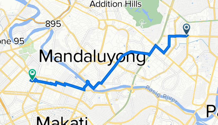
Szablon trasy
Z Pasig City do Makati City

- 1 h 7 min
- Czas
- 18,3 km
- Dystans
- 191 m
- Przewyższenia
- 241 m
- Spadek
- 16,3 km/h
- Śr. Prędkość
- 84 m
- Maks. wysokość
If you’re looking for a solid city ride, this Pasig to Makati route is a perfect pick. Starting off in Pasig—a bustling hub along the Pasig River known for its lively marketplaces and historic sites—you’ll cruise through roughly 18 kilometers of Metro Manila’s urban landscape. Most of this ride is on smooth, paved roads, with a pleasant mix of quiet sidestreets (about 70% of the way), letting you mostly avoid the crazy traffic of EDSA or C5.
You’ll notice the occasional uphill section, especially early on, but nothing too serious—save some breath for a total ascent of about 190 meters. Enjoy the little downs as you roll closer to Makati. Once you hit Makati City, you’ll be right in the heart of the country’s major financial district, lined with skyscrapers, trendy cafes, and green pockets like Ayala Triangle Gardens. Whether you’re commuting, exploring, or just getting some urban miles in, this ride is a great way to see two sides of Metro Manila—historic Pasig and cosmopolitan Makati.
Wspólnota
Najlepsi użytkownicy w tym regionie


Od naszej społeczności
Najlepsze trasy rowerowe z Pasig City do Makati City

Home to Valero
Trasa rowerowa w Pasig City, National Capital Region, Filipiny
- 9,8 km
- Dystans
- 120 m
- Przewyższenia
- 75 m
- Spadek

via Buendia
Trasa rowerowa w Pasig City, National Capital Region, Filipiny
- 8 km
- Dystans
- 29 m
- Przewyższenia
- 60 m
- Spadek

Pasig Boulevard, Pasig City to Lane O, Makati City
Trasa rowerowa w Pasig City, National Capital Region, Filipiny
- 3,9 km
- Dystans
- 36 m
- Przewyższenia
- 46 m
- Spadek

Route to General Aguinaldo Street 3054, Taguig
Trasa rowerowa w Pasig City, National Capital Region, Filipiny
- 2,8 km
- Dystans
- 82 m
- Przewyższenia
- 138 m
- Spadek

Pearl Street 24, Pasig to Dela Rosa, Makati
Trasa rowerowa w Pasig City, National Capital Region, Filipiny
- 13,3 km
- Dystans
- 96 m
- Przewyższenia
- 96 m
- Spadek

Topaz 36, Pasig to V.A. Rufino Street 110, Makati
Trasa rowerowa w Pasig City, National Capital Region, Filipiny
- 11,1 km
- Dystans
- 96 m
- Przewyższenia
- 86 m
- Spadek
work to home
Trasa rowerowa w Pasig City, National Capital Region, Filipiny
- 7,5 km
- Dystans
- 74 m
- Przewyższenia
- 108 m
- Spadek

CHILL RIDE
Trasa rowerowa w Pasig City, National Capital Region, Filipiny
- 21,6 km
- Dystans
- 135 m
- Przewyższenia
- 138 m
- Spadek

Corporal Cruz, Pasig to Osmeña Highway, Makati
Trasa rowerowa w Pasig City, National Capital Region, Filipiny
- 12,8 km
- Dystans
- 122 m
- Przewyższenia
- 120 m
- Spadek

Suarez 1216-A, Pasig to Enrique Street 4942, Makati
Trasa rowerowa w Pasig City, National Capital Region, Filipiny
- 15,6 km
- Dystans
- 223 m
- Przewyższenia
- 266 m
- Spadek

Doña Julia Vargas Avenue, Mandaluyong to Taft Avenue, Pasay
Trasa rowerowa w Pasig City, National Capital Region, Filipiny
- 16,8 km
- Dystans
- 298 m
- Przewyższenia
- 331 m
- Spadek

Fairlane, Pasig to 169 Tupas Street, Pasay
Trasa rowerowa w Pasig City, National Capital Region, Filipiny
- 10,6 km
- Dystans
- 82 m
- Przewyższenia
- 96 m
- Spadek
Odkryj więcej tras
 Pearl Street 24, Pasig to Dela Rosa, Makati
- Dystans
- 13,3 km
- Przewyższenia
- 96 m
- Spadek
- 96 m
- Lokalizacja
- Pasig City, National Capital Region, Filipiny
 Topaz 36, Pasig to V.A. Rufino Street 110, Makati
- Dystans
- 11,1 km
- Przewyższenia
- 96 m
- Spadek
- 86 m
- Lokalizacja
- Pasig City, National Capital Region, Filipiny
 work to home
- Dystans
- 7,5 km
- Przewyższenia
- 74 m
- Spadek
- 108 m
- Lokalizacja
- Pasig City, National Capital Region, Filipiny
 CHILL RIDE
- Dystans
- 21,6 km
- Przewyższenia
- 135 m
- Spadek
- 138 m
- Lokalizacja
- Pasig City, National Capital Region, Filipiny
 Corporal Cruz, Pasig to Osmeña Highway, Makati
- Dystans
- 12,8 km
- Przewyższenia
- 122 m
- Spadek
- 120 m
- Lokalizacja
- Pasig City, National Capital Region, Filipiny
 Suarez 1216-A, Pasig to Enrique Street 4942, Makati
- Dystans
- 15,6 km
- Przewyższenia
- 223 m
- Spadek
- 266 m
- Lokalizacja
- Pasig City, National Capital Region, Filipiny
 Doña Julia Vargas Avenue, Mandaluyong to Taft Avenue, Pasay
- Dystans
- 16,8 km
- Przewyższenia
- 298 m
- Spadek
- 331 m
- Lokalizacja
- Pasig City, National Capital Region, Filipiny
 Fairlane, Pasig to 169 Tupas Street, Pasay
- Dystans
- 10,6 km
- Przewyższenia
- 82 m
- Spadek
- 96 m
- Lokalizacja
- Pasig City, National Capital Region, Filipiny
Trasy z Pasig City
Szybka przejażdżka rowerowa od
Z Pasig City do Mandaluyong
Szybka przejażdżka rowerowa od
Z Pasig City do Pateros
Trasy do Makati City
Jednodniowa wycieczka rowerowa od
Z Imus do Makati City
Jednodniowa wycieczka rowerowa od
Z Dasmariñas do Makati City
Szybka przejażdżka rowerowa od
Z Del Monte do Makati City
Szybka przejażdżka rowerowa od
Z Taguig do Makati City