
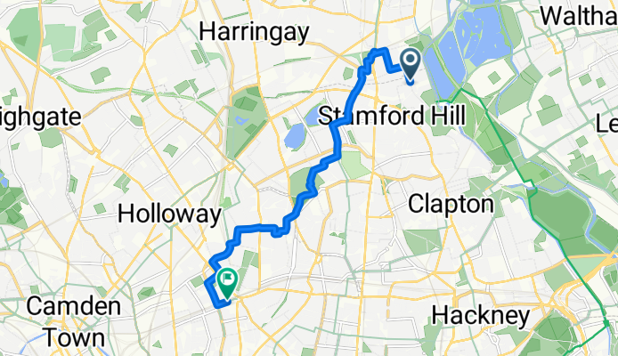
Szablon trasy
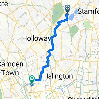
Z Harringay do Barnsbury

- 36 min
- Czas
- 10,5 km
- Dystans
- 72 m
- Przewyższenia
- 62 m
- Spadek
- 17,7 km/h
- Śr. Prędkość
- 66 m
- Maks. wysokość
This is a steady city ride that starts in lively Harringay, a North London neighborhood known for its bustling Green Lanes food scene and diverse community. You’ll wind your way south for just over 10 km to reach Barnsbury, an elegant corner of Islington with leafy Victorian terraces and quiet streets.
The route is mostly on quiet roads (a chill 71%) with a decent stretch of proper cycleways (22%), so you should have a pleasant ride, and only a tiny bit (1%) on busy roads. The surface is mostly paved or asphalt, so no need for a mountain bike here. You’ll get a bit of a workout with around 72 meters of ascent, but nothing too intense, maxing out under 66 meters elevation.
Barnsbury at the finish is perfect for grabbing a coffee or a picnic in one of the local garden squares—just a relaxed urban spin with a bit of north-to-central London flavor!
Wspólnota
Najlepsi użytkownicy w tym regionie


Od naszej społeczności
Najlepsze trasy rowerowe z Harringay do Barnsbury

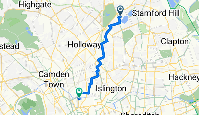
Goodchild Road to Pancras Square 6
Trasa rowerowa w Harringay, Anglia, Zjednoczone Królestwo Wielkiej Brytanii
- 8,3 km
- Dystans
- 24 m
- Przewyższenia
- 80 m
- Spadek

Hartingtons Court, Coster Ave, London to York Way, London
Trasa rowerowa w Harringay, Anglia, Zjednoczone Królestwo Wielkiej Brytanii
- 6 km
- Dystans
- 32 m
- Przewyższenia
- 38 m
- Spadek

254 Nathaniel Court, Green Lanes, London to 90 York Way, London
Trasa rowerowa w Harringay, Anglia, Zjednoczone Królestwo Wielkiej Brytanii
- 6,1 km
- Dystans
- 24 m
- Przewyższenia
- 48 m
- Spadek

Green Lanes to Roman Way 149
Trasa rowerowa w Harringay, Anglia, Zjednoczone Królestwo Wielkiej Brytanii
- 4 km
- Dystans
- 21 m
- Przewyższenia
- 54 m
- Spadek

Hartingtons Court, Coster Ave, London to 6–8 Crinan St, London
Trasa rowerowa w Harringay, Anglia, Zjednoczone Królestwo Wielkiej Brytanii
- 5,8 km
- Dystans
- 25 m
- Przewyższenia
- 39 m
- Spadek

Hartingtons Court, Coster Ave, London to 90 York Way, London
Trasa rowerowa w Harringay, Anglia, Zjednoczone Królestwo Wielkiej Brytanii
- 6,6 km
- Dystans
- 23 m
- Przewyższenia
- 31 m
- Spadek

London to Euston Road
Trasa rowerowa w Harringay, Anglia, Zjednoczone Królestwo Wielkiej Brytanii
- 7,2 km
- Dystans
- 35 m
- Przewyższenia
- 39 m
- Spadek

232 Green Lanes, London to 6–8 Crinan St, London
Trasa rowerowa w Harringay, Anglia, Zjednoczone Królestwo Wielkiej Brytanii
- 5,6 km
- Dystans
- 27 m
- Przewyższenia
- 37 m
- Spadek

254 Nathaniel Court, Green Lanes, London to 6–8 Crinan St, London
Trasa rowerowa w Harringay, Anglia, Zjednoczone Królestwo Wielkiej Brytanii
- 5,8 km
- Dystans
- 23 m
- Przewyższenia
- 36 m
- Spadek

Hartingtons Court, Coster Ave, London to 90 York Way, London
Trasa rowerowa w Harringay, Anglia, Zjednoczone Królestwo Wielkiej Brytanii
- 6 km
- Dystans
- 34 m
- Przewyższenia
- 45 m
- Spadek
dom benny
Trasa rowerowa w Harringay, Anglia, Zjednoczone Królestwo Wielkiej Brytanii
- 7,8 km
- Dystans
- 93 m
- Przewyższenia
- 121 m
- Spadek
Hartingtons Court, Coster Ave, London to 6–8 Crinan St, London
Trasa rowerowa w Harringay, Anglia, Zjednoczone Królestwo Wielkiej Brytanii
- 5,8 km
- Dystans
- 30 m
- Przewyższenia
- 40 m
- Spadek
Odkryj więcej tras
 Hartingtons Court, Coster Ave, London to 6–8 Crinan St, London
- Dystans
- 5,8 km
- Przewyższenia
- 25 m
- Spadek
- 39 m
- Lokalizacja
- Harringay, Anglia, Zjednoczone Królestwo Wielkiej Brytanii
 Hartingtons Court, Coster Ave, London to 90 York Way, London
- Dystans
- 6,6 km
- Przewyższenia
- 23 m
- Spadek
- 31 m
- Lokalizacja
- Harringay, Anglia, Zjednoczone Królestwo Wielkiej Brytanii
 London to Euston Road
- Dystans
- 7,2 km
- Przewyższenia
- 35 m
- Spadek
- 39 m
- Lokalizacja
- Harringay, Anglia, Zjednoczone Królestwo Wielkiej Brytanii
 232 Green Lanes, London to 6–8 Crinan St, London
- Dystans
- 5,6 km
- Przewyższenia
- 27 m
- Spadek
- 37 m
- Lokalizacja
- Harringay, Anglia, Zjednoczone Królestwo Wielkiej Brytanii
 254 Nathaniel Court, Green Lanes, London to 6–8 Crinan St, London
- Dystans
- 5,8 km
- Przewyższenia
- 23 m
- Spadek
- 36 m
- Lokalizacja
- Harringay, Anglia, Zjednoczone Królestwo Wielkiej Brytanii
 Hartingtons Court, Coster Ave, London to 90 York Way, London
- Dystans
- 6 km
- Przewyższenia
- 34 m
- Spadek
- 45 m
- Lokalizacja
- Harringay, Anglia, Zjednoczone Królestwo Wielkiej Brytanii
 dom benny
- Dystans
- 7,8 km
- Przewyższenia
- 93 m
- Spadek
- 121 m
- Lokalizacja
- Harringay, Anglia, Zjednoczone Królestwo Wielkiej Brytanii
 Hartingtons Court, Coster Ave, London to 6–8 Crinan St, London
- Dystans
- 5,8 km
- Przewyższenia
- 30 m
- Spadek
- 40 m
- Lokalizacja
- Harringay, Anglia, Zjednoczone Królestwo Wielkiej Brytanii
Trasy z Harringay
Rowerowa od
Z Harringay do Hackney
Rowerowa od
Z Harringay do City of London
Trasy do Barnsbury
Rowerowa od
Z Wood Green do Barnsbury
Rowerowa od
Z Islington do Barnsbury