
![Ph0]에서 경로석사동 77, 춘천시](https://media.bikemap.net/routes/13458209/staticmaps/in_81aaafde-f167-4275-87ad-0cd50dbb8de1_694x400_bikemap-2021-3D-static.png)

![Ph0]에서 경로석사동 77, 춘천시](https://media.bikemap.net/routes/13334614/staticmaps/in_0c39e7a6-22bf-45b5-a079-778a7e916ec5_694x400_bikemap-2021-3D-static.png)
![Ph0]에서 경로석사동 77, 춘천시](https://media.bikemap.net/routes/13474509/staticmaps/in_2b56604b-2c3c-4315-9258-ac80a8827a5b_694x400_bikemap-2021-3D-static.png)
![Ph0]에서 경로석사동 77, 춘천시](https://media.bikemap.net/routes/13322489/staticmaps/in_801fe1a9-4756-4d13-9218-73146d3cdd52_694x400_bikemap-2021-3D-static.png)


![Ph0]에서 경로석사동 77, 춘천시](https://media.bikemap.net/routes/13413110/staticmaps/in_e3dca468-bfba-4883-9888-f9c1c87e34fe_694x400_bikemap-2021-3D-static.png)

![Ph0]에서 경로동내면 산52-2](https://media.bikemap.net/routes/18020754/staticmaps/in_9ee3ae4f-2549-4f97-b041-f3576250ca67_694x400_bikemap-2021-3D-static.png)
![Ph0]에서 경로석사동 77, 춘천시](https://media.bikemap.net/routes/13334614/staticmaps/in_0c39e7a6-22bf-45b5-a079-778a7e916ec5_400x400_bikemap-2021-3D-static.png)
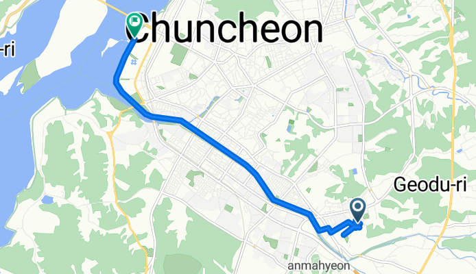
Ph0]에서 경로석사동 77, 춘천시
- 8 km
- 11 m
- 84 m
- Dongnae, Gangwon, Korea Południowa

Szablon trasy

Spin from Dongnae to Chuncheon on an easy, mostly flat ride that clocks in at about 7.8 km. The route leans heavily on dedicated cycleways (roughly three-quarters of the way), with short links on quiet roads—almost entirely paved—so it’s friendly for casual riders and families. Expect only gentle ups and downs (around 44 m of climbing), with low overall elevation.
You’ll roll northwest through calm neighborhoods toward central Chuncheon, with chances to detour into riverside and park paths if you want a breather. Chuncheon is the capital of Gangwon-do and a longtime favorite for weekenders—famous for dakgalbi and buckwheat makguksu, plus lakeside scenery around Uiam Lake and the Soyang area.
Finish up near the city center and treat yourself: Myeongdong Dakgalbi Street isn’t far if you’re hungry, and there are plenty of cafés for a quick coffee. Tips: bring lights for any underpasses, mind a few road crossings, and enjoy the smooth cruise.
Wspólnota
Od naszej społeczności
Trasa rowerowa w Dongnae, Gangwon, Korea Południowa
Trasa rowerowa w Dongnae, Gangwon, Korea Południowa
Trasa rowerowa w Dongnae, Gangwon, Korea Południowa
Trasa rowerowa w Dongnae, Gangwon, Korea Południowa
Trasa rowerowa w Dongnae, Gangwon, Korea Południowa
Trasa rowerowa w Dongnae, Gangwon, Korea Południowa
Trasa rowerowa w Dongnae, Gangwon, Korea Południowa
Trasa rowerowa w Dongnae, Gangwon, Korea Południowa
Trasa rowerowa w Dongnae, Gangwon, Korea Południowa
Trasa rowerowa w Dongnae, Gangwon, Korea Południowa
![Ph0]에서 경로석사동 77, 춘천시](https://media.bikemap.net/routes/13474509/staticmaps/in_2b56604b-2c3c-4315-9258-ac80a8827a5b_400x400_bikemap-2021-3D-static.png)
![Ph0]에서 경로석사동 77, 춘천시](https://media.bikemap.net/routes/13322489/staticmaps/in_801fe1a9-4756-4d13-9218-73146d3cdd52_400x400_bikemap-2021-3D-static.png)


![Ph0]에서 경로석사동 77, 춘천시](https://media.bikemap.net/routes/13413110/staticmaps/in_e3dca468-bfba-4883-9888-f9c1c87e34fe_400x400_bikemap-2021-3D-static.png)

![Ph0]에서 경로동내면 산52-2](https://media.bikemap.net/routes/18020754/staticmaps/in_9ee3ae4f-2549-4f97-b041-f3576250ca67_400x400_bikemap-2021-3D-static.png)