

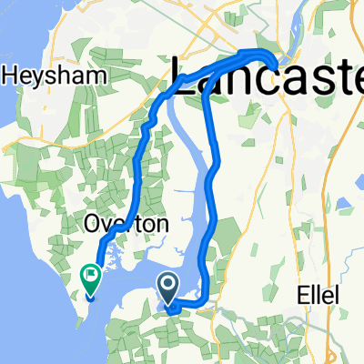
Day 8, 37 hilly miles from Lancaster to Tockholes
Trasa rowerowa rozpoczynająca się w Galgate, Anglia, Zjednoczone Królestwo Wielkiej Brytanii.
Przegląd
O tej trasie
September 8, 2008. Today we started a half hour earlier than normal (8:00 instead of 8:30). It was a glorious day and we had not realized how pastorally "green and pleasant" is northern Lancashire just a few miles from the (former) dark satanic mills of Preston, Blackburn, Manchester, Liverpool and the dozens of factory towns in between. We turned east off the A6 at Galgate and took back roads through Oakenclough, Inglewhite, and Longridge (where we had coffee at a stylish cafe-wine bar internally integrated, we discovered on entering, with a hair salon. This was actually a short day of cycling - 37 miles in linear distance but about 4,000 feet in accumulated vertical assent. Half way to Blackburn we celebrated our "Everest moment" when the trip accumulated assent reached 29,028 feet. We began to wonder whether the line from the Beatles song was actually "there are 4,000 hills in Blackburn, Lancashire" but we eventually emerged into the rural road to Tockholes, where Charles I hid in a tree from Cromwell's army. Our cycling day ended with a relaxed late lunch at the canine-filled Royal Arms. Our hotel was The Lion, an old and quite large hotel on the High Street, of Shrewsbury.
- -:--
- Czas
- 58,4 km
- Dystans
- 660 m
- Przewyższenia
- 458 m
- Spadek
- ---
- Śr. Prędkość
- 258 m
- Maks. wysokość

Zdjęcia trasy


Jakość trasy
Typy dróg i nawierzchnie na trasie
Typy dróg
Droga
24,9 km
(43 %)
Ruchliwa droga
20,7 km
(35 %)
Powierzchnie
Utwardzona
18,5 km
(32 %)
Asfalt
17,2 km
(30 %)
Nawierzchnia (nieokreślona)
1,2 km
(2 %)
Niezdefiniowany
40 km
(68 %)
Kontynuuj z Bikemap
Użyj, edytuj lub pobierz tę trasę rowerową
Chcesz przejechać trasę Day 8, 37 hilly miles from Lancaster to Tockholes lub dostosować ją do swojej wycieczki? Oto, co możesz zrobić z tą trasą na Bikemap:
Darmowe funkcje
- Zapisz tę trasę jako ulubioną lub w kolekcji
- Skopiuj i zaplanuj swoją wersję tej trasy
- Synchronizuj swoją trasę z Garminem lub Wahoo
Funkcje Premium
3 dni bezpłatnej wersji próbnej lub jednorazowa opłata. Dowiedz się więcej o Bikemap Premium.
- Nawiguj po tej trasie na iOS i Androidzie
- Eksportuj plik GPX / KML tej trasy
- Stwórz swój własny wydruk (wypróbuj za darmo)
- Pobierz tę trasę do nawigacji offline
Odkryj więcej funkcji Premium.
Uzyskaj Bikemap PremiumOd naszej społeczności
Galgate: Inne popularne trasy rozpoczynające się tutaj
 Day 8 - Lancaster to Broughton-in-Furness
- Dystans
- 110,9 km
- Przewyższenia
- 1005 m
- Spadek
- 1051 m
- Lokalizacja
- Galgate, Anglia, Zjednoczone Królestwo Wielkiej Brytanii
 Day 8, 37 hilly miles from Lancaster to Tockholes
- Dystans
- 58,4 km
- Przewyższenia
- 660 m
- Spadek
- 458 m
- Lokalizacja
- Galgate, Anglia, Zjednoczone Królestwo Wielkiej Brytanii
 Fast ride in Lancaster
- Dystans
- 27,7 km
- Przewyższenia
- 68 m
- Spadek
- 66 m
- Lokalizacja
- Galgate, Anglia, Zjednoczone Królestwo Wielkiej Brytanii
 Glasson Dock to Grasmere
- Dystans
- 83,6 km
- Przewyższenia
- 463 m
- Spadek
- 397 m
- Lokalizacja
- Galgate, Anglia, Zjednoczone Królestwo Wielkiej Brytanii
 Glasson Marina to Sunderland Point
- Dystans
- 19,6 km
- Przewyższenia
- 67 m
- Spadek
- 65 m
- Lokalizacja
- Galgate, Anglia, Zjednoczone Królestwo Wielkiej Brytanii
 38m Ride home via Silverdale and Arnside
- Dystans
- 61,8 km
- Przewyższenia
- 562 m
- Spadek
- 547 m
- Lokalizacja
- Galgate, Anglia, Zjednoczone Królestwo Wielkiej Brytanii
 Glasson Dock to Grasmere
- Dystans
- 83,6 km
- Przewyższenia
- 465 m
- Spadek
- 400 m
- Lokalizacja
- Galgate, Anglia, Zjednoczone Królestwo Wielkiej Brytanii
 bowland off orad evening/weekend-henry
- Dystans
- 27,6 km
- Przewyższenia
- 708 m
- Spadek
- 713 m
- Lokalizacja
- Galgate, Anglia, Zjednoczone Królestwo Wielkiej Brytanii
Otwórz ją w aplikacji