Matosinhos, 77, Leça - Nocturno em BTT
- 27,4 km
- 301 m
- 312 m
- Matosinhos, Distrito do Porto, Portugalia
Trasa rowerowa rozpoczynająca się w Matosinhos, Distrito do Porto, Portugalia.
Przegląd
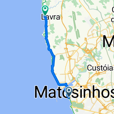
Wyścig zaczyna się i kończy na zatłoczonej plaży w Matosinhos, w pobliżu niektórych z najbardziej znanych konserwacji rybnych w regionie, i kieruje się na północ w stronę Vila do Conde.
Około 30 km nadmorskich dróg, które będą dobrą okazją do utworzenia BA, ponieważ atlantyckie wiatry wieją bezpośrednio w twarze zawodników.
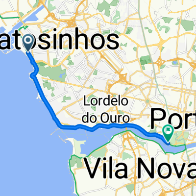
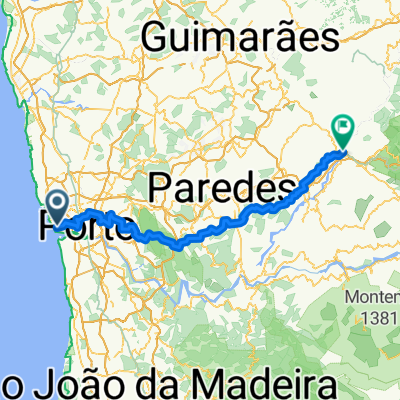
Po dotarciu do Vila do Conde, kolarze skręcają w stronę lądu w kierunku Trofy. Stamtąd zaczynają wyścig w kierunku południowym, mijając mały Monte Santo Oviedo, Maitę, Ermesinde, Rio Tinto i w dół do Gondomar w pobliżu rzeki Douro. To będzie najbardziej wyboista część trasy, ale nachylenia są tak małe, a do pokonania pozostało jeszcze 30 km, że puncheurs będzie trudno zaskoczyć.
Wyścig przechodzi teraz w swoją ostatnią część. Aby uniknąć zatłoczonego centrum Porto, kolarze przekraczają São Mamede de Infesta, Leça do Balio, Santa Cruz do Bispo i Guifões. Będąc przedmieściami dużego miasta, drogi nie są szerokie ani nie mają łatwych zakrętów, więc pozycjonowanie będzie bardzo trudne.
Po Guifões, na ostatnich 7 km kolarze wracają do Matosinhos. Organizatorzy zrobili wszystko, co w ich mocy, aby przejechać obok wszystkich głównych punktów orientacyjnych w mieście (głównie konserwacji rybnych) i tym samym skomplikowali ostatnią część. W ostatnich 3 km mamy 11 zakrętów o 90° i 1 rondo. Ostatni z tych zakrętów znajduje się zaledwie 200 metrów od linii mety... ehm, przepraszam, od linii finiszu.
Pozycjonowanie i dobra technika będą kluczowe, aby wygrać wyścig.
utworzono 3 lata temu temu
Jakość trasy
Spokojna droga
46 km
(37 %)
Droga
27,4 km
(22 %)
Utwardzona
59,7 km
(48 %)
Nieutwardzona
1,2 km
(1 %)
Asfalt
56 km
(45 %)
Nawierzchnia (nieokreślona)
1,2 km
(1 %)
Kontynuuj z Bikemap
Chcesz przejechać trasę Taça Conservas de Matosinhos lub dostosować ją do swojej wycieczki? Oto, co możesz zrobić z tą trasą na Bikemap:
3 dni bezpłatnej wersji próbnej lub jednorazowa opłata. Dowiedz się więcej o Bikemap Premium.
Odkryj więcej funkcji Premium.
Uzyskaj Bikemap PremiumOd naszej społeczności
Otwórz ją w aplikacji