

Carpathian peaks. Route 3. Rokyta-Makovytsia.
Trasa rowerowa rozpoczynająca się w Yaremche, Obwód iwanofrankiwski, Ukraina.
Przegląd
O tej trasie
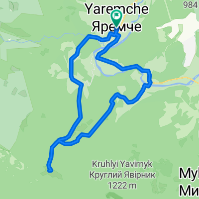
Trasa zaczyna się przy moście nad rzeką Prutets, która zachwyca swoim pięknem. Wzdłuż kanionu rzeki kierujemy się do skał Kostel, a następnie wspinamy się na górę Rokyta. Na szczycie robimy fantastyczne zdjęcia, a następnie przez górskie łąki kierujemy się na górę Makovytsia, potem schodzimy do Jamnej i wracamy do miejsca naszego zakwaterowania.
- -:--
- Czas
- 34,6 km
- Dystans
- 802 m
- Przewyższenia
- 804 m
- Spadek
- ---
- Śr. Prędkość
- ---
- Maks. wysokość

Kontynuuj z Bikemap
Użyj, edytuj lub pobierz tę trasę rowerową
Chcesz przejechać trasę Carpathian peaks. Route 3. Rokyta-Makovytsia. lub dostosować ją do swojej wycieczki? Oto, co możesz zrobić z tą trasą na Bikemap:
Darmowe funkcje
- Zapisz tę trasę jako ulubioną lub w kolekcji
- Skopiuj i zaplanuj swoją wersję tej trasy
- Synchronizuj swoją trasę z Garminem lub Wahoo
Funkcje Premium
3 dni bezpłatnej wersji próbnej lub jednorazowa opłata. Dowiedz się więcej o Bikemap Premium.
- Nawiguj po tej trasie na iOS i Androidzie
- Eksportuj plik GPX / KML tej trasy
- Stwórz swój własny wydruk (wypróbuj za darmo)
- Pobierz tę trasę do nawigacji offline
Odkryj więcej funkcji Premium.
Uzyskaj Bikemap PremiumOd naszej społeczności
Yaremche: Inne popularne trasy rozpoczynające się tutaj
 Маршрут 302 - Маливо
- Dystans
- 26,5 km
- Przewyższenia
- 514 m
- Spadek
- 518 m
- Lokalizacja
- Yaremche, Obwód iwanofrankiwski, Ukraina
 Яремче-Явірник
- Dystans
- 17,6 km
- Przewyższenia
- 699 m
- Spadek
- 700 m
- Lokalizacja
- Yaremche, Obwód iwanofrankiwski, Ukraina
 2012-07-28 Дора-Синячка-Фр 80км
- Dystans
- 79,2 km
- Przewyższenia
- 950 m
- Spadek
- 1169 m
- Lokalizacja
- Yaremche, Obwód iwanofrankiwski, Ukraina
 Полонина Явірник
- Dystans
- 14,1 km
- Przewyższenia
- 787 m
- Spadek
- 787 m
- Lokalizacja
- Yaremche, Obwód iwanofrankiwski, Ukraina
 Дора-Яремче
- Dystans
- 40,3 km
- Przewyższenia
- 1375 m
- Spadek
- 1343 m
- Lokalizacja
- Yaremche, Obwód iwanofrankiwski, Ukraina
 Яремче - г.Синячка - Надвірна
- Dystans
- 39,4 km
- Przewyższenia
- 950 m
- Spadek
- 1035 m
- Lokalizacja
- Yaremche, Obwód iwanofrankiwski, Ukraina
 Маршрут 304 - Оглядовий
- Dystans
- 6,2 km
- Przewyższenia
- 164 m
- Spadek
- 163 m
- Lokalizacja
- Yaremche, Obwód iwanofrankiwski, Ukraina
 Маршрут 301 - Білий камінь
- Dystans
- 16 km
- Przewyższenia
- 531 m
- Spadek
- 528 m
- Lokalizacja
- Yaremche, Obwód iwanofrankiwski, Ukraina
Otwórz ją w aplikacji