

LEJO'G 20 Oban to Fort William
Trasa rowerowa rozpoczynająca się w Oban, Szkocja, Zjednoczone Królestwo Wielkiej Brytanii.
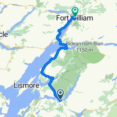
Przegląd
O tej trasie
61 km do promu Corran + 17 km do Camusnagaul.
Ostatni prom o 16:35 (lub +25 km dookoła jeziora). Zależy od pogody i pływów.
O 10 km krócej, podążając A82 po wschodniej stronie (bez promów).
- -:--
- Czas
- 81,1 km
- Dystans
- 788 m
- Przewyższenia
- 808 m
- Spadek
- ---
- Śr. Prędkość
- 113 m
- Maks. wysokość

Jakość trasy
Typy dróg i nawierzchnie na trasie
Typy dróg
Droga rowerowa
43 km
(53 %)
Spokojna droga
8,1 km
(10 %)
Powierzchnie
Utwardzona
60,9 km
(75 %)
Asfalt
46,3 km
(57 %)
Nawierzchnia (nieokreślona)
14,6 km
(18 %)
Niezdefiniowany
20,3 km
(25 %)
Najważniejsze punkty trasy
Punkty zainteresowania na trasie
Nocleg po 0 km
Ardmor Seaview
Interesujące miejsce po 53,9 km
Last Clansman Memorial On this rocky knoll above the loch an innocent man was hanged for a famous crime. Known as the Appin Murder, it intrigued Robert Louis Stevenson and inspired him to write Kidnapped. Known as Red Fox, Colin Campbell of Glenure had, following the defeat at Culloden, been appointed factor of the forfeited estates of the Appin Stewarts. On the morning of 14 May 1752, he had crossed the narrows at Ballachulish by ferry. With Campbell were a man servant, a sheriff officer, and an Edinburgh lawyer. When they reached the woods at Lettermore, a shot rang out. Hit in the back, perhaps through the heart, Campbell fell to the ground fatally wounded. Despite being able to convincingly show he had been nowhere near the woods that day, James Stewart's alibi was dismissed. On the 8th November 1752, on this knoll known as Cnoc Chaolais Mhic Phadraig, James Stewart was hung and his body left to hang there for eighteen months, a blunt warning against sedition and armed rebellion that no traveller across the narrows at Ballachulish would miss.
Woda pitna po 54,1 km
Loch Leven Hotel
Interesujące miejsce po 54,1 km
F.W.Holroyd Art Gallery
Interesujące miejsce po 60,9 km
Corran to Ardgour Ferry 0630 - 0850 every 20 min 0915 - 2045 every 30 min * 10km shorter following A82 along east side - no ferries.
Woda pitna po 61,5 km
Nomad Cafe closes 1500
Woda pitna po 61,6 km
The Inn at Ardgour
Woda pitna po 62,6 km
Ardgour Ales Brewery ref Miriam Margolyes
Interesujące miejsce po 67,2 km
Watercolour Music Recording studio ref Miriam Margolyes....
Interesujące miejsce po 67,3 km
Viewpoint
Interesujące miejsce po 67,3 km
Glenfinnan Viewpoint
Interesujące miejsce po 67,3 km
Glenfinnan Viaduct Train crosses 1045 & 1500
Interesujące miejsce po 78,5 km
Camousnagaul Ferry 0815 1015 1230 1635 ₤3.30 no service Sundays weather and tides permitting
Interesujące miejsce po 80,4 km
Fort William Pier Promenade
Interesujące miejsce po 80,6 km
The Old Fort of Fort William
Interesujące miejsce po 80,8 km
West Coast Railways Jacobite Steam Train - Hogwarts Express Train Dep 1015 & 1250 Arr 1603 & 1852
Interesujące miejsce po 81 km
Train photo opportunity Incoming 1555 & 1845 Outgoing 1015 & 1250
Interesujące miejsce po 81 km
Fort William Shinty Club
Interesujące miejsce po 81,1 km
Ben Nevis
Interesujące miejsce po 81,1 km
Ben Nevis Distillery
Interesujące miejsce po 81,1 km
Old Inverlochy Castle Ruined 13th-century castle on the banks of River Lochy, that was backdrop for Inverlochy battles.
Interesujące miejsce po 81,1 km
Cow Hill Viewpoint
Nocleg po 81,1 km
MacLean Guest House
Kontynuuj z Bikemap
Użyj, edytuj lub pobierz tę trasę rowerową
Chcesz przejechać trasę LEJO'G 20 Oban to Fort William lub dostosować ją do swojej wycieczki? Oto, co możesz zrobić z tą trasą na Bikemap:
Darmowe funkcje
- Zapisz tę trasę jako ulubioną lub w kolekcji
- Skopiuj i zaplanuj swoją wersję tej trasy
- Podziel trasę na etapy, aby utworzyć kilkudniową wycieczkę
- Synchronizuj swoją trasę z Garminem lub Wahoo
Funkcje Premium
3 dni bezpłatnej wersji próbnej lub jednorazowa opłata. Dowiedz się więcej o Bikemap Premium.
- Nawiguj po tej trasie na iOS i Androidzie
- Eksportuj plik GPX / KML tej trasy
- Stwórz swój własny wydruk (wypróbuj za darmo)
- Pobierz tę trasę do nawigacji offline
Odkryj więcej funkcji Premium.
Uzyskaj Bikemap PremiumOd naszej społeczności
Oban: Inne popularne trasy rozpoczynające się tutaj
 Schottland 2012
- Dystans
- 602,3 km
- Przewyższenia
- 1406 m
- Spadek
- 1397 m
- Lokalizacja
- Oban, Szkocja, Zjednoczone Królestwo Wielkiej Brytanii
 St Columba's Way - Taynuilt to Dalmally St Columba's way-Taynuilt to Dalmally
- Dystans
- 34,2 km
- Przewyższenia
- 728 m
- Spadek
- 706 m
- Lokalizacja
- Oban, Szkocja, Zjednoczone Królestwo Wielkiej Brytanii
 Scotland 2020 Day 08
- Dystans
- 53,4 km
- Przewyższenia
- 199 m
- Spadek
- 200 m
- Lokalizacja
- Oban, Szkocja, Zjednoczone Królestwo Wielkiej Brytanii
 oban fort william
- Dystans
- 77,4 km
- Przewyższenia
- 264 m
- Spadek
- 270 m
- Lokalizacja
- Oban, Szkocja, Zjednoczone Królestwo Wielkiej Brytanii
 Oban 109km route
- Dystans
- 109,2 km
- Przewyższenia
- 896 m
- Spadek
- 902 m
- Lokalizacja
- Oban, Szkocja, Zjednoczone Królestwo Wielkiej Brytanii
 Bonawe to Fort William
- Dystans
- 70 km
- Przewyższenia
- 406 m
- Spadek
- 412 m
- Lokalizacja
- Oban, Szkocja, Zjednoczone Królestwo Wielkiej Brytanii
 JOGLE Day 4
- Dystans
- 126,4 km
- Przewyższenia
- 907 m
- Spadek
- 906 m
- Lokalizacja
- Oban, Szkocja, Zjednoczone Królestwo Wielkiej Brytanii
 Oban Fort William
- Dystans
- 80,7 km
- Przewyższenia
- 285 m
- Spadek
- 286 m
- Lokalizacja
- Oban, Szkocja, Zjednoczone Królestwo Wielkiej Brytanii
Otwórz ją w aplikacji