

CYCLING THE RHINE: Route 16A
Trasa rowerowa rozpoczynająca się w Ludwigshafen, Nadrenia-Palatynat, Niemcy.
Przegląd
O tej trasie
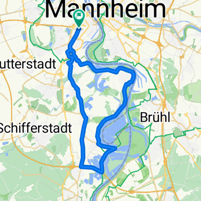
Dworzec kolejowy Mannheim do dworca kolejowego Worth am Rhein (Mitte), wzdłuż rzeki Ren.
- -:--
- Czas
- 79 km
- Dystans
- 119 m
- Przewyższenia
- 112 m
- Spadek
- ---
- Śr. Prędkość
- ---
- Maks. wysokość
Jakość trasy
Typy dróg i nawierzchnie na trasie
Typy dróg
Droga leśna
45,8 km
(58 %)
Ścieżka
9,5 km
(12 %)
Powierzchnie
Utwardzona
67,1 km
(85 %)
Nieutwardzona
3,2 km
(4 %)
Asfalt
66,3 km
(84 %)
Żwir
1,6 km
(2 %)
Najważniejsze punkty trasy
Punkty zainteresowania na trasie
Interesujące miejsce po 0,9 km
At this point, the previous described route (Route 15A) deviated from the Rhine Route to terminate at Mannheim railway station.
Interesujące miejsce po 1 km
At this point, the continuation along the Rhine Route, from Route 15A, joins this route (Route 16A) to continue along the Rhine Route.
Interesujące miejsce po 9,8 km
Altrip - Neckarau Ferry. 05h00 - 22h30, every 15 minutes.
Interesujące miejsce po 11,2 km
[KM 414]
Interesujące miejsce po 14,1 km
[KM 411]
Interesujące miejsce po 14,4 km
[KM 410]
Interesujące miejsce po 14,8 km
[KM 409]
Interesujące miejsce po 15,2 km
[KM 408]
Interesujące miejsce po 20,7 km
[KM 407]
Nocleg po 27 km
DJH Speyer (Youth Hostel) 5 Geibstrasse
Interesujące miejsce po 40 km
From this point, you can cycle straight onwards, instead of turning towards the river. You will re-join the described route 2.3 km further along this road, where it turns hard Right, away from the Rhine.
Interesujące miejsce po 42,3 km
If you elected to remain on the inland route, you will re-join the described (Rhine-side) route at this point.
Kontynuuj z Bikemap
Użyj, edytuj lub pobierz tę trasę rowerową
Chcesz przejechać trasę CYCLING THE RHINE: Route 16A lub dostosować ją do swojej wycieczki? Oto, co możesz zrobić z tą trasą na Bikemap:
Darmowe funkcje
- Zapisz tę trasę jako ulubioną lub w kolekcji
- Skopiuj i zaplanuj swoją wersję tej trasy
- Synchronizuj swoją trasę z Garminem lub Wahoo
Funkcje Premium
3 dni bezpłatnej wersji próbnej lub jednorazowa opłata. Dowiedz się więcej o Bikemap Premium.
- Nawiguj po tej trasie na iOS i Androidzie
- Eksportuj plik GPX / KML tej trasy
- Stwórz swój własny wydruk (wypróbuj za darmo)
- Pobierz tę trasę do nawigacji offline
Odkryj więcej funkcji Premium.
Uzyskaj Bikemap PremiumOd naszej społeczności
Ludwigshafen: Inne popularne trasy rozpoczynające się tutaj
 CYCLING THE RHINE: Route 16A
- Dystans
- 79 km
- Przewyższenia
- 119 m
- Spadek
- 112 m
- Lokalizacja
- Ludwigshafen, Nadrenia-Palatynat, Niemcy
 LU-Kalmit-LU
- Dystans
- 97,5 km
- Przewyższenia
- 688 m
- Spadek
- 694 m
- Lokalizacja
- Ludwigshafen, Nadrenia-Palatynat, Niemcy
 Von Mannheim nach Eberbach
- Dystans
- 56,5 km
- Przewyższenia
- 211 m
- Spadek
- 175 m
- Lokalizacja
- Ludwigshafen, Nadrenia-Palatynat, Niemcy
 ADFC Mannheim So,12.07.2009
- Dystans
- 87,7 km
- Przewyższenia
- 326 m
- Spadek
- 323 m
- Lokalizacja
- Ludwigshafen, Nadrenia-Palatynat, Niemcy
 BASF Radtour 2011
- Dystans
- 159,1 km
- Przewyższenia
- 667 m
- Spadek
- 668 m
- Lokalizacja
- Ludwigshafen, Nadrenia-Palatynat, Niemcy
 MA - Speyer
- Dystans
- 55,5 km
- Przewyższenia
- 71 m
- Spadek
- 71 m
- Lokalizacja
- Ludwigshafen, Nadrenia-Palatynat, Niemcy
 Ludwigshafener Trainingsrunde
- Dystans
- 41,2 km
- Przewyższenia
- 63 m
- Spadek
- 64 m
- Lokalizacja
- Ludwigshafen, Nadrenia-Palatynat, Niemcy
 43_Ludwigshafen – Friedelsheim – Bad Dürkheim
- Dystans
- 24,7 km
- Przewyższenia
- 62 m
- Spadek
- 18 m
- Lokalizacja
- Ludwigshafen, Nadrenia-Palatynat, Niemcy
Otwórz ją w aplikacji