
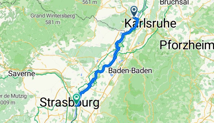
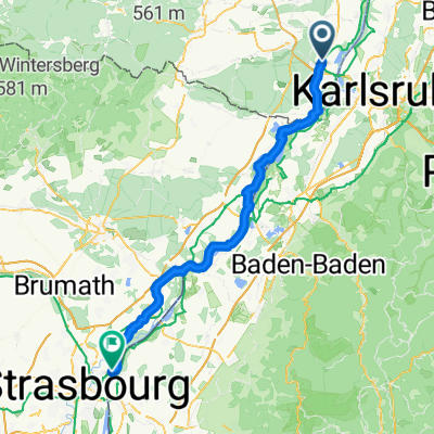
CYCLING THE RHINE: Route 17A
Trasa rowerowa rozpoczynająca się w Wörth am Rhein, Nadrenia-Palatynat, Niemcy.
Przegląd
O tej trasie
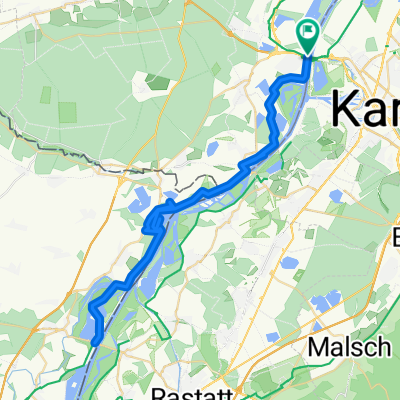
Dworzec kolejowy Wörth am Rhein (Mitte) do dworca kolejowego w Kehl, wzdłuż rzeki Ren.\n\nUWAGA: Układ dróg między Wörth am Rhein, przez Maximiliansau do Renu, znacznie się zmienił i opisana trasa (w wersji papierowej) już nie obowiązuje. Ta mapa pokazuje zaktualizowaną trasę w tym obszarze.\n\nNiektóre zmiany korzystają z nowszych tras rowerowych bliżej Renu.
- -:--
- Czas
- 82 km
- Dystans
- 75 m
- Przewyższenia
- 41 m
- Spadek
- ---
- Śr. Prędkość
- ---
- Maks. wysokość
Jakość trasy
Typy dróg i nawierzchnie na trasie
Typy dróg
Droga leśna
56,6 km
(69 %)
Droga dojazdowa
5,7 km
(7 %)
Powierzchnie
Utwardzona
33,6 km
(41 %)
Nieutwardzona
42,6 km
(52 %)
Asfalt
32 km
(39 %)
Żwir
23 km
(28 %)
Najważniejsze punkty trasy
Punkty zainteresowania na trasie
Nocleg po 5,2 km
Friends of Nature site. Rheinfrieden
Interesujące miejsce po 13,1 km
Border between France and Germany.
Nocleg po 29,4 km
Guest House Anker. I have stayed here and found the service and facilities to be excellent.
Interesujące miejsce po 65,6 km
Deviation from the described route (in the hard copy book) at this point, to take advantage of the riverside route.
Interesujące miejsce po 80,6 km
Deviation from described route (in the hard copy book) at this point, to simplify the route. Rejoin described route at corner of Konigsberger and Elbinger Strassen.
Nocleg po 82 km
YOUTH HOSTEL: DJH Kehl. Altrhrheinweg 11, Kehl I have stayed at this hostel a number of times. I can recommend the facilities and cuisine.
Nocleg po 82 km
YOUTH HOSTEL: FUAJ Strasbourg, Parc du Rhin. I have stayed at this hostel. I would not stay here again.
Kontynuuj z Bikemap
Użyj, edytuj lub pobierz tę trasę rowerową
Chcesz przejechać trasę CYCLING THE RHINE: Route 17A lub dostosować ją do swojej wycieczki? Oto, co możesz zrobić z tą trasą na Bikemap:
Darmowe funkcje
- Zapisz tę trasę jako ulubioną lub w kolekcji
- Skopiuj i zaplanuj swoją wersję tej trasy
- Podziel trasę na etapy, aby utworzyć kilkudniową wycieczkę
- Synchronizuj swoją trasę z Garminem lub Wahoo
Funkcje Premium
3 dni bezpłatnej wersji próbnej lub jednorazowa opłata. Dowiedz się więcej o Bikemap Premium.
- Nawiguj po tej trasie na iOS i Androidzie
- Eksportuj plik GPX / KML tej trasy
- Stwórz swój własny wydruk (wypróbuj za darmo)
- Pobierz tę trasę do nawigacji offline
Odkryj więcej funkcji Premium.
Uzyskaj Bikemap PremiumOd naszej społeczności
Wörth am Rhein: Inne popularne trasy rozpoczynające się tutaj
 Elsassrunde
- Dystans
- 60,2 km
- Przewyższenia
- 176 m
- Spadek
- 187 m
- Lokalizacja
- Wörth am Rhein, Nadrenia-Palatynat, Niemcy
 Wörth am Rhein - Kehl
- Dystans
- 77,1 km
- Przewyższenia
- 206 m
- Spadek
- 168 m
- Lokalizacja
- Wörth am Rhein, Nadrenia-Palatynat, Niemcy
 CYCLING THE RHINE: Route 17A
- Dystans
- 82 km
- Przewyższenia
- 75 m
- Spadek
- 41 m
- Lokalizacja
- Wörth am Rhein, Nadrenia-Palatynat, Niemcy
 Deutsch-Französische Maifahrt 2010 - RTF des RSC Wörth 1980 e.V. - 164 km Strecke
- Dystans
- 150 km
- Przewyższenia
- 650 m
- Spadek
- 650 m
- Lokalizacja
- Wörth am Rhein, Nadrenia-Palatynat, Niemcy
 44_Wörth – Lauterbourg (F) – Wörth
- Dystans
- 37,6 km
- Przewyższenia
- 71 m
- Spadek
- 71 m
- Lokalizacja
- Wörth am Rhein, Nadrenia-Palatynat, Niemcy
 Wörth am Rhein - Worms
- Dystans
- 113,2 km
- Przewyższenia
- 0 m
- Spadek
- 15 m
- Lokalizacja
- Wörth am Rhein, Nadrenia-Palatynat, Niemcy
 Maximiliansau
- Dystans
- 58,1 km
- Przewyższenia
- 186 m
- Spadek
- 240 m
- Lokalizacja
- Wörth am Rhein, Nadrenia-Palatynat, Niemcy
 Eisenbahnstraße, Wörth am Rhein nach Route du Rhin, Gambsheim
- Dystans
- 62,9 km
- Przewyższenia
- 140 m
- Spadek
- 114 m
- Lokalizacja
- Wörth am Rhein, Nadrenia-Palatynat, Niemcy
Otwórz ją w aplikacji