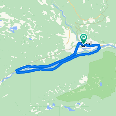

Von Gol bis Oslo
- 643 km
- 13 198 m
- 13 393 m
- Gol, Buskerud fylke, Norwegia
Trasa rowerowa rozpoczynająca się w Gol, Buskerud fylke, Norwegia.
Przegląd
<span style="color: #000000; font-family: verdana, arial, helvetica, sans-serif; font-size: 11px; line-height: 16px; -webkit-border-horizontal-spacing: 4px; -webkit-border-vertical-spacing: 4px;">This route starts off at the intersection/crossroads at Fjellheimskrysset on highway Rv 51 (Gol - Leira).<br style="font: normal normal normal 11px/1.5em verdana, arial, helvetica, sans-serif; color: #000000; line-height: 0.8em;" /><br style="font: normal normal normal 11px/1.5em verdana, arial, helvetica, sans-serif; color: #000000; line-height: 0.8em;" />Follow the Golsfjellveien past the crossroads to Kamben, Ørterstølen and further on to Oset Høyfjellshotell. Continue towards the Tislei dam, cross it, and follow the road up to the crossroads at Buastølen.<br style="font: normal normal normal 11px/1.5em verdana, arial, helvetica, sans-serif; color: #000000; line-height: 0.8em;" /><br style="font: normal normal normal 11px/1.5em verdana, arial, helvetica, sans-serif; color: #000000; line-height: 0.8em;" /> Keep going straight past the different summer farmsuntil you get to Gomobu, which is the first obligatory waffle stop on the route. <br style="font: normal normal normal 11px/1.5em verdana, arial, helvetica, sans-serif; color: #000000; line-height: 0.8em;" /><br style="font: normal normal normal 11px/1.5em verdana, arial, helvetica, sans-serif; color: #000000; line-height: 0.8em;" />From Gomobu the road is steep downhill until you get on to the Panoramavegen (Panorama road) between Hemsedal and Valdres. <br style="font: normal normal normal 11px/1.5em verdana, arial, helvetica, sans-serif; color: #000000; line-height: 0.8em;" /><br style="font: normal normal normal 11px/1.5em verdana, arial, helvetica, sans-serif; color: #000000; line-height: 0.8em;" />On the Panoramavegen you can choose if you want the shorter route by turning left and going straight to Nøsen, where they make great waffles too, or if you want to go right and follow the signs to Trollhovd.<br style="font: normal normal normal 11px/1.5em verdana, arial, helvetica, sans-serif; color: #000000; line-height: 0.8em;" /><br style="font: normal normal normal 11px/1.5em verdana, arial, helvetica, sans-serif; color: #000000; line-height: 0.8em;" />From Trollhovd the route is downhill past Grønsetnabben og Svenskefjorden. Go straight ahead (do not cross the bridge on the right!) and follow the road along the lake and back to Panoramavegen. <br style="font: normal normal normal 11px/1.5em verdana, arial, helvetica, sans-serif; color: #000000; line-height: 0.8em;" /><br style="font: normal normal normal 11px/1.5em verdana, arial, helvetica, sans-serif; color: #000000; line-height: 0.8em;" />Go right and stay on the main road past the Flyvass dam and further along the Tisleifjorden. Go on past Langestølen (shop) and back to Buasttølen. Go left, ride back to Oset and onwards to Fjellheimkrysset.</span>
utworzono 14 lat temu temu
Jakość trasy
Droga
24 km
47 %
Spokojna droga
23,5 km
46 %
Nieutwardzona
30,1 km
(59 %)
Żwir
30,1 km
59 %
Niezdefiniowany
20,9 km
41 %
Kontynuuj z Bikemap
Chcesz przejechać trasę The Waffle Tour 2 CLONED FROM ROUTE 496988 lub dostosować ją do swojej wycieczki? Oto, co możesz zrobić z tą trasą na Bikemap:
3 dni bezpłatnej wersji próbnej lub jednorazowa opłata. Dowiedz się więcej o Bikemap Premium.
Odkryj więcej funkcji Premium.
Uzyskaj Bikemap PremiumOd naszej społeczności
Otwórz ją w aplikacji