SKG lang 8: Traunreut-Grafing; 67,5km 690hm
Trasa rowerowa rozpoczynająca się w Traunreut, Bawaria, Niemcy.
Przegląd
O tej trasie
St.Georgen - Irrsing - Haßmonig - (KLT) - Truchtlaching - (MOZ) - Seeon - (KW) - Oberbrunn - Wimm - Hinzing - Höswang - (BzB) - Almertsham - Siegsdorf - Halfing - Gunzenham - Schonstett - Moosham - Raming - (WRR) - Griesstätt - Katzbach - Mitterhof - Lehen - Potzmühle - Fassrain - Filzen - - Lohen - Sensau - Traxl - Grafing
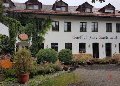
Kastenwirt, Grafing, Lederergasse
- -:--
- Czas
- 67,5 km
- Dystans
- 795 m
- Przewyższenia
- 806 m
- Spadek
- ---
- Śr. Prędkość
- 592 m
- Maks. wysokość
Jakość trasy
Typy dróg i nawierzchnie na trasie
Typy dróg
Spokojna droga
38,5 km
(57 %)
Droga
14,9 km
(22 %)
Powierzchnie
Utwardzona
50 km
(74 %)
Nieutwardzona
10,1 km
(15 %)
Asfalt
49,3 km
(73 %)
Żwir
6,8 km
(10 %)
Najważniejsze punkty trasy
Punkty zainteresowania na trasie

Interesujące miejsce po 6,4 km
Kirche Truchtlaching

Interesujące miejsce po 9,3 km
Brauerei CAMBA

Interesujące miejsce po 11,4 km
Blick auf Klosterseeon

Interesujące miejsce po 11,9 km
Skulpturengarten mit Nackedeis...

Interesujące miejsce po 14,6 km
Schloss Oberbrunn

Interesujące miejsce po 22,8 km
Kirche von Höslwang

Interesujące miejsce po 26,6 km
Kleine Kapelle am Wegesrand

Interesujące miejsce po 27,3 km
Aussichtspunkt mit Bänken und Panoramaschautafel
Interesujące miejsce po 28,9 km
Baden im Halfinger Naturerlebnisweiher

Interesujące miejsce po 36,8 km
Köhlerbad

Interesujące miejsce po 39,6 km
Bank neben Kapelle bei Moosham

Interesujące miejsce po 59,7 km
Schiefer Turm von Sensau

Nocleg po 67,5 km
Kastenwirt, Grafing, Lederergasse
Kontynuuj z Bikemap
Użyj, edytuj lub pobierz tę trasę rowerową
Chcesz przejechać trasę SKG lang 8: Traunreut-Grafing; 67,5km 690hm lub dostosować ją do swojej wycieczki? Oto, co możesz zrobić z tą trasą na Bikemap:
Darmowe funkcje
- Zapisz tę trasę jako ulubioną lub w kolekcji
- Skopiuj i zaplanuj swoją wersję tej trasy
- Synchronizuj swoją trasę z Garminem lub Wahoo
Funkcje Premium
3 dni bezpłatnej wersji próbnej lub jednorazowa opłata. Dowiedz się więcej o Bikemap Premium.
- Nawiguj po tej trasie na iOS i Androidzie
- Eksportuj plik GPX / KML tej trasy
- Stwórz swój własny wydruk (wypróbuj za darmo)
- Pobierz tę trasę do nawigacji offline
Odkryj więcej funkcji Premium.
Uzyskaj Bikemap PremiumOd naszej społeczności
Traunreut: Inne popularne trasy rozpoczynające się tutaj
 sonntags Route Chieming
- Dystans
- 40,5 km
- Przewyższenia
- 317 m
- Spadek
- 314 m
- Lokalizacja
- Traunreut, Bawaria, Niemcy
 Von Traunreut zum Chiemsee
- Dystans
- 11,4 km
- Przewyższenia
- 99 m
- Spadek
- 123 m
- Lokalizacja
- Traunreut, Bawaria, Niemcy
 Traunreut-Tettenhausen-Fridolfing-Tegling-Trt.
- Dystans
- 41,7 km
- Przewyższenia
- 330 m
- Spadek
- 330 m
- Lokalizacja
- Traunreut, Bawaria, Niemcy
 Chiemsee Runde.
- Dystans
- 74,7 km
- Przewyższenia
- 207 m
- Spadek
- 208 m
- Lokalizacja
- Traunreut, Bawaria, Niemcy
 Chiemgauer Seehund
- Dystans
- 156,7 km
- Przewyższenia
- 1882 m
- Spadek
- 1847 m
- Lokalizacja
- Traunreut, Bawaria, Niemcy
 Urlaub2022_7_Chiemsee -Salzburg
- Dystans
- 57,6 km
- Przewyższenia
- 432 m
- Spadek
- 571 m
- Lokalizacja
- Traunreut, Bawaria, Niemcy
 Traunreut Radlroute 1
- Dystans
- 10,1 km
- Przewyższenia
- 73 m
- Spadek
- 75 m
- Lokalizacja
- Traunreut, Bawaria, Niemcy
 SKG lang 8: Traunreut-Grafing; 67,5km 690hm
- Dystans
- 67,5 km
- Przewyższenia
- 795 m
- Spadek
- 806 m
- Lokalizacja
- Traunreut, Bawaria, Niemcy
Otwórz ją w aplikacji


