
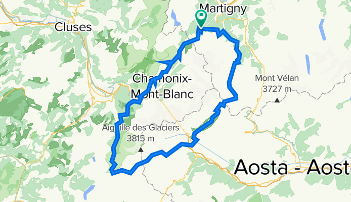
Hiking 120 Miles Alone on the Tour Du Mont Blanc Loop
Trasa rowerowa rozpoczynająca się w Martigny-Combe, Valais, Szwajcaria.
Przegląd
O tej trasie
Tour du Mont Blanc to pętla o długości 120 mil, która okrąża masyw Mont Blanc i przebiega przez Alpy szwajcarskie, francuskie i włoskie. Każdy odcinek w poszczególnych krajach ma własny charakter. Szlak jest dobrze utrzymany i oznaczony kolorowymi markerami 'TMB'. Spotkasz na nim wiele różnych osób, które wędrują z różnych powodów. Zazwyczaj niemożliwe jest określenie, jak długo ktoś już wędruje, ponieważ szlak jest pętlą bez technicznego punktu startu czy mety. Spotkasz wędrowców z dużymi plecakami, którzy pokonują całą pętlę, turystów na jednodniowych wycieczkach, turystów gondolowych, biegaczy górskich, rowerzystów górskich, rodziny z psami oraz miejscowych spacerowiczów. Przechodzisz przez małe wioski ukryte w górach oraz duże, tętniące życiem miasta pełne turystów. Szlak pełen jest schronisk i kempingów, gdzie można jeść, pić i spać. Szlak jest bezpieczny, pełen ludzi chętnych do pomocy w razie potrzeby i dobrze rozwinięty, więc każdy w dobrej kondycji zdrowotnej i idący własnym tempem może pokonać całą pętlę. Polecam Tour du Mont Blanc każdemu, kto próbuje swojej pierwszej wędrówki powyżej 100 mil, ze względu na jego piękno, umiarkowaną trudność i niski poziom ryzyka. Chociaż jest to bardzo popularny i często uczęszczany szlak w Europie, wciąż można odnaleźć chwile spokojnej samotności między miasteczkami i na przełęczach wysokich gór, z dala od dróg czy gondoli.
- -:--
- Czas
- 165,3 km
- Dystans
- 12 832 m
- Przewyższenia
- 12 837 m
- Spadek
- ---
- Śr. Prędkość
- 2663 m
- Maks. wysokość

Kontynuuj z Bikemap
Użyj, edytuj lub pobierz tę trasę rowerową
Chcesz przejechać trasę Hiking 120 Miles Alone on the Tour Du Mont Blanc Loop lub dostosować ją do swojej wycieczki? Oto, co możesz zrobić z tą trasą na Bikemap:
Darmowe funkcje
- Zapisz tę trasę jako ulubioną lub w kolekcji
- Skopiuj i zaplanuj swoją wersję tej trasy
- Podziel trasę na etapy, aby utworzyć kilkudniową wycieczkę
- Synchronizuj swoją trasę z Garminem lub Wahoo
Funkcje Premium
3 dni bezpłatnej wersji próbnej lub jednorazowa opłata. Dowiedz się więcej o Bikemap Premium.
- Nawiguj po tej trasie na iOS i Androidzie
- Eksportuj plik GPX / KML tej trasy
- Stwórz swój własny wydruk (wypróbuj za darmo)
- Pobierz tę trasę do nawigacji offline
Odkryj więcej funkcji Premium.
Uzyskaj Bikemap PremiumOd naszej społeczności
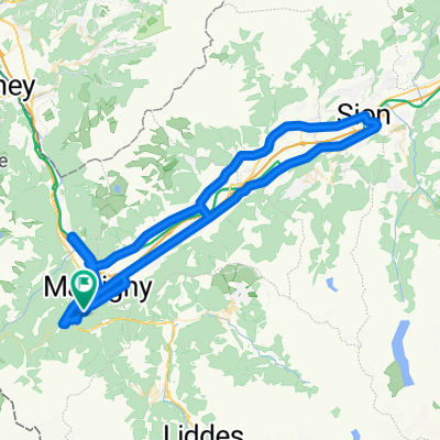
Martigny-Combe: Inne popularne trasy rozpoczynające się tutaj
 MontBlancTour5Tag
- Dystans
- 14 km
- Przewyższenia
- 1107 m
- Spadek
- 935 m
- Lokalizacja
- Martigny-Combe, Valais, Szwajcaria
 Startup Route des Grandes Alpes
- Dystans
- 40 km
- Przewyższenia
- 1360 m
- Spadek
- 834 m
- Lokalizacja
- Martigny-Combe, Valais, Szwajcaria
 Champex and Val Ferret
- Dystans
- 62,9 km
- Przewyższenia
- 1722 m
- Spadek
- 1722 m
- Lokalizacja
- Martigny-Combe, Valais, Szwajcaria
 Trevor - Champex lac loop
- Dystans
- 42,5 km
- Przewyższenia
- 1099 m
- Spadek
- 1099 m
- Lokalizacja
- Martigny-Combe, Valais, Szwajcaria
 Trevor Base Route
- Dystans
- 93,3 km
- Przewyższenia
- 715 m
- Spadek
- 715 m
- Lokalizacja
- Martigny-Combe, Valais, Szwajcaria
 Route de la Forclaz, Martigny-Croix nach Chemin du Glacier de Taconnaz, Chamonix-Mont-Blanc
- Dystans
- 35,6 km
- Przewyższenia
- 658 m
- Spadek
- 964 m
- Lokalizacja
- Martigny-Combe, Valais, Szwajcaria
 VTT MONT BLANC Vllorcine Albertville
- Dystans
- 432,8 km
- Przewyższenia
- 8172 m
- Spadek
- 8462 m
- Lokalizacja
- Martigny-Combe, Valais, Szwajcaria
 2017 ALPS Etapa 7 - Le Grand St Bernanrd
- Dystans
- 108,8 km
- Przewyższenia
- 2888 m
- Spadek
- 2896 m
- Lokalizacja
- Martigny-Combe, Valais, Szwajcaria
Otwórz ją w aplikacji