6. Tag Trigance - Bauduen
Trasa rowerowa rozpoczynająca się w Castellane, Prowansja-Alpy-Lazurowe Wybrzeże, Francja.
Przegląd
O tej trasie
Południowa strona Gorges du Verdon Camping le Vieux Chene
- -:--
- Czas
- 53,8 km
- Dystans
- 957 m
- Przewyższenia
- 1255 m
- Spadek
- ---
- Śr. Prędkość
- ---
- Maks. wysokość
Najważniejsze punkty trasy
Punkty zainteresowania na trasie

Interesujące miejsce po 3,8 km
Nice Landscape

Interesujące miejsce po 5,5 km
D71 - Francia

Interesujące miejsce po 9,6 km
Verdon Canyon

Interesujące miejsce po 13,5 km
Verdon Canyon

Interesujące miejsce po 33,7 km
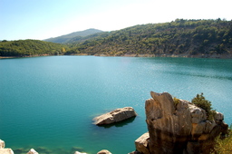
Pohled na Lac St.Croix

Interesujące miejsce po 39,6 km
Lac de St Croix du Verdon

Interesujące miejsce po 53,7 km
Camping le Vieux Chene
Kontynuuj z Bikemap
Użyj, edytuj lub pobierz tę trasę rowerową
Chcesz przejechać trasę 6. Tag Trigance - Bauduen lub dostosować ją do swojej wycieczki? Oto, co możesz zrobić z tą trasą na Bikemap:
Darmowe funkcje
- Zapisz tę trasę jako ulubioną lub w kolekcji
- Skopiuj i zaplanuj swoją wersję tej trasy
- Synchronizuj swoją trasę z Garminem lub Wahoo
Funkcje Premium
3 dni bezpłatnej wersji próbnej lub jednorazowa opłata. Dowiedz się więcej o Bikemap Premium.
- Nawiguj po tej trasie na iOS i Androidzie
- Eksportuj plik GPX / KML tej trasy
- Stwórz swój własny wydruk (wypróbuj za darmo)
- Pobierz tę trasę do nawigacji offline
Odkryj więcej funkcji Premium.
Uzyskaj Bikemap PremiumOd naszej społeczności
Castellane: Inne popularne trasy rozpoczynające się tutaj
 6. Tag Trigance - Bauduen
- Dystans
- 53,8 km
- Przewyższenia
- 957 m
- Spadek
- 1255 m
- Lokalizacja
- Castellane, Prowansja-Alpy-Lazurowe Wybrzeże, Francja
 2016 Ride Day 77 - Castellane circle via Croix del la Mission
- Dystans
- 26,8 km
- Przewyższenia
- 470 m
- Spadek
- 467 m
- Lokalizacja
- Castellane, Prowansja-Alpy-Lazurowe Wybrzeże, Francja
 Allauch 9. Etappe
- Dystans
- 122,8 km
- Przewyższenia
- 1204 m
- Spadek
- 1660 m
- Lokalizacja
- Castellane, Prowansja-Alpy-Lazurowe Wybrzeże, Francja
 Objezd kan.Verdon ze SEVERU_4.den
- Dystans
- 41,8 km
- Przewyższenia
- 1011 m
- Spadek
- 1277 m
- Lokalizacja
- Castellane, Prowansja-Alpy-Lazurowe Wybrzeże, Francja
 42 km Le Bourget - Gorges du Verdon
- Dystans
- 42,1 km
- Przewyższenia
- 515 m
- Spadek
- 512 m
- Lokalizacja
- Castellane, Prowansja-Alpy-Lazurowe Wybrzeże, Francja
 Tour du Verdon
- Dystans
- 84,8 km
- Przewyższenia
- 1726 m
- Spadek
- 1732 m
- Lokalizacja
- Castellane, Prowansja-Alpy-Lazurowe Wybrzeże, Francja
 RR Dingo Castel D2 110k
- Dystans
- 115,4 km
- Przewyższenia
- 4983 m
- Spadek
- 4986 m
- Lokalizacja
- Castellane, Prowansja-Alpy-Lazurowe Wybrzeże, Francja
 2016 Ride Day 78 - Castellane to Puget-Théniers
- Dystans
- 49,9 km
- Przewyższenia
- 441 m
- Spadek
- 749 m
- Lokalizacja
- Castellane, Prowansja-Alpy-Lazurowe Wybrzeże, Francja
Otwórz ją w aplikacji


