
L7 Abkürzung: Fontaines-Saint-Martin - Aurec-sur-Loire; 45+12km mit Bahn Givors-Firminy
Trasa rowerowa rozpoczynająca się w Fontaines-sur-Saône, Owernia-Rodan-Alpy, Francja.
Przegląd
O tej trasie
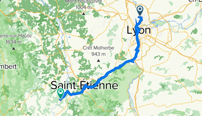
Fontaines-Saint-Martin - Lyon - (VR Via Rhona) - Pierre-Benite - Vernaison - Chateau de la Porte - Quartier Du Pont - Givors - Gare de Givors-Ville (45km) - Saint-Romain-en-Gier - La-Flechette - Rive-de-Gier - Izieux - Saint-Etienne Chateaucreux (Gare 28km bis Aurec-sur-Loire) - La Ricamarie - (V72) - Le Chambon-Feugerolles - Firminy (Gare - 12km bis Aurec-sur-Loire) - Saint-Paul-en-Cornillon - La Roche Bernard - Aurec-sur-Loire
- -:--
- Czas
- 112,5 km
- Dystans
- 1355 m
- Przewyższenia
- 1099 m
- Spadek
- ---
- Śr. Prędkość
- 624 m
- Maks. wysokość

Jakość trasy
Typy dróg i nawierzchnie na trasie
Typy dróg
Spokojna droga
38,2 km
(34 %)
Droga rowerowa
11,2 km
(10 %)
Powierzchnie
Utwardzona
72 km
(64 %)
Nieutwardzona
4,5 km
(4 %)
Asfalt
68,6 km
(61 %)
Beton
3,4 km
(3 %)
Najważniejsze punkty trasy
Punkty zainteresowania na trasie
Interesujące miejsce po 0,3 km
Château de Rochetaillée-sur-Saône
Interesujące miejsce po 3,7 km
Paul Bocuse Restaurant - Collonges-au-Mont-d'Or
Interesujące miejsce po 13 km
Notre-Dame de Fourvière
Interesujące miejsce po 13,7 km
Théâtre Gallo Romain de Lyon-Fourvière
Interesujące miejsce po 14,7 km
Fontaine Saint Jean
Interesujące miejsce po 15,1 km
Kathedrale von Lyon
Interesujące miejsce po 15,5 km
Kirche Saint-Georges
Interesujące miejsce po 16,3 km
Place Bellecour
Interesujące miejsce po 17,1 km
Statue of the Republic
Interesujące miejsce po 18 km
André Marie Ampère monument
Interesujące miejsce po 18,5 km
Le Monolithe
Interesujące miejsce po 20,3 km
Jardin du Musée des Confluences
Interesujące miejsce po 20,5 km
Zusammenfluß Rhone-Saone Confluent du Rhône et de la Saône
Interesujące miejsce po 21,6 km
Mulatiere’s Bridge
Interesujące miejsce po 24,4 km
Église Notre-Dame de Pierre Bénite
Interesujące miejsce po 38,3 km
Museum and site of Saint-Romain-en-Gal Vienne
Interesujące miejsce po 40,9 km
Hängebrücke in Givors
Nocleg po 41 km
Hotel Restaurant Le Bellevue, 1 Pl. du Carcan, 38370 Les Roches-de-Condrieu, Frankreich
Interesujące miejsce po 42,3 km
Givors Ville - La Gare 45km ab Fontaines-Saint-Martin
Interesujące miejsce po 85,5 km
St.Etinne Chateaucreux 27km bis Aurec-sur-Loire
Interesujące miejsce po 100,2 km
Firminy - La Gare 12 km nach Aurec-sur-Loire
Kontynuuj z Bikemap
Użyj, edytuj lub pobierz tę trasę rowerową
Chcesz przejechać trasę L7 Abkürzung: Fontaines-Saint-Martin - Aurec-sur-Loire; 45+12km mit Bahn Givors-Firminy lub dostosować ją do swojej wycieczki? Oto, co możesz zrobić z tą trasą na Bikemap:
Darmowe funkcje
- Zapisz tę trasę jako ulubioną lub w kolekcji
- Skopiuj i zaplanuj swoją wersję tej trasy
- Podziel trasę na etapy, aby utworzyć kilkudniową wycieczkę
- Synchronizuj swoją trasę z Garminem lub Wahoo
Funkcje Premium
3 dni bezpłatnej wersji próbnej lub jednorazowa opłata. Dowiedz się więcej o Bikemap Premium.
- Nawiguj po tej trasie na iOS i Androidzie
- Eksportuj plik GPX / KML tej trasy
- Stwórz swój własny wydruk (wypróbuj za darmo)
- Pobierz tę trasę do nawigacji offline
Odkryj więcej funkcji Premium.
Uzyskaj Bikemap PremiumOd naszej społeczności
Fontaines-sur-Saône: Inne popularne trasy rozpoczynające się tutaj
 MTDOR_CLASSIC
- Dystans
- 21,6 km
- Przewyższenia
- 816 m
- Spadek
- 813 m
- Lokalizacja
- Fontaines-sur-Saône, Owernia-Rodan-Alpy, Francja
 Fontaine-sur-Saône - Mâcon
- Dystans
- 68,3 km
- Przewyższenia
- 47 m
- Spadek
- 42 m
- Lokalizacja
- Fontaines-sur-Saône, Owernia-Rodan-Alpy, Francja
 L7 Abkürzung: Fontaines-Saint-Martin - Aurec-sur-Loire; 45+12km mit Bahn Givors-Firminy
- Dystans
- 112,5 km
- Przewyższenia
- 1355 m
- Spadek
- 1099 m
- Lokalizacja
- Fontaines-sur-Saône, Owernia-Rodan-Alpy, Francja
 Margot route
- Dystans
- 54,6 km
- Przewyższenia
- 286 m
- Spadek
- 285 m
- Lokalizacja
- Fontaines-sur-Saône, Owernia-Rodan-Alpy, Francja
 Parcours dimanche 2302
- Dystans
- 52,3 km
- Przewyższenia
- 375 m
- Spadek
- 377 m
- Lokalizacja
- Fontaines-sur-Saône, Owernia-Rodan-Alpy, Francja
 Tour de France 2016 dzień 19
- Dystans
- 101 km
- Przewyższenia
- 112 m
- Spadek
- 108 m
- Lokalizacja
- Fontaines-sur-Saône, Owernia-Rodan-Alpy, Francja
 L7: Fontaines-Saint-Martin - Roches-de-Condrieu; 67,1km 270hm
- Dystans
- 67,1 km
- Przewyższenia
- 432 m
- Spadek
- 467 m
- Lokalizacja
- Fontaines-sur-Saône, Owernia-Rodan-Alpy, Francja
 Quai de la Libération, Collonges-au-Mont-d'Or to 5 Chemin de la Chaîne, Ternay
- Dystans
- 30,1 km
- Przewyższenia
- 243 m
- Spadek
- 243 m
- Lokalizacja
- Fontaines-sur-Saône, Owernia-Rodan-Alpy, Francja
Otwórz ją w aplikacji