

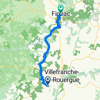
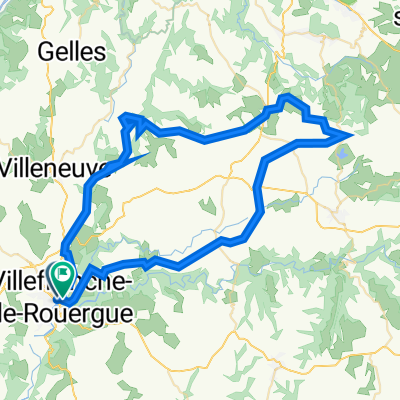
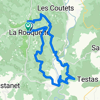
Villefranche-de-Rouergue - Circle through St Grat, Castanet, and Monteils
Trasa rowerowa rozpoczynająca się w Villefranche-de-Rouergue, Occitanie, Francja.
Przegląd
O tej trasie
To była doskonała trasa, głównie po malowniczych, rzadko uczęszczanych drogach wiejskich.
- 3 h 7 min
- Czas
- 53,1 km
- Dystans
- 708 m
- Przewyższenia
- 707 m
- Spadek
- 17 km/h
- Śr. Prędkość
- 479 m
- Maks. wysokość

Zdjęcia trasy


Jakość trasy
Typy dróg i nawierzchnie na trasie
Typy dróg
Droga
42,5 km
(80 %)
Spokojna droga
1,1 km
(2 %)
Powierzchnie
Utwardzona
15,9 km
(30 %)
Asfalt
15,4 km
(29 %)
Nawierzchnia (nieokreślona)
0,5 km
(1 %)
Niezdefiniowany
37,2 km
(70 %)
Kontynuuj z Bikemap
Użyj, edytuj lub pobierz tę trasę rowerową
Chcesz przejechać trasę Villefranche-de-Rouergue - Circle through St Grat, Castanet, and Monteils lub dostosować ją do swojej wycieczki? Oto, co możesz zrobić z tą trasą na Bikemap:
Darmowe funkcje
- Zapisz tę trasę jako ulubioną lub w kolekcji
- Skopiuj i zaplanuj swoją wersję tej trasy
- Synchronizuj swoją trasę z Garminem lub Wahoo
Funkcje Premium
3 dni bezpłatnej wersji próbnej lub jednorazowa opłata. Dowiedz się więcej o Bikemap Premium.
- Nawiguj po tej trasie na iOS i Androidzie
- Eksportuj plik GPX / KML tej trasy
- Stwórz swój własny wydruk (wypróbuj za darmo)
- Pobierz tę trasę do nawigacji offline
Odkryj więcej funkcji Premium.
Uzyskaj Bikemap PremiumOd naszej społeczności
Villefranche-de-Rouergue: Inne popularne trasy rozpoczynające się tutaj
 La Rouquette to 26 Rue d'Aujou, Figeac
- Dystans
- 47,6 km
- Przewyższenia
- 839 m
- Spadek
- 1008 m
- Lokalizacja
- Villefranche-de-Rouergue, Occitanie, Francja
 Od Dordogne do Provence 5.etapa
- Dystans
- 73,9 km
- Przewyższenia
- 507 m
- Spadek
- 646 m
- Lokalizacja
- Villefranche-de-Rouergue, Occitanie, Francja
 VDR lugan Bournazel
- Dystans
- 71,8 km
- Przewyższenia
- 1162 m
- Spadek
- 1166 m
- Lokalizacja
- Villefranche-de-Rouergue, Occitanie, Francja
 23 Km 800 D+ La Rouquette - Monteils
- Dystans
- 23,3 km
- Przewyższenia
- 803 m
- Spadek
- 801 m
- Lokalizacja
- Villefranche-de-Rouergue, Occitanie, Francja
 Dordogne 20130713
- Dystans
- 94,8 km
- Przewyższenia
- 812 m
- Spadek
- 952 m
- Lokalizacja
- Villefranche-de-Rouergue, Occitanie, Francja
 2014 Ride Day 89 - Villefranche-de-Rouergue to Cahors
- Dystans
- 81,4 km
- Przewyższenia
- 356 m
- Spadek
- 491 m
- Lokalizacja
- Villefranche-de-Rouergue, Occitanie, Francja
 Door to Door day 13 Villefranche de Rouergue - Bruniquel 23rd Sept
- Dystans
- 58 km
- Przewyższenia
- 723 m
- Spadek
- 963 m
- Lokalizacja
- Villefranche-de-Rouergue, Occitanie, Francja
 Combenegre Aveyron Lezert
- Dystans
- 23,4 km
- Przewyższenia
- 493 m
- Spadek
- 497 m
- Lokalizacja
- Villefranche-de-Rouergue, Occitanie, Francja
Otwórz ją w aplikacji