

St-Cesaire Magog (Omerville)
Trasa rowerowa rozpoczynająca się w Saint-Césaire, Québec, Kanada.
Przegląd
O tej trasie
.A good way to reach Mont-Orford-Magog and my cousins.
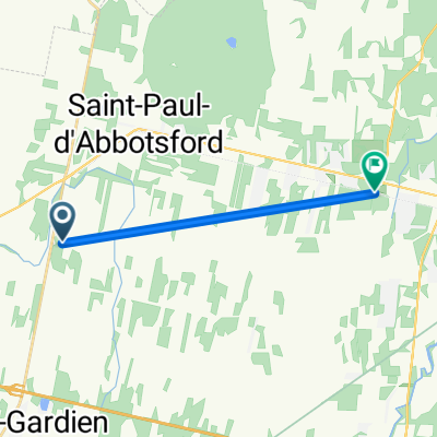
St- Cesaire offer a shaded Parking, Water, Restrooms, maps info during summertime. There a nice paved trail bike between St-Cesaire and Granby.Also An option for country roads though Cowie. Have an overview on Boivin Lake . Nice bicycle store around (go to 2nd floor)Later after Waterloo there is an option to explore the back road in Stuckely and Eastmain ,nice climb progressive and scenic on Dilligence road.Unfortunately ancient road is not continuing no problem going back on112 for one of the nicest view and rest area along Orford lake is rewarding.Picture?, . A lot of nice cafes and restaurants , especially in Magog! You could swim in Memphre Lake. The return is easier with 200 meters elevation.
- -:--
- Czas
- 78,6 km
- Dystans
- 502 m
- Przewyższenia
- 324 m
- Spadek
- ---
- Śr. Prędkość
- ---
- Maks. wysokość

Jakość trasy
Typy dróg i nawierzchnie na trasie
Typy dróg
Ruchliwa droga
34,7 km
(44 %)
Droga
26,2 km
(33 %)
Powierzchnie
Utwardzona
52,9 km
(67 %)
Nieutwardzona
2,8 km
(4 %)
Asfalt
35,5 km
(45 %)
Nawierzchnia (nieokreślona)
16,7 km
(21 %)
Najważniejsze punkty trasy
Punkty zainteresowania na trasie
Zdjęcie po 0,4 km
Interesujące miejsce po 0,7 km
Kontynuuj z Bikemap
Użyj, edytuj lub pobierz tę trasę rowerową
Chcesz przejechać trasę St-Cesaire Magog (Omerville) lub dostosować ją do swojej wycieczki? Oto, co możesz zrobić z tą trasą na Bikemap:
Darmowe funkcje
- Zapisz tę trasę jako ulubioną lub w kolekcji
- Skopiuj i zaplanuj swoją wersję tej trasy
- Synchronizuj swoją trasę z Garminem lub Wahoo
Funkcje Premium
3 dni bezpłatnej wersji próbnej lub jednorazowa opłata. Dowiedz się więcej o Bikemap Premium.
- Nawiguj po tej trasie na iOS i Androidzie
- Eksportuj plik GPX / KML tej trasy
- Stwórz swój własny wydruk (wypróbuj za darmo)
- Pobierz tę trasę do nawigacji offline
Odkryj więcej funkcji Premium.
Uzyskaj Bikemap PremiumOd naszej społeczności
Saint-Césaire: Inne popularne trasy rozpoczynające się tutaj
 St-Cesaire Magog (Omerville) .
- Dystans
- 82,6 km
- Przewyższenia
- 539 m
- Spadek
- 349 m
- Lokalizacja
- Saint-Césaire, Québec, Kanada
 st-césaire, tour du mont rougemont
- Dystans
- 69,4 km
- Przewyższenia
- 51 m
- Spadek
- 52 m
- Lokalizacja
- Saint-Césaire, Québec, Kanada
 Route des cidres - Rougemont
- Dystans
- 40,6 km
- Przewyższenia
- 117 m
- Spadek
- 116 m
- Lokalizacja
- Saint-Césaire, Québec, Kanada
 Saint-Césaire à Granby, aller-retour
- Dystans
- 67,3 km
- Przewyższenia
- 204 m
- Spadek
- 206 m
- Lokalizacja
- Saint-Césaire, Québec, Kanada
 St-Cesaire Magog (Omerville)
- Dystans
- 78,6 km
- Przewyższenia
- 502 m
- Spadek
- 324 m
- Lokalizacja
- Saint-Césaire, Québec, Kanada
 Route to Granby
- Dystans
- 10,1 km
- Przewyższenia
- 27 m
- Spadek
- 0 m
- Lokalizacja
- Saint-Césaire, Québec, Kanada
 cesaire rougemont
- Dystans
- 44 km
- Przewyższenia
- 114 m
- Spadek
- 115 m
- Lokalizacja
- Saint-Césaire, Québec, Kanada
 St-Césaire-Tour Lac Boivin
- Dystans
- 67,8 km
- Przewyższenia
- 211 m
- Spadek
- 211 m
- Lokalizacja
- Saint-Césaire, Québec, Kanada
Otwórz ją w aplikacji